Åmli (village)
| Åmli | |
|---|---|
| Village | |
 View of the village | |
 Åmli Location of the village  Åmli Åmli (Norway) | |
| Coordinates: 58°45′57″N 8°29′02″E / 58.7657°N 08.4839°ECoordinates: 58°45′57″N 8°29′02″E / 58.7657°N 08.4839°E | |
| Country | Norway |
| Region | Southern Norway |
| County | Aust-Agder |
| District | Østre Agder |
| Municipality | Åmli |
| Area[1] | |
| • Total | 0.80 km2 (0.31 sq mi) |
| Elevation[2] | 159 m (522 ft) |
| Population (2017)[1] | |
| • Total | 682 |
| • Density | 853/km2 (2,210/sq mi) |
| Time zone | UTC+01:00 (CET) |
| • Summer (DST) | UTC+02:00 (CEST) |
| Post Code | 4865 Åmli |
Åmli is the administrative centre of Åmli municipality in Aust-Agder county, Norway. The village is located along the Norwegian National Road 41 and the river Nidelva, about 30 kilometres (19 mi) northwest of the town of Tvedestrand via the Norwegian County Road 415. The village of Nelaug lies about 15 kilometres (9.3 mi) to the southeast and the village of Dølemo lies about 10 kilometres (6.2 mi) to the southwest. The 0.8-square-kilometre (200-acre) village has a population (2017) of 682 which gives the village a population density of 853 inhabitants per square kilometre (2,210/sq mi).[1]
The village of Åmli is the location of the municipal government as well as Åmli Church, the main church for the municipality. There is also a school, library, and museum. The village is the largest in the municipality, so it is also the main area of commerce in the municipality. The Åmliavisa newspaper is published weekly from Åmli. The southernmost part of the village is sometimes referred to as Lauveik.
Media gallery
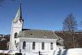 Åmli Church
 Municipal building
 Åmli school
 Åmli power station
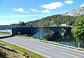 Åmfoss bridge in Åmli
 Former train station, now a library
References
- 1 2 3 Statistisk sentralbyrå (1 January 2017). "Urban settlements. Population and area, by municipality".
- ↑ "Åmli (Aust-Agder)". yr.no. Retrieved 2017-12-20.