Mjøsa
| Mjøsa | |
|---|---|
 | |
| Location | Akershus, Hedmark, Oppland |
| Coordinates | 60°40′N 11°00′E / 60.667°N 11.000°ECoordinates: 60°40′N 11°00′E / 60.667°N 11.000°E |
| Primary inflows | Gudbrandsdalslågen |
| Primary outflows | Vorma |
| Basin countries | Norway |
| Max. length | 117 km (73 mi) |
| Max. width | 15 km (9.3 mi) |
| Surface area | 362 km2 (140 sq mi)[1] |
| Average depth | 155 m (509 ft)[1] (other source 153 m[2]) |
| Max. depth | 449 m (1,473 ft)[1][2] (other sources give 468 m) |
| Water volume | 56.0 km3 (45,400,000 acre⋅ft)[1] |
| Surface elevation | 121 m (397 ft)[1] (other sources give 123 m[2]) |
| Islands | Helgøya |
| Settlements | Hamar, Gjøvik, Lillehammer |
| References | [1] |
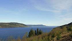
Mjøsa is Norway's largest lake, as well as one of the deepest lakes in Norway and in Europe. It is the fourth-deepest lake in Norway. It is located in the southern part of Norway, about 100 km north of Oslo. Its main tributary is Gudbrandsdalslågen in the north; the only distributary is Vorma in the south. Inflows would theoretically need 5.6 years to fill the lake. With an average depth of 153 meters most of the lakes volume is under sea level. Average outflow (measured 1931-1982) is 316 m3/s or 9959 million m3.[2]
Thomas Robert Malthus travelled through Norway in 1799 and his diaries from the trip includes a description of Mjøsa. Malthus wrote that Mjøsa appears as both lake and river because the shores are defined by mountains and where the valley becomes wider the water fills the space. Below Minde (Minnesund) the lake only appears like a river and is called Vorma on the map, according to Malthus.[3]
Location
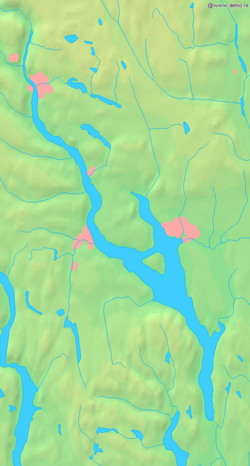
From its southernmost point at Minnesund in Eidsvoll to its northernmost point in Lillehammer it is 117 km long. At its widest, near Hamar, it is 15 km wide. It is 365 km² in area and its volume is estimated at 56 km³; normally its surface is 123 metres above sea level, and its greatest depth is 468 metres. Its total coastline is estimated at 273 km, of which 30% is built up. Dams built on the distribuary of Vorma in 1858, 1911, 1947, and 1965 raised the level by approximately 3.6 metres in total. In the last 200 years, 20 floods have been registered that added 7 metres to the level of Mjøsa. Several of these floods inundated the city of Hamar.
The cities of Hamar, Gjøvik, and Lillehammer were founded along the shores of the lake. Before the construction of railways past the lake, it was an important transport route. Today, aside from minor leisure boating and the steamship Skibladner, there is no water traffic on the lake. Most of its shores are dominated by rolling agricultural areas, among them some of the most fertile grainlands in Norway. The main train line, the Dovre Line between Oslo and Trondheim, goes along its eastern shore, making stops in Hamar and Lillehammer. From the south European route E6 runs along the eastern shore of the lake until the Mjøsa Bridge connects Moelv on the east with Biri on the west.
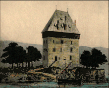
Mjøskastellet
The largest and only island is Helgøya. Except for Helgøya, Mjøsa only contains small islets. The most interesting of these is Steinsholmen, which holds the ruins of Mjøskastellet, a medieval citadel dating from the 13th century. Established by King Haakon IV of Norway, it was first mentioned in a letter dated 1234. Peter Andreas Blix documented the site and made drawings in 1897. Hedmark Museum has a future archaeological plan for the site. [4][5]
Fish
Lake Mjøsa has 20 species of fish. Among the most common are pike, European perch, common roach, greyling, and the hundertrout, a brown trout which can reach a weight more than 20 kg. Another common species is the European smelt, which is the most important baitfish for the predators. Historically, the most economically significant species is the lågsild (European cisco).
The name
The name (Norse Mjǫrs, Proto-Norse *Merso) must be very old. The meaning is, maybe, 'the bright/shiny one'. (If *mer- is related to the English word mere 'clear, bright', and -so is a suffix.)
 The lake seen from the harbor in Hamar
 The landmark Geiteryggen looking south from Hamar
 Mjøsa from Hamar
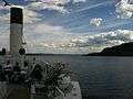 Steamboat Skibladner on the lake of Mjøsa
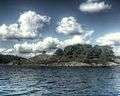 Steinholmen on lake Mjøsa
Events
In 1975, the 14th World Scout Jamboree was held on its shores. More than 17,000 Scouts from 91 countries took part.
In 1995, a Swedish team lifted a Halifax bomber that was shot down in World War II.
See also
Culture projects
| Wikimedia Commons has media related to Mjøsa. |
References
- 1 2 3 4 5 6 Seppälä, Matti (2005), The Physical Geography of Fennoscandia, Oxford University Press, p. 145, ISBN 978-0-19-924590-1
- 1 2 3 4 Dybdekart for Mjøsa (PDF), Dybdekartbok, NVE (Norwegian Water Resources and Energy Directorate), 1984, s.22
- ↑ Selstad, Tor (red.) og Arve Stensrud: Den Store Mjøsboka. Oslo: Pegasus, 1991.
- ↑ "Mjøskastellet på Steinsholmen". Mjøssamlingene. Retrieved June 1, 2017.
- ↑ "Mjøskastellet". Store norske leksikon. Retrieved June 1, 2017.
External links
- Mjøskastellet (DigitaltMuseum)