Evangervatnet
| Evangervatnet | |
|---|---|
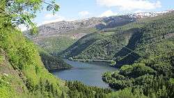 View of the lake | |
| Location | Voss, Hordaland |
| Coordinates | 60°39′00″N 6°3′48″E / 60.65000°N 6.06333°E / 60.65000; 6.06333Coordinates: 60°39′00″N 6°3′48″E / 60.65000°N 6.06333°E / 60.65000; 6.06333 |
| Basin countries | Norway |
| Max. length | 6 kilometres (3.7 mi) |
| Max. width | 1 kilometre (0.62 mi) |
| Surface area | 2.96 km2 (1.14 sq mi) |
| Shore length1 | 15.4 kilometres (9.6 mi) |
| Surface elevation | 11 metres (36 ft) |
| Settlements | Evanger |
| References | NVE |
| 1 Shore length is not a well-defined measure. | |
Evangervatnet or Lake Evanger is a lake in the municipality of Voss in Hordaland county, Norway. The Vosso River flows through both Vangsvatnet and Evangervatnet before it empties into Bolstadfjorden by the village of Bolstadøyri. Evangervatnet is named for the village of Evanger, located on the eastern end of the lake. The last element vatnet is the definite form of vatn meaning lake.[1]
European route E16 highway and the Bergen Line both run along the southern shore of the lake. The northern shore of the lake is mostly mountainous and uninhabited.
See also
References
- ↑ Store norske leksikon. "Vosso" (in Norwegian). Retrieved 2014-05-14.
This article is issued from
Wikipedia.
The text is licensed under Creative Commons - Attribution - Sharealike.
Additional terms may apply for the media files.