Nidelva (Aust-Agder)
| Nidelva | |
|---|---|
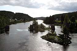 Nidelva near Blakstad in Froland | |
 Location of the river  Nidelva (Aust-Agder) (Norway) | |
| Country | Norway |
| Counties | Aust-Agder, Telemark |
| Municipalities | Grimstad, Arendal, Froland, Åmli, Nissedal |
| Physical characteristics | |
| Main source |
Confluence of Nisserelva and Fyresdalsåna rivers Haugsjåsund, Nissedal, Telemark 160 metres (520 ft) 58°56′26″N 8°30′04″E / 58.9406°N 08.5011°E |
| River mouth |
Skaggerak Arendal, Aust-Agder 0 metres (0 ft) 58°26′06″N 8°42′49″E / 58.4349°N 08.7137°ECoordinates: 58°26′06″N 8°42′49″E / 58.4349°N 08.7137°E |
| Length | 221.7 km (137.8 mi) |
| Discharge | |
| Basin features | |
| River system | Arendalvassdraget |
| Basin size | 4,011 km2 (1,549 sq mi) |
| Tributaries |
|
| Waterbodies | Nelaug |
| Waterfalls | Kastefossen |
Nidelva is the main river in the Arendal drainage basin in Aust-Agder county, Norway. The 221.7-kilometre (137.8 mi) long river begins at the confluence of two rivers: Nisserelva and Fyreselv. The confluence is located by the village of Haugsjåsund in Nissedal municipality in southern Telemark county. The river flows south into the Skagerrak at the city of Arendal. The watershed covers 4,011 square kilometres (1,549 sq mi) and has an average waterflow of 114.4 cubic metres per second (4,040 cu ft/s) at Rykene near the mouth. The highest waterflow ever recorded on the river was 1,200 cubic metres per second (42,000 cu ft/s) in the autumn of 1987.
Watercourse
The river flows through Nissedal in Telemark county briefly before entering Aust-Agder county. It then flows through Åmli municipality. The river Gjøv joins the Nidelva there. The large lake Nelaug is a man-made lake along the river that is used for power generation. It continues through Froland municipality and then Arendal municipality. For a while, the river forms the border between Grimstad and Arendal municipalities. The river empties into the Skaggerak just northeast of Rykene in the town of Arendal between the mainland and the island of Hisøya.[1]
There are sixteen hydro-electric power stations are built along the river, making this one of Norway's most controlled drainage systems. The largest on the river are at Rygene in Grimstad, Evenstad in Froland, and Jørundland in Åmli.[1] Salmon can be found from the mouth to as far as 22 kilometres (14 mi) up the river, where the Evenstad power station is located, effectively blocking their path further upstream.[2]
Name
The name of the river possibly comes from the Old Norse word niðr which means "the river that is lying down". It may also come from the Latin word nitere. The name of the river also may lend itself to several other local names along the river such as Nisser, Nedenes, and Nelaug.[1]
Media gallery
.jpg) View of the River Nid by John William Edy
View of the River Nid by John William Edy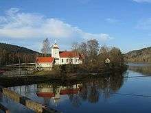 Froland Church located along the river Nidelva
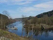 View of the river in Arendal
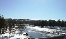 View of the river near Gjermundsnes in Åmli
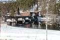 Åmfossen power station along the river in Åmli
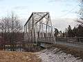 Furre bridge over the river in Froland
References
- 1 2 3 Thorsnæs, Geir, ed. (2017-03-22). "Nidelva – elv i Aust-Agder". Store norske leksikon (in Norwegian). Kunnskapsforlaget. Retrieved 2017-11-09.
- ↑ Finstad, A.G; Økland, F.; Thorstad, E.B.; Heggberget, T.G. (2005-10-06). "Comparing upriver spawning migration of Atlantic salmon Salmo salar and sea trout Salmo trutta". Journal of Fish Biology. 67 (4): 919–930. doi:10.1111/j.0022-1112.2005.00792.x.
External links

- Evenstad power station (in Norwegian)