Fort Inge
|
Fort Inge Archeological Site | |
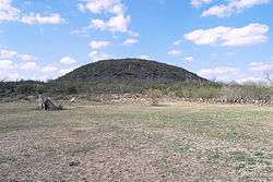 The site of Fort Inge archeological site with Mount Inge in the background | |
 Fort Inge Archeological Site  Fort Inge Archeological Site | |
| Location | FM 140 SE of Uvalde, Texas |
|---|---|
| Coordinates | 29°10′40″N 99°45′52″W / 29.17778°N 99.76444°WCoordinates: 29°10′40″N 99°45′52″W / 29.17778°N 99.76444°W |
| Area | 39 acres (16 ha) |
| Built | 1849 |
| NRHP reference # | 85002298[1] |
| Added to NRHP | September 12, 1985 |
Fort Inge was a frontier fort in Uvalde County, Texas, United States. Established as Camp Leona on March 13, 1849, it was garrisoned intermittently until March 19, 1869. The fort served as a base for United States Army troops assigned to protect the southern overland mail route along the San Antonio-El Paso Road from Indian raids. The camp was renamed Fort Inge in honor of Lieutenant Zebulon M. P. Inge a West Point officer killed in the Mexican–American War. Other forts in the frontier fort system were Forts Griffin, Concho, Belknap, Chadbourne, Fort Stockton, Fort Davis, Fort Bliss, Fort Mason, McKavett, Clark, Fort McIntosh, Richardson and Phantom Hill in Texas, and Fort Sill in Oklahoma.[2]:48 There were "sub posts or intermediate stations" including Bothwick's Station on Salt Creek between Fort Richardson and Fort Belknap, Camp Wichita near Buffalo Springs between Fort Richardson and Red River Station, and Mountain Pass between Fort Concho and Fort Griffin.[2]:49
There were two wooden barracks with thatched roofs that quartered the soldiers assigned to the fort. There was also a large limestone building that served as commissary and later a hospital. The buildings at Ft. Inge were never sufficient for the troops stationed there, probably because this post was never determined by the Army to be a permanent post. It was started in 1849 but abandoned in the spring of 1851. It was reoccupied that same summer and occupied until 1855 when it was abandoned again. It was reoccupied a third time in 1856 but was abandoned in 1861 to Confederate States Army troops.[3] It was again garrisoned briefly in 1865 by the 4th Wisconsin Cavalry.
The United States Army regarrisoned the fort until March 19, 1869, when the garrison was transferred to Fort McKavett. The army recovered materials from the site to use for additions to nearby Fort Clark. Fort Inge then saw use as a camp by the Texas Rangers until 1884.
The fort was surrounded on three sides by a stacked stone wall added approximately at the time of the Civil War. The wall was dismantled in 1874 and the stone used to build a dam on the Leona River. The wall was relaid along its original lines in 1984.
Jerome Napoleon Bonaparte II was posted to Fort Inge in the early 1850s, and his letters from there are preserved by the Maryland Historical Society.
In 1961, the site became the Fort Inge Historical Site County Park. It was added to the National Register of Historic Places on September 12, 1985.[4] The site is located on the Leona River and is dominated by the 140-foot (43 m) high remains of an extinct volcano named Mount Inge.
Major Neighbors
Robert Neighbors arrived at the fort on 7 April 1854, investigating Indian depredations and found the raiding party consisted of twelve Tonkawas, two of which were killed and nine turned over to the fort.[5]:114 Neighbors also freed the Lipan Chief Chiquito and his men from the guard house, and charged Indian Agent Howard with "dereliction of duty" for their false arrest and mismanagement of the Indian situation.[5]:114
Gallery
 Fort Inge
 Fort Inge
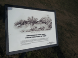 Trousset's 1867 drawing
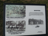 Eastman's 1849 drawing
See also
References
- ↑ National Park Service (2010-07-09). "National Register Information System". National Register of Historic Places. National Park Service.
- 1 2 Carter, R.G., On the Border with Mackenzie, 1935, Washington D.C.: Enyon Printing Co.
- ↑ Herbert M. Hart, Old Forts of the Southwest, Superior Publishing Company, Seattle, Washington, 1964, First Edition
- ↑ Staff Writer. "Fort Inge Archeological Site." National Register of Historic Places. Accessed April 17, 2007. Retrieved on 2007-04-17.
- 1 2 Neighbours, K.F., 1975, Robert Neighbors and the Texas Frontier, 1836-1859, Waco: Texian Press
External links
| Wikimedia Commons has media related to Fort Inge. |
- Fort Inge Historical Park - Uvalde County
- Fort Inge from the Handbook of Texas Online
- Jerome Napoleon Bonaparte, Jr from the Handbook of Texas Online
- U.S. Geological Survey Geographic Names Information System: Fort Inge, Texas
- "Fort Inge - Uvalde ~ Marker Number: 4793". Texas Historic Sites Atlas. Texas Historical Commission. 1966.
- "Fort Inge Archeological Site - Uvalde ~ National Register: 85002298". Texas Historic Sites Atlas. Texas Historical Commission. 1985.
- "U.S. Army on the Texas Frontier". Texas Beyond History. University of Texas at Austin.


Municipalities and communities of Uvalde County, Texas, United States | ||
|---|---|---|
| Cities | 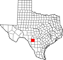 | |
| CDPs | ||
| Unincorporated community | ||
| Ghost town | ||