Montrichard-Val-de-Cher
| Montrichard-Val-de-Cher | |
|---|---|
| Commune | |
 The Cher | |
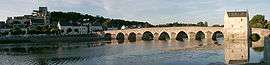
 Montrichard-Val-de-Cher Location within Centre-Val de Loire region  Montrichard-Val-de-Cher | |
| Coordinates: 47°20′35″N 1°11′02″E / 47.343°N 1.184°ECoordinates: 47°20′35″N 1°11′02″E / 47.343°N 1.184°E | |
| Country | France |
| Region | Centre-Val de Loire |
| Department | Loir-et-Cher |
| Arrondissement | Romorantin-Lanthenay |
| Canton | Montrichard |
| Government | |
| • Mayor (2016–2020) | Jean-Marie Janssens |
| Area1 | 19.20 km2 (7.41 sq mi) |
| Population (2014)2 | 3,913 |
| • Density | 200/km2 (530/sq mi) |
| Time zone | UTC+1 (CET) |
| • Summer (DST) | UTC+2 (CEST) |
| INSEE/Postal code | 41151 /41400 |
| Elevation | 58–134 m (190–440 ft) |
|
1 French Land Register data, which excludes lakes, ponds, glaciers > 1 km2 (0.386 sq mi or 247 acres) and river estuaries. 2 Population without double counting: residents of multiple communes (e.g., students and military personnel) only counted once. | |
Montrichard-Val-de-Cher is a commune in the Loir-et-Cher department of central France. The municipality was established on 1 January 2016 by merger of the former communes of Montrichard and Bourré.[1]
See also
References
- ↑ Arrêté préfectoral 2 December 2015 (in French)
| Wikimedia Commons has media related to Montrichard-Val-de-Cher. |
This article is issued from
Wikipedia.
The text is licensed under Creative Commons - Attribution - Sharealike.
Additional terms may apply for the media files.