Saint-Georges-sur-Cher
| Saint-Georges-sur-Cher | ||
|---|---|---|
| Commune | ||
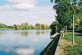 Cher River | ||
| ||
 Saint-Georges-sur-Cher Location within Centre-Val de Loire region  Saint-Georges-sur-Cher | ||
| Coordinates: 47°19′33″N 1°07′34″E / 47.3258°N 1.1261°ECoordinates: 47°19′33″N 1°07′34″E / 47.3258°N 1.1261°E | ||
| Country | France | |
| Region | Centre-Val de Loire | |
| Department | Loir-et-Cher | |
| Arrondissement | Romorantin-Lanthenay | |
| Canton | Montrichard | |
| Government | ||
| • Mayor (2014–2020) | Jacques Paoletti | |
| Area1 | 23.78 km2 (9.18 sq mi) | |
| Population (2015)2 | 2,645 | |
| • Density | 110/km2 (290/sq mi) | |
| Time zone | UTC+1 (CET) | |
| • Summer (DST) | UTC+2 (CEST) | |
| INSEE/Postal code | 41211 /41400 | |
| Elevation |
56–141 m (184–463 ft) (avg. 111 m or 364 ft) | |
|
1 French Land Register data, which excludes lakes, ponds, glaciers > 1 km2 (0.386 sq mi or 247 acres) and river estuaries. 2 Population without double counting: residents of multiple communes (e.g., students and military personnel) only counted once. | ||
.svg.png)
Saint-Georges-sur-Cher is a commune in the Loir-et-Cher department of central France.
Population
| Historical population | ||
|---|---|---|
| Year | Pop. | ±% |
| 1793 | 1,312 | — |
| 1806 | 1,546 | +17.8% |
| 1821 | 1,681 | +8.7% |
| 1831 | 1,976 | +17.5% |
| 1841 | 2,084 | +5.5% |
| 1851 | 2,158 | +3.6% |
| 1861 | 2,290 | +6.1% |
| 1872 | 2,350 | +2.6% |
| 1881 | 2,518 | +7.1% |
| 1891 | 2,233 | −11.3% |
| 1901 | 2,139 | −4.2% |
| 1911 | 2,031 | −5.0% |
| 1921 | 1,906 | −6.2% |
| 1931 | 1,739 | −8.8% |
| 1946 | 1,688 | −2.9% |
| 1954 | 1,736 | +2.8% |
| 1962 | 1,647 | −5.1% |
| 1968 | 1,673 | +1.6% |
| 1975 | 1,783 | +6.6% |
| 1982 | 2,021 | +13.3% |
| 1990 | 2,047 | +1.3% |
| 1999 | 2,155 | +5.3% |
| 2006 | 2,268 | +5.2% |
| 2015 | 2,645 | +16.6% |
See also
References
External links
| Wikimedia Commons has media related to Saint-Georges-sur-Cher. |
This article is issued from
Wikipedia.
The text is licensed under Creative Commons - Attribution - Sharealike.
Additional terms may apply for the media files.