Menars
| Menars | ||
|---|---|---|
| Commune | ||
 | ||
| ||
 Menars Location within Centre-Val de Loire region  Menars | ||
| Coordinates: 47°38′36″N 1°24′34″E / 47.6433°N 1.4094°ECoordinates: 47°38′36″N 1°24′34″E / 47.6433°N 1.4094°E | ||
| Country | France | |
| Region | Centre-Val de Loire | |
| Department | Loir-et-Cher | |
| Arrondissement | Blois | |
| Canton | Blois-2 | |
| Intercommunality | Communauté d'agglomération de Blois | |
| Government | ||
| • Mayor (2014–2020) | Yves Georges | |
| Area1 | 4.5 km2 (1.7 sq mi) | |
| Population (2014)2 | 620 | |
| • Density | 140/km2 (360/sq mi) | |
| Time zone | UTC+1 (CET) | |
| • Summer (DST) | UTC+2 (CEST) | |
| INSEE/Postal code | 41134 /41500 | |
| Elevation |
67–111 m (220–364 ft) (avg. 98 m or 322 ft) | |
|
1 French Land Register data, which excludes lakes, ponds, glaciers > 1 km2 (0.386 sq mi or 247 acres) and river estuaries. 2 Population without double counting: residents of multiple communes (e.g., students and military personnel) only counted once. | ||
.svg.png)
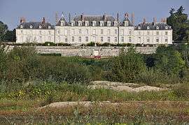
Menars is a commune in the Loir-et-Cher department of central France. The Château de Menars, formerly owned by Madame de Pompadour is located here.
Population
| Historical population | ||
|---|---|---|
| Year | Pop. | ±% |
| 1793 | 412 | — |
| 1806 | 432 | +4.9% |
| 1821 | 462 | +6.9% |
| 1831 | 449 | −2.8% |
| 1841 | 712 | +58.6% |
| 1851 | 605 | −15.0% |
| 1861 | 677 | +11.9% |
| 1872 | 654 | −3.4% |
| 1881 | 540 | −17.4% |
| 1891 | 530 | −1.9% |
| 1901 | 470 | −11.3% |
| 1911 | 440 | −6.4% |
| 1921 | 434 | −1.4% |
| 1931 | 405 | −6.7% |
| 1946 | 409 | +1.0% |
| 1954 | 397 | −2.9% |
| 1962 | 415 | +4.5% |
| 1968 | 431 | +3.9% |
| 1975 | 474 | +10.0% |
| 1982 | 550 | +16.0% |
| 1990 | 551 | +0.2% |
| 1999 | 574 | +4.2% |
| 2008 | 611 | +6.4% |
| 2014 | 620 | +1.5% |
See also
References
| Wikimedia Commons has media related to Menars. |
This article is issued from
Wikipedia.
The text is licensed under Creative Commons - Attribution - Sharealike.
Additional terms may apply for the media files.