Meslay, Loir-et-Cher
| Meslay | ||
|---|---|---|
| Commune | ||
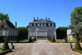 Chateau | ||
| ||
 Meslay Location within Centre-Val de Loire region  Meslay | ||
| Coordinates: 47°48′44″N 1°06′00″E / 47.8122°N 1.1°ECoordinates: 47°48′44″N 1°06′00″E / 47.8122°N 1.1°E | ||
| Country | France | |
| Region | Centre-Val de Loire | |
| Department | Loir-et-Cher | |
| Arrondissement | Vendôme | |
| Canton | Vendôme | |
| Intercommunality | Vendômois Rural | |
| Government | ||
| • Mayor (2014–2020) | Jacky Foussard | |
| Area1 | 7.18 km2 (2.77 sq mi) | |
| Population (2014)2 | 309 | |
| • Density | 43/km2 (110/sq mi) | |
| Time zone | UTC+1 (CET) | |
| • Summer (DST) | UTC+2 (CEST) | |
| INSEE/Postal code | 41138 /41100 | |
| Elevation |
77–130 m (253–427 ft) (avg. 83 m or 272 ft) | |
|
1 French Land Register data, which excludes lakes, ponds, glaciers > 1 km2 (0.386 sq mi or 247 acres) and river estuaries. 2 Population without double counting: residents of multiple communes (e.g., students and military personnel) only counted once. | ||
.svg.png)
Meslay is a commune in the Loir-et-Cher department of central France.
Population
| Historical population | ||
|---|---|---|
| Year | Pop. | ±% |
| 1793 | 266 | — |
| 1806 | 278 | +4.5% |
| 1821 | 277 | −0.4% |
| 1831 | 277 | +0.0% |
| 1841 | 275 | −0.7% |
| 1851 | 269 | −2.2% |
| 1861 | 264 | −1.9% |
| 1872 | 242 | −8.3% |
| 1881 | 225 | −7.0% |
| 1891 | 205 | −8.9% |
| 1901 | 223 | +8.8% |
| 1911 | 215 | −3.6% |
| 1921 | 164 | −23.7% |
| 1931 | 169 | +3.0% |
| 1946 | 204 | +20.7% |
| 1954 | 263 | +28.9% |
| 1962 | 223 | −15.2% |
| 1968 | 233 | +4.5% |
| 1975 | 225 | −3.4% |
| 1982 | 344 | +52.9% |
| 1990 | 329 | −4.4% |
| 1999 | 294 | −10.6% |
| 2007 | 300 | +2.0% |
| 2014 | 309 | +3.0% |
See also
References
| Wikimedia Commons has media related to Meslay (Loir-et-Cher). |
This article is issued from
Wikipedia.
The text is licensed under Creative Commons - Attribution - Sharealike.
Additional terms may apply for the media files.