Selommes
| Selommes | ||
|---|---|---|
| Commune | ||
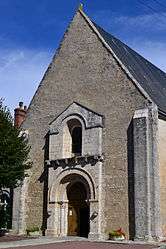 Church of the Holy Virgin | ||
| ||
 Selommes Location within Centre-Val de Loire region  Selommes | ||
| Coordinates: 47°45′24″N 1°11′34″E / 47.7567°N 1.1928°ECoordinates: 47°45′24″N 1°11′34″E / 47.7567°N 1.1928°E | ||
| Country | France | |
| Region | Centre-Val de Loire | |
| Department | Loir-et-Cher | |
| Arrondissement | Vendôme | |
| Canton | Montoire-sur-le-Loir | |
| Intercommunality | Beauce et Gâtine | |
| Government | ||
| • Mayor (2014–2020) | Claire Foucher-Maupetit | |
| Area1 | 28.01 km2 (10.81 sq mi) | |
| Population (2015)2 | 823 | |
| • Density | 29/km2 (76/sq mi) | |
| Time zone | UTC+1 (CET) | |
| • Summer (DST) | UTC+2 (CEST) | |
| INSEE/Postal code | 41243 /41100 | |
| Elevation |
107–131 m (351–430 ft) (avg. 116 m or 381 ft) | |
|
1 French Land Register data, which excludes lakes, ponds, glaciers > 1 km2 (0.386 sq mi or 247 acres) and river estuaries. 2 Population without double counting: residents of multiple communes (e.g., students and military personnel) only counted once. | ||
.svg.png)
Selommes is a commune in the Loir-et-Cher department of central France.
Population
| Historical population | ||
|---|---|---|
| Year | Pop. | ±% |
| 1793 | 662 | — |
| 1806 | 653 | −1.4% |
| 1821 | 689 | +5.5% |
| 1831 | 749 | +8.7% |
| 1841 | 717 | −4.3% |
| 1851 | 881 | +22.9% |
| 1861 | 846 | −4.0% |
| 1872 | 796 | −5.9% |
| 1881 | 860 | +8.0% |
| 1891 | 862 | +0.2% |
| 1901 | 846 | −1.9% |
| 1911 | 843 | −0.4% |
| 1921 | 763 | −9.5% |
| 1931 | 766 | +0.4% |
| 1946 | 719 | −6.1% |
| 1954 | 731 | +1.7% |
| 1962 | 730 | −0.1% |
| 1968 | 714 | −2.2% |
| 1975 | 705 | −1.3% |
| 1982 | 720 | +2.1% |
| 1990 | 734 | +1.9% |
| 1999 | 758 | +3.3% |
| 2006 | 851 | +12.3% |
| 2015 | 823 | −3.3% |
See also
| Wikimedia Commons has media related to Selommes. |
This article is issued from
Wikipedia.
The text is licensed under Creative Commons - Attribution - Sharealike.
Additional terms may apply for the media files.