Villavard
| Villavard | ||
|---|---|---|
| Commune | ||
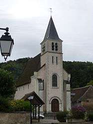 Church of Our Lady | ||
| ||
 Villavard Location within Centre-Val de Loire region  Villavard | ||
| Coordinates: 47°45′35″N 0°54′21″E / 47.7597°N 0.9058°ECoordinates: 47°45′35″N 0°54′21″E / 47.7597°N 0.9058°E | ||
| Country | France | |
| Region | Centre-Val de Loire | |
| Department | Loir-et-Cher | |
| Arrondissement | Vendôme | |
| Canton | Montoire-sur-le-Loir | |
| Intercommunality | Pays de Ronsard | |
| Government | ||
| • Mayor (2014–2020) | Aimé Houdebert | |
| Area1 | 5.18 km2 (2.00 sq mi) | |
| Population (2015)2 | 127 | |
| • Density | 25/km2 (63/sq mi) | |
| Time zone | UTC+1 (CET) | |
| • Summer (DST) | UTC+2 (CEST) | |
| INSEE/Postal code | 41274 /41800 | |
| Elevation |
65–131 m (213–430 ft) (avg. 70 m or 230 ft) | |
|
1 French Land Register data, which excludes lakes, ponds, glaciers > 1 km2 (0.386 sq mi or 247 acres) and river estuaries. 2 Population without double counting: residents of multiple communes (e.g., students and military personnel) only counted once. | ||
.svg.png)
Villavard is a commune in the Loir-et-Cher department in central France.
Population
| Historical population | ||
|---|---|---|
| Year | Pop. | ±% |
| 1793 | 298 | — |
| 1806 | 325 | +9.1% |
| 1821 | 256 | −21.2% |
| 1831 | 259 | +1.2% |
| 1841 | 281 | +8.5% |
| 1851 | 337 | +19.9% |
| 1861 | 326 | −3.3% |
| 1872 | 277 | −15.0% |
| 1881 | 265 | −4.3% |
| 1891 | 238 | −10.2% |
| 1901 | 251 | +5.5% |
| 1911 | 238 | −5.2% |
| 1921 | 215 | −9.7% |
| 1931 | 181 | −15.8% |
| 1946 | 194 | +7.2% |
| 1954 | 181 | −6.7% |
| 1962 | 185 | +2.2% |
| 1968 | 164 | −11.4% |
| 1975 | 156 | −4.9% |
| 1982 | 134 | −14.1% |
| 1990 | 127 | −5.2% |
| 1999 | 133 | +4.7% |
| 2006 | 145 | +9.0% |
| 2015 | 127 | −12.4% |
See also
| Wikimedia Commons has media related to Villavard. |
This article is issued from
Wikipedia.
The text is licensed under Creative Commons - Attribution - Sharealike.
Additional terms may apply for the media files.