Méautis
| Méautis | |
|---|---|
| Commune | |
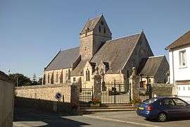 The church of Saint-Hilaire | |
 Méautis Location within Normandy region  Méautis | |
| Coordinates: 49°16′42″N 1°17′59″W / 49.2784°N 1.2997°WCoordinates: 49°16′42″N 1°17′59″W / 49.2784°N 1.2997°W | |
| Country | France |
| Region | Normandy |
| Department | Manche |
| Arrondissement | Saint-Lô |
| Canton | Carentan |
| Intercommunality | Carentan-en-Cotentin |
| Government | |
| • Mayor (2008–2014) | Marie-Christine Mette |
| Area1 | 16.98 km2 (6.56 sq mi) |
| Population (2006)2 | 651 |
| • Density | 38/km2 (99/sq mi) |
| Time zone | UTC+1 (CET) |
| • Summer (DST) | UTC+2 (CEST) |
| INSEE/Postal code | 50298 /50500 |
| Elevation |
0–29 m (0–95 ft) (avg. 42 m or 138 ft) |
|
1 French Land Register data, which excludes lakes, ponds, glaciers > 1 km2 (0.386 sq mi or 247 acres) and river estuaries. 2 Population without double counting: residents of multiple communes (e.g., students and military personnel) only counted once. | |
Méautis is a commune in the Manche department in Normandy in northwestern France.
World War II
After the liberation of the area by Allied Forces in 1944, engineers of the Ninth Air Force IX Engineering Command began construction of a combat Advanced Landing Ground outside of the town. Declared operational on 17 August, the airfield was designated as "A-17", it was used by the 50th Fighter Group which flew P-47 Thunderbolts until early September when the unit moved into Central France. Afterward, the airfield was closed.[1][2]
See also
References
- ↑ Johnson, David C. (1988), U.S. Army Air Forces Continental Airfields (ETO), D-Day to V-E Day; Research Division, USAF Historical Research Center, Maxwell AFB, Alabama.
- ↑ Maurer, Maurer. Air Force Combat Units of World War II. Maxwell AFB, Alabama: Office of Air Force History, 1983. ISBN 0-89201-092-4.
| Wikimedia Commons has media related to Méautis. |
This article is issued from
Wikipedia.
The text is licensed under Creative Commons - Attribution - Sharealike.
Additional terms may apply for the media files.