Nakuru County
| Nakuru County | |||
|---|---|---|---|
| County | |||
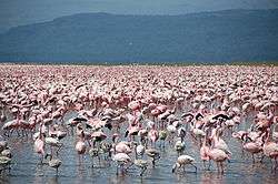 Flamingos at Lake Nakuru | |||
| |||
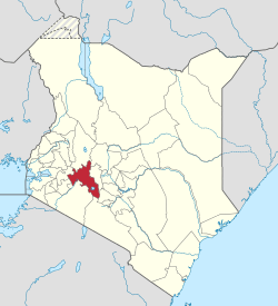 Location of Nakuru County in Kenya | |||
| Coordinates: 0°30′S 36°0′E / 0.500°S 36.000°ECoordinates: 0°30′S 36°0′E / 0.500°S 36.000°E | |||
| Country |
| ||
| Formed | 4 March 2013 | ||
| Capital and largest town | Nakuru | ||
| Other towns | Naivasha | ||
| Government | |||
| • Governor | Lee Kinyanjui | ||
| Area | |||
| • Total | 7,509.5 km2 (2,899.4 sq mi) | ||
| Population (2009) | |||
| • Total | 1,603,325[1] | ||
| Time zone | UTC+3 (EAT) | ||
| Website |
nakuru | ||

Nakuru County is a county in Kenya. The capital and largest town is Nakuru, although Naivasha is another major significant urban centre. With a population of 1,603,325[1] (2009 census), it is the fourth largest county in Kenya after Nairobi, Kakamega and Kiambu in that order in terms of population. Nakuru County has an area of 2,325.8 km². Until 2013, it formed part of Rift Valley Province.
Sites of Interest
Nakuru County is home to Lake Nakuru, Lake Elmenteita and Lake Naivasha some of the Rift Valley soda lakes. Lake Nakuru is best known for its thousands, sometimes millions of flamingoes nesting along the shores. The surface of the shallow lake is often hardly recognisable due to the continually shifting mass of pink. The number of flamingos on the lake varies with water and food conditions and the best vantage point is from Baboon Cliff. Also of interest, an area of 188 km around the lake fenced off as a sanctuary to protect Rothschild giraffe and black rhinos.
Other sites of interest around Nakuru include Menengai Crater, an extinct volcano 2,490m (8,167 ft) high. The views of the crater itself, as well as the surrounding countryside, are spectacular.
Hyrax Hill Prehistoric Site, discovered by the Leakeys in 1926, is considered a major Neolithic and Iron Age site. The adjoining museum features finds from various nearby excavations.
The second largest surviving volcanic crater in the world, the Menengai Crater is 2,242 meters above sea level at its highest point. The crater plunges 483 m down from the rim and the summit is accessible by foot or vehicle 8 km from the main road. The mountain is also surrounded by a nature reserve.
The Rift Valley Institute of Science and Technology is a tourist attraction. It is a giant institute established in 1979 by the leaders and people of Rift Valley.
Urban Areas
Surrounding towns include Lanet, which lies approximately 10 km from Nakuru is predominantly a residential town and is home to an army base. Njoro lies 20 km from Nakuru and is a small agricultural town with a local university aimed at promoting agricultural development in Kenya, namely Egerton University (est. 1934).
Urban Centres
| Town | Type | Population (2009) | Rank in Kenya (Population Size) |
|---|---|---|---|
| Nakuru | Municipality | 307,990 | 4 |
| Naivasha | Municipality | 169,142 | 9 |
| Molo | Town | 40,651 | 60 |
| Gilgil | Town | 35,293 | 69 |
| Njoro | Town | 23,551 | 82 |
| Mai Mahiu | Town | 11,230 | 112 |
| Subukia | Town | 7,309 | 139 |
| Dundori | Town | 5,221 | 166 |
| Salgaa | Town | 4,740 | 174 |
| Mau Narok | Town | 4,357 | 178 |
| Bahati | Town | 3,833 | 184 |
| Rongai | Town | 2,215 | 213 |
| Olenguruone | Town | 2,119 | 214 |
* 2009 census. Source:[2]

.jpg)
| Division | Population* | Urban pop.* | Headquarters |
|---|---|---|---|
| Bahati | 143,714 | 6,018 | Dundori |
| Elburgon | 65,314 | 23,881 | Elburgon |
| Gilgil | 91,929 | 18,805 | Gilgil |
| Kamara | 42,281 | 1,452 | Mau Summit |
| Keringet | 59,863 | 953 | Keringet |
| Kuresoi | 40,924 | 0 | |
| Lare | 27,727 | 0 | |
| Mauche | 15,391 | 0 | |
| Mau Narok | 29,916 | 3,321 | Mau Narok |
| Mbogoini | 59,510 | 228 | Subukia |
| Molo | 31,935 | 17,188 | Molo |
| Naivasha | 158,679 | 36,023 | Naivasha |
| Nakuru Municipal | 231,262 | 212,162 | Nakuru |
| Njoro | 79,123 | 15,635 | Njoro |
| Olenguruone | 32,030 | 509 | Olenguruone |
| Rongai | 77,441 | 2,163 | Rongai |
| Total | 1,187,039 | 338,338 | - |
| * 1999 census. Sources:[3][4] | |||
The county has eleven constituencies:
- Naivasha Constituency represented by Hon. John Kihagi, The National Alliance Party (TNA) a member of Jubilee Coalition
- Nakuru Town West Constituency represented by Hon. Samuel Arama, The National Alliance Party (TNA) a member of Jubilee Coalition
- Nakuru Town East Constituency represented by Hon. David Gikaria, The National Alliance Party (TNA) a member of Jubilee Coalition
- Kuresoi South Constituency Hon. Zakayo Cheruiyot, United Republican Party (URP) a member of Jubilee Coalition
- Kuresoi North Constituency Hon. Moses Cheboi, United Republican Party (URP) a member of Jubilee Coalition
- Molo Constituency represented by Hon. Jacob Waweru Macharia, The National Alliance Party (TNA) a member of Jubilee Coalition
- Rongai Constituency represented by Hon. Raymond Kipruto Moi, Kenya African National Union (KANU), a member of Amani coalition
- Subukia Constituency represented by Hon. Nelson Gachuiya, The National Alliance Party (TNA), a member of Jubilee Coalition
- Njoro Constituency represented by Hon. Joseph Nganga Tiuna, The National Alliance Party (TNA), A member of Jubilee Coalition
- Gilgil Constituency represented by Hon. Nderitu Mathenge, The National Alliance Party (TNA) a member of Jubilee Coalition
- Bahati Constituency represented by Hon. Onessmus Kimani Ngunjiri, The National Alliance Party (TNA) a member of Jubilee Coalition
Nakuru County was seen as the epicenter of violence in the aftermath of the disputed 2007 Presidential Elections which left over 1,100 people dead and over 350,000 displaced nationwide
Nakuru County Peace Accord
The Nakuru County Peace Accord (or “Rift Valley Peace Accord”) refers to the peace agreement signed on 19 August 2012 between elders of the Agikuyu (see also Kikuyu) and Kalenjin communities as well as other ethnic groups of Kenya.[5]
The agreement was designed to address sources of ethnic conflict and a history of violence in the rift valley region of Kenya.[6] It was signed following a 16 month-long peace process led by the National Cohesion and Integration Commission and the National Steering Committee on Peace Building and Conflict Management
Notable residents
- Carole Kariuki, businesswoman and executive [7]
See also
| Wikimedia Commons has media related to Nakuru County. |
References
- 1 2 "Kenya Census 2009 - Census - Kenya". Scribd.
- ↑ "Archived copy" (PDF). Archived from the original (PDF) on 24 February 2013. Retrieved 24 February 2013.
- ↑ "Archived copy" (PDF). Archived from the original (PDF) on 28 September 2007. Retrieved 28 September 2007.
- ↑ "Archived copy". Archived from the original on 18 July 2011. Retrieved 18 July 2011.
- ↑ "Media Breakfast Meeting on Nakuru Peace Accord - Speech by NCIC Chairman, Dr. Mzalendo Kibunjia". National Cohesion and Integration Commission. 7 June 2012. Archived from the original on 20 December 2014. Retrieved 20 December 2012.
- ↑ Wairimu Nderitu, Alice (2014). From the Nakuru County Peace Accord to Lasting Peace (PDF). Centre for Humanitarian Dialogue.
- ↑ KEPSA (18 November 2017). "Carole Kariuki, Chief Executive Officer, Kenya Private Sector Alliance: Short Biography". Nairobi: Kenya Private Sector Alliance (KEPSA). Retrieved 18 November 2017.
External links
- Nakuru County Directory Kenya
- Office for the Coordination of Humanitarian Affairs – Kenya AdminLevels 1-4