Kericho

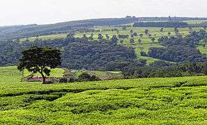
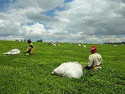
Kericho is the biggest town in Kericho County located in the highlands west of the Kenyan Rift Valley. Standing on the edge of the Mau Forest, Kericho has a warm and temperate climate making it an ideal location for agriculture and in particular, the large scale cultivation of tea.
The town is strategically located along Kenya's western tourism circuit with access to Lake Victoria, the Maasai Mara National Reserve and Ruma National Park.
As of the 1999 census, the town has a population of 150,000.[1] Kericho is the home town of the Kipsigis, who are a part of the Kalenjin people.
History and culture
The etymology of Kericho is unclear. One theory has it that it was home to the region's first hospital, built by the colonial British at the start of the 20th Century. This is in reference to kerichek the word for medicine in the Kipsigis language.
Other theories have it that the town was named for a local medicine man called Kipkerich or after a Maasai chief, Ole Kericho who was killed in the 18th Century by the Abagusii.
Kericho hosts Africa's largest Sikh Gurudwara[2] and the second largest Catholic cathedral in Kenya.[3]
Gurdwara Sahib is built on the site of the home and workshop of Kericho Wagon Works founder Sant Baba Puran Singh Ji of Kericho. The site is currently a place of worship for the Sikh community and a museum gazetted by the Government of Kenya as a place of spiritual significance.
It is dedicated to the memory of Sant Baba Puran Singh Ji, founder of the international charitable organization, Guru Nanak Nishkam Sewak Jatha which promotes the spirit and practice of selfless service ("nishkam sewa") in the name of Guru Nanak Dev Ji, the founder of the Sikh faith.
Chandarana Records a pioneer of Benga music and the Kenyan music recording industry is based in Kericho town.
Kericho is home to Olympic winning long distance athletes and hosts Zoo Kericho F.C. a football club competing in the Kenyan Premier League and Kericho R.F.C. competing in the Nationwide League.[4]
Friends of The Elderly (FOTE) is a community based organization in Kericho which focusses on caring for the elderly people in the society. The group has through the years grown from an assembly of friends to a government registered and recognized organization complete with a proper leadership in place. It is a first of firsts in the county and country at large.
Other notable places of interest include Chagaik Arboretum, Chelimo Arboretum, Tagabi Arboretum, Uhuru Garden and the vast scenic tea estates with high ground view points.
Government
Kericho town is the headquarters of Kericho county, which is itself made up of six constituencies/sub-counties including Bureti, Belgut, Ainamoi, Soin/Sigowet, Kipkelion East, and Kipkelion West.
Transport
Kericho is accessible by road through the B1 road (Kenya) that links Mau-Summit, Kericho to Kisumu and Busia. In addition, the C25 Kapsoit-Sondu road connects Kericho to the A1 road (Kenya) linking Isebania to Lokichoggio through Kisumu and Kitale.[5]
Regular public bus (matatu) services connect Kericho to nearby smaller towns such as Molo, Kaplong, Sotik, Bomet and Narok and also major cities of Kisumu and Nairobi.
The Nakuru-Kisumu railway line passes through Kericho County with railway stations at Mau Summit, Londiani, Kedowa, Lumbwa, Kipkelion and Fort Ternan. Fort Ternan was previously used as a halfway point for passenger and goods trains between Nakuru and Kisumu.[6]
Regular air transport services are not available in Kericho. Kericho Airport is the official airstrip servicing the town and surrounding areas. Private airstrips operated by the tea estates have a more regular use for purposes of crop spraying.[7]
Communication and media
Kericho town has access to a high-speed fiber-optic Internet connection, fixed line, and mobile telecommunications.
There are several local FM radio stations including Kass FM, Chamgei FM, KBC Kitwek FM, Radio Injili, Sayare Radio, Light and Life FM, Sema Radio and The Just FM.
Tertiary education
Kericho hosts several satellite campuses and colleges providing certificate, diploma and degree courses.
- University of Kabianga
- Kenya Highlands Evangelical University run by the Africa Gospel Church
- Kenyatta University
- The University of Nairobi
- Mospen Institute of Development Studies(MIDS): Offers Diploma, Certificate, Artisan, Short Courses & Computer Packages
- Kericho Teachers Training College offers degree courses under agreement with Moi University
- Eland College run jointly by Kabarak University and Eland Schools
- South Rift International College (SORICO)
- African Institute of Research and Development Studies (AIRADS)
- Niskam Saint Puran Singh Institute (NSPSI)
- Kericho Technical Institute
- Kericho School of Professional Studies
- Kenya Institute of Management
- Rift valley institute of business studies
Secondary education
Kericho is home to two national secondary schools: Kipsigis Girls High School and Kabianga Boys Secondary School as well as Kericho High School.
Religion
Kericho is home to followers of the Africa Gospel Church, Seventh Day Adventists, Catholics, Sikhs, Muslims, Hindus, and Anglicans.
Notable people
- Paramount chief Cheborge arap Tengecha
- Ayub Siele, former Kericho Mayor(Connected Kericho to Portsmouth Virginia, founded The Kericho Water and Sewerage Company by sourcing for outside financing from Europe. He is also the Former National(Kenyan Chapter) Chairman of The International Planned Parenthood Foundation (Family Planning Kenya)
- Sant Baba Puran Singh Ji
- Dr. Taitta Toweett
- Joginder Singh
- Hannington Apudo, the first indigenous military pilot in the Kenya Air Force
- Noah arap Too
- Wilson Kiprugut
- Moses Kiprono arap Keino
- Joyce Chepchumba
- Edwin Soi
- David Kimutai Too
- Franklin Bett
- Dr Baldev Singh, National Teacher of the Year for Innovation in Education in the UK in 2004 is Kericho-born
- Dr Jeevan Kular
- Bob Mburu
- James R. Ryan (b.1968), historical and cultural geographer, currently in the Research Department of the V&A where he is Head of Programme (V&A) for the MA History of Design. He is also Associate Professor of Historical and Cultural Geography at the University of Exeter, UK.
References
- ↑ "The National Treasury" (PDF). Treasury.go.ke. 2015-07-09. Retrieved 2015-12-06.
- ↑ http://www.allaboutsikhs.com/world-gurudwaras/guru-nanak-nishkam-sewak-jatha-kericho-kenya
- ↑ http://www.the-star.co.ke/news/2015/05/25/cathedral-opened-in-kericho_c1140945
- ↑ http://shujaapride.com/teams/team/89/Kericho-RFC/
- ↑ "Archived copy". Archived from the original on 2016-01-30. Retrieved 2016-01-25.
- ↑ http://www.mccrow.org.uk/EastAfrica/EastAfricanRailways/NairobiKisumu.htm
- ↑ http://aeroclubairfields.com/go.php?mod=public&loco=airstrips