Machakos County
| Machakos County | |||
|---|---|---|---|
| County | |||
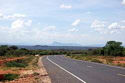 Road in Machakos County showing the landscape | |||
| |||
| Nickname(s): Macha | |||
| Motto(s): "the Place to be" | |||
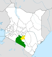
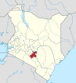 Location in Kenya | |||
| Coordinates: 01°14′S 37°23′E / 1.233°S 37.383°E | |||
| Country |
| ||
| Formed | 4 March 2013 | ||
| Capital | Machakos | ||
| Government | |||
| • Governor | Alfred Mutua | ||
| • Deputy Governor | Francis Maliti | ||
| • Senator | Boniface Kabaka | ||
| • Women Representative | Joyce kamene | ||
| Area | |||
| • Total | 5,952.9 km2 (2,298.4 sq mi) | ||
| Elevation | 1,138 m (3,734 ft) | ||
| Population (2009) | |||
| • Total | 1,098,584 [1] | ||
| Time zone | UTC+3 (EAT) | ||
| Website | machakosgovernment.com | ||
Machakos County is a county of Kenya. Its capital is Machakos. Its largest town is Machakos, the country's first administrative headquarters. The county had a population of 1,098,584 as of 2009.[1] The county borders Nairobi and Kiambu counties to the west, Embu to the north, Kitui to the east, Makueni to the south, Kajiado to the south west, and Muranga and Kirinyaga to the north west.
Office of the governor
The office of the governor of Machakos was created on 27 March 2013. Alfred Mutua, the incumbent, is the inaugural holder of the office.[2]
Education
There are many primary schools in Machakos County, including Machakos Primary School and Machakos Academy.
Machakos County has giant secondary schools such as Machakos School (boys), Machakos Girls' School, Mumbuni Boys' Secondary School, Mumbuni Girls' Secondary School, Masii Boys' Secondary School, Tala Girls' School, Matungulu Girls' High School and Kabaa High School (boys), which boasts of a castle which was left behind by Christian missionaries. This castle is now a museum.
Kwa Nthanze Secondary School, which is also found in Machakos County, is famous for its volleyball championship in the country.
Universities and colleges within Machakos County include Machakos University,[3] Scott Theological University, South Eastern Kenya University (SEKU), St. Paul's University, African Training Center for Research and Technology,[4] Century Park College, Machakos Institute of Technology, and Machakos Technical Training Institute for the Blind.
Climate
The local climate is semi-arid with hilly terrain and an altitude of 1000 to 2100 metres above sea level.
Tourist-related activities include camping, hiking safaris, ecotourism and cultural tourism, dance and music festivals.[2]
Economy
Subsistence agriculture is mostly practiced with maize and drought-resistant crops such as sorghum and millet being grown due to the area's semi-arid state. The county also plays host to the open air market concept with major market days where large amounts of produce are traded. Fruits, vegetables and other food stuffs like maize and beans are sold in these markets.[2]
Future
The county is banking on projects such as the Konza Technology City, a new Machakos City[5] and its proximity to Nairobi County to boost output in the economy.
Services
| County | Stats for the county (percent) | ||||||||
|---|---|---|---|---|---|---|---|---|---|
| Literacy | 88 | ||||||||
| Attending school (15-18 Yrs) | 75.9 | ||||||||
| Paved roads | 6.9 | ||||||||
| Good roads | 26.9 | ||||||||
| Electricity access | 17 | ||||||||
|
Stats for the county | |||||||||
Source: USAid Kenya
Subdivisions
| Local authorities (councils) | |||
| Authority | Type | Population* | Urban pop.* |
|---|---|---|---|
| Machakos | Municipality | 144,109 | 28,891 |
| Mavoko (Athi River) | Municipality | 48,260 | 22,167 |
| Kangundo | Town | 187,389 | 9,122 |
| Matuu | Town | 44,922 | 5,321 |
| Masaku | County | 481,964 | 9,088 |
| * 1999 census. Source:[6] | |||
| Administrative divisions | |||
| Division | Population* | Urban pop.* | Headquarters |
|---|---|---|---|
| Kalama | 41,000 | 0 | |
| Kangundo | 91,238 | 3,786 | Kangundo |
| Kathiani | 95,096 | 2,929 | Mitaboni |
| Machakos Central | 143274 | 26,438 | Machakos |
| Masinga | 74,478 | 654 | Masinga |
| Matungulu | 99,731 | 4,734 | Tala |
| Mavoko | 48,936 | 19,177 | Athi River |
| Mwala | 89,211 | 2,708 | |
| Ndithini | 32,358 | 0 | |
| Yathui | 65,567 | 481 | Wamunyu |
| Yatta | 125,755 | 4913 | Matuu |
| * 1999 census. Sources:,,[7][8] | |||
The county has eight constituencies:
Nairobi Metro
Machakos County is within Greater Nairobi which consists of 4 out of 47 counties in Kenya, but the area generates about 60% of the nation's wealth.[9][10] The counties are:
| Area | County | Area (km2) | Population Census 2009 | Cities/towns/municipalities in the county |
|---|---|---|---|---|
| Core Nairobi | Nairobi County | 694.9 | 3,138,369 | Nairobi |
| Northern Metro | Kiambu County | 2,449.2 | 1,623,282 | Kiambu, Thika, Limuru, Ruiru, Karuri, Kikuyu |
| Southern Metro | Kajiado County | 21,292.7 | 687,312 | Kajiado, Olkejuado, Bissil, Ngong, Kitengela, Kiserian, Ongata Rongai |
| Eastern Metro | Machakos County | 5,952.9 | 1,098,584 | Kangundo-Tala, Machakos, Athi River |
| Totals | Nairobi Metro | 30,389.7 | 6,547,547 |
Source: NairobiMetro/ Kenya Census
Statistics
Nairobi Metro
Urbanisation
| County | Urbanisation in Nairobi Metro (percent) | ||||||||
|---|---|---|---|---|---|---|---|---|---|
| Nairobi County | 100 | ||||||||
| Kiambu County | 60.8 | ||||||||
| Machakos County | 52 | ||||||||
| Kajiado County | 41.4 | ||||||||
32.3 | |||||||||
|
Urbanisation by county within Nairobi Metro | |||||||||
Source: OpenDataKenya
Wealth/poverty Level
| County | Poverty level in Nairobi Metro (percent) | ||||||||
|---|---|---|---|---|---|---|---|---|---|
| Kajiado County | 11.6 | ||||||||
| Kiambu County | 21.8 | ||||||||
| Nairobi County | 22 | ||||||||
| Machakos County | 59.6 | ||||||||
45.9 | |||||||||
|
Poverty level by county | |||||||||
Source: OpenDataKenya Worldbank
South Eastern Kenya Region
Urbanisation
| County | Urbanisation in South Eastern Kenya (percent) | ||||||||
|---|---|---|---|---|---|---|---|---|---|
| Machakos County | 52 | ||||||||
| Kitui County | 13.8 | ||||||||
| Makueni County | 11.8 | ||||||||
32.3 | |||||||||
|
Urbanisation by county in South Eastern Kenya | |||||||||
Source: OpenDataKenya
Wealth/poverty Level
| County | Poverty Level in South Eastern Kenya (percent) | ||||||||
|---|---|---|---|---|---|---|---|---|---|
| Machakos County | 59.6 | ||||||||
| Kitui County | 63.1 | ||||||||
| Makueni County | 64.1 | ||||||||
45.9 | |||||||||
|
Poverty level by county | |||||||||
Source: OpenDataKenya Worldbank
See also
References
- 1 2 "Kenya Census 2009". Scribd.com. Retrieved 10 December 2013.
- 1 2 3 "Official Website". Machakos Government. Retrieved 10 December 2013.
- ↑ Machakos University. "Contact Us". Retrieved 29 March 2018.
- ↑ African Training Center for Research and Technology
- ↑ Machakos City
- ↑
- ↑ Archived 16 June 2007 at the Wayback Machine.
- ↑ Archived 28 September 2006 at the Wayback Machine.
- ↑
- ↑
External links
Nairobi metropolitan area | ||
|---|---|---|
Population - 7.8 million | ||
| Counties |  | |
| Major city 3.8 million | ||
| Urban Centres over 200K | ||
| Other major Urban Centres | ||
| Future developments | ||