Marsabit County
| Marsabit County | |||
|---|---|---|---|
| County | |||
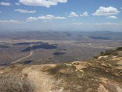 Marsabit Landscape | |||
| |||
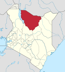 Location of Marsabit County in Kenya | |||
| Coordinates: 2°19′N 37°58′E / 2.317°N 37.967°ECoordinates: 2°19′N 37°58′E / 2.317°N 37.967°E | |||
| Country |
| ||
| Formed | March 4, 2013 | ||
| Capital | Marsabit | ||
| Largest town | Moyale | ||
| Other towns | Sololo | ||
| Government | |||
| • Governor | Ukur Yatani | ||
| Area | |||
| • Total | 66,923.1 km2 (25,839.2 sq mi) | ||
| Population (2009)[1] | |||
| • Total | 291,166 | ||
| • Density | 4.4/km2 (11/sq mi) | ||
| Time zone | UTC+3 (EAT) | ||
| Website |
marsabit | ||

Marsabit County (up to 2010 Marsabit District) is a county of Kenya. Covering a surface area of 66.923,1 square kilometres Marsabit is the largest county in Kenya. Its capital is Marsabit and its largest town Moyale. The county has a population of 291,166.[1]
Geography
The county is located in northern Kenya. It borders the eastern shore of Lake Turkana. The Chalbi Desert makes up much of the center region of the county, and mount Marsabit is a major feature of the eastern section.
Subdivisions
Marsabit County has only one local authority, Marsabit county council. The county is divided into six administrative divisions:
| Division | Population* | Urban pop.* | Headquarters |
|---|---|---|---|
| Central | 25,100 | 10,619 | Marsabit |
| Gadamoji | 12,345 | 0 | |
| Laisamis | 24,011 | 2,817 | Laisamis |
| Loiyangalani | 16,965 | 1,054 | |
| Maikona | 19,518 | 0 | Maikona |
| North Horr | 23,539 | 2,343 | North Horr |
| Total | 121,478 | 16,833 | - |
| * 1999 census. Sources:,,[2][3] | |||
Electoral constituencies
The county has four constituencies:
References
- 1 2 "Kenya Census 2009 - Census - Kenya". Scribd. Retrieved 20 April 2018.
- ↑ "Archived copy" (PDF). Archived from the original (PDF) on 28 September 2007. Retrieved 2007-11-26.
- ↑ "Archived copy". Archived from the original on 28 September 2006. Retrieved 2007-11-27.
External links
- http://softkenya.com/county/marsabit-county/ Marsabit County
- http://www.aridland.go.ke/bulletins/August%202006-Marsabit.pdf%5Bpermanent+dead+link%5D
This article is issued from
Wikipedia.
The text is licensed under Creative Commons - Attribution - Sharealike.
Additional terms may apply for the media files.