Kilifi County
| Kilifi County | |||
|---|---|---|---|
| County | |||
 | |||
| |||
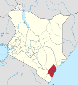 Location in Kenya | |||
| Country | Kenya | ||
| Formed | March 4, 2013 | ||
| Capital | Kilifi | ||
| Government | |||
| • Governor | Amason Kingi | ||
| Area | |||
| • Total | 12,245.9 km2 (4,728.2 sq mi) | ||
| Population (2009) | |||
| • Total | 1,109,735 [1] | ||
| Time zone | UTC+3 (EAT) | ||
| Website | kilifi.go.ke | ||

Kilifi County is a county of Kenya. It was formed in 2010 as a result of a merger of Kilifi District and Malindi District. Its capital is Kilifi and its largest town is Malindi. The county has a population of 1,109,735.[2] It covers an area of 12,245.90 km2 (4,728.17 sq mi). Kilifi county forms a constituency when electing a senator and a woman representatives of Kenyan Parliament and Senate. It also elects its own governor who is the county leader.
The county is represented in parliament by seven legislators, one woman representative and a Senator in senate. The county also has 35 ward representatives.
The county is located north and northeast of Mombasa. Kilifi has fewer tourists than Mombasa County, but there are some tourists beaches in Kikambala, Watamu, Malindi and Kilifi.
Overview
Tourism and fishing in Kilifi are major economic activities due to its proximity to the Indian Ocean. The county has some of the best beaches and popular resorts and hotels. Other attractions include historical sites such as the Mnarani ruins that date back to between the fourteenth and seventeenth century.[3]
The county has a strong industrial sector with the Mabati Rolling Mill and the Athi River Cement Factory contributing heavily to the region’s economy both in employment provision and income generation.
Opportunities exist in agriculture, particularly dairy and crop farming thanks to fertile soils and a good weather pattern. The Kilifi County Minister for Agriculture, Livestock and Fisheries is Mwalimu Menza. The county had a successful cashew nut milling industry and opportunities exist in its revival.
Demographic
1999 Census figure
| Local authorities (councils) | |||
| Authority | Type | Population* | Urban pop.* |
|---|---|---|---|
| Kilifi | Town | 74,050 | 30,394 |
| Mariakani | Town | 57,984 | 10,987 |
| Kilifi County | County | 412,269 | 28,266 |
| Total | – | 544,303 | 69,647 |
| * 1999 census. Source: | |||
| Administrative divisions | |||
| Division | Population* | Urban pop.* | Headquarters |
|---|---|---|---|
| Bahari | 90,009 | 26,862 | Kilifi |
| Bamba | 35,852 | 1,307 | Bamba |
| Chonyi | 47,138 | 0 | |
| Ganze | 33,207 | 0 | Ganze |
| Kaloleni | 197,033 | 13,964 | Kaloleni |
| Kikambala | 97,898 | 23,997 | Mtwapa |
| Vitengeni | 43,159 | 0 | Vitengeni |
| Total | 544,303 | 66,130 | |
| * 1999 census. Sources: , , | |||
Representatives
The county has seven constituencies:[4]
| Constituency | Popln 2009 Census | Area | No of wards | Wards |
|---|---|---|---|---|
| Kilifi North Constituency | 207,587 | 405 | 7 | Tezo, Sokoni, Kibarani, Dabaso,Matsangoni, Watamu, Mnarani. |
| Kilifi South Constituency | 171,607 | 401 | 5 | Junju, Mwarakaya, Shimo la Tewa, Chasimba,Mtepeni |
| Kaloleni Constituency | 139,302 | 651 | 4 | Mariakani, Kayafungo, Kaloleni, Mwanamwinga |
| Rabai Constituency | 113,622 | 241 | 4 | Mwawesa, Ruruma, Kambe-Ribe, Rabai/Kisurutuni |
| Ganze Constituency | 137,664 | 2,942 | 4 | Ganze,Bamba, Jaribuni, Sokoke |
| Malindi Constituency | 162,712 | 627 | 5 | Jilore, Kakuyuni, Ganda, Malindi Town, Shella |
| Magarini Constituency | 177,241 | 6,979 | 6 | Maarafa, Magarini, Gongoni, Adu, Garashi,Sabaki |
| 1,109,735 | 12,245.90 | 35 |
Bahari Constituency which was formed 1988 was disbanded in 2013 by creation of two new constituencies, Kilifi North Constituency and Kilifi South Constituency
Image gallery
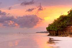 Diani Beach sunrise
 Sun rises over the Indian Ocean at Malindi