Baringo County
| Baringo County | |||
|---|---|---|---|
| County | |||
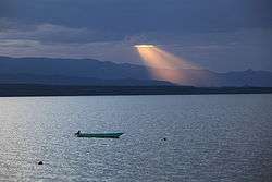 Sunset over Lake Baringo, Baringo County, Kenya | |||
| |||
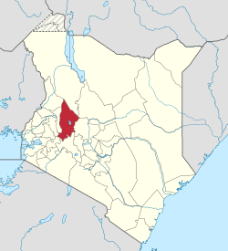 Location in Kenya | |||
| Country |
| ||
| Formed | 4 March 2013 | ||
| Capital | Kabarnet | ||
| Government | |||
| • Governor | Stanley Kiptis | ||
| Area | |||
| • Total | 11,075.3 km2 (4,276.2 sq mi) | ||
| Population (2009) | |||
| • Total | 555,561[1] | ||
| Time zone | UTC+3 (EAT) | ||
| Website | baringo.go.ke | ||

Baringo County is one of the 47 Counties of Kenya. It is located in the former Rift Valley Province. Its headquarters and largest town is Kabarnet. The county is home to Lake Baringo.
Geographical location
Baringo bounded by Turkana County and West Pokot County to the North, Samburu County and Laikipia County to the East, Nakuru County and Kericho County to the South, Uasin Gishu County to the South West and Elgeyo Marakwet County to the West. It covers an area of 8,655s square km. Baringo County lies between Latitudes 00 degrees 13" South and 1 degree 40" north and Longitudes 35 degrees 36" and 36" degrees 30" East.
Demographics
The county has a population of 555,561[1] (2009 census) and an area of 11,075.3 km2 (4,276.2 sq mi).
Religion and ethnicities
The county is occupied by the Tugen, Pokot and Njemps. A sizeable population of Nubians is found in Eldama-Ravine. Christianity is the most practiced religion in the county. Baringo county has many tribes including Tugens, Njemps, Pokots, Turkanas, Kikuyus, Numbians and Kisiis
County government
The County Governor is Stanley Kiptis and is deputized by Jacob Kurui Chepkwony. The Senator is Gideon Moi while the County Women is Gladwell Tungo. The County Executive Committee consists of the following:
| CEC Member | Docket |
|---|---|
| Mrs.Scola Jepkesei Kimeliy | Industrialization, Commerce Tourism and Enterprise Development |
| Mrs. Lilian Sadalla | Land, Housing and Urban Planning |
| Mr. Edwin Riamangura | Youth, Gender, Labour and Social Services |
| Mr. .Job Kibei Tomno | Water and Irrigation |
| Ms. Caroline Lentupuru | Environment and Natural Resources |
| mr Philemon Rono | Transport and Infrastructure |
| Mrs. Emily Kibet | Education |
| Mr. Lukah Rotich | Agriculture, Livestock and Fisheries |
Economics
The economy of the County is mainly agro-based. The main food crops grown are maize, pigeon peas, beans, Irish potatoes, sweet potatoes, sorghum, cassava and finger millet while the cash crops are coffee, cotton, macadamia and pyrethrum.[2] Livestock products include honey, beef, mutton as well as hides and skins. However, little value addition is done to these products.
Urbanization
Major urban centres in the county are; Kabarnet, Eldama Ravine, Marigat, Mogotio, Kabartonjo and Chemolingot
Tourism and Wildlife
Major attraction sites are[3]
1. Lake Bogoria and Kapedo hotsprings.
2. Lake Baringo
4, Kabarnet National Museum and Kipsaraman Community Museum 5.ruko conservancy Lake Bogoria Game Reserve is home to rare kudus, antelopes, zebras, leopards, cheetahs, hyenas, mongoose, monkeys, baboons and jackals. At the shores of Lake Bogoria are more than two millions lesser flamingoes, 350 bird species.
Lake Baringo Snake Park has many snake species such as the Black Mamba, Puff Adder, Boomslang and Spitting Cobra, Monitor Lizards, Crocodiles and Tortoises.
Major tourist hotels in the county are;
1. Lake Bogoria Hotel and Spa Resort.
2. Kabarnet Hotel, Kabarnet
3. Sinkoro Hotel Ltd, Kabarnet
4. Soi Safari lodge
5. Sportsline Hotel, Kabarnet
6. Taidy’s Restaurant, Eldama Ravine
7. Kibelion Hotel, Emining
Education
Kabarnet town hosts a number of university campuses including those of Mount Kenya University and Egerton University and Kisii University
Health
Kabarnet County Referral Hospital is the largest and best public hospital in the county.
Transport and infrastructure
The county headquarters is linked to Nakuru and Eldoret by class C roads which fall under the Kenya National Highways Authority (KENHA).
In January 2016, Fly-SAX began twice-weekly flights between Lake Baringo Airport and Nairobi–Wilson, becoming the first airline to serve the airport.[4]
Constituencies
The county has six constituencies: Baringo Central Constituency, Baringo South Constituency, Baringo North Constituency, Eldama Ravine Constituency, Mogotio Constituency, and Tiaty Constituency.
Villages and settlements
References
https://web.archive.org/web/20140322145500/http://baringo-county.kbo.co.ke/
External links
- https://web.archive.org/web/20130511020558/https://opendata.go.ke/facet/counties/Baringo
- http://www.aridland.go.ke/districts.asp?DistrictID=8%5Bpermanent+dead+link%5D
- http://www.reliefweb.int/rw/RWB.NSF/db900SID/VBOL-6TNC5G?OpenDocument
- Map of the District
- Baring County
Coordinates: 0°40′N 36°00′E / 0.667°N 36.000°E
- 1 2 https://www.scribd.com/doc/36672705/Kenya-Census-2009
- ↑ "Agriculture, Livestock and Fisheries". www.baringo.go.ke. Archived from the original on 3 February 2014. Retrieved 2014-02-07.
- ↑ "Industrialization, Commerce, Tourism & Enterprise Development". www.baringo.go.ke. Archived from the original on 3 February 2014. Retrieved 2014-02-07.
- ↑ "Fly SAX starts flights to Lake Baringo". African Aerospace. 14 December 2015. Retrieved 5 February 2016.