Wajir County
| Wajir County | |||
|---|---|---|---|
| County | |||
| |||
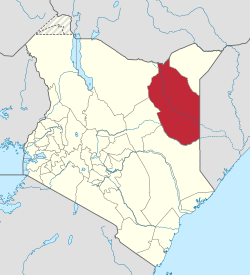
 Location of Wajir County in Kenya | |||
| Coordinates: 1°44′50″N 40°04′08″E / 1.74722°N 40.0689°ECoordinates: 1°44′50″N 40°04′08″E / 1.74722°N 40.0689°E | |||
| Country |
| ||
| Formed | March 4, 2013 | ||
| Capital and largest town | Wajir | ||
| Other towns | |||
| Government | |||
| • Governor |
| ||
| Area | |||
| • Total | 55,840.6 km2 (21,560.2 sq mi) | ||
| Population (2009)[1] | |||
| • Total | 661,941 | ||
| • Density | 12/km2 (31/sq mi) | ||
| Time zone | UTC+3 (EAT) | ||
| Website |
www | ||
Wajir County is a county in the former North Eastern Province of Kenya. Its capital and largest town is Wajir. The county has a population of 661,941[1] and an area of 55,840.6 km². Wajir County has only one local authority: Wajir county council. The county has six constituencies: Eldas, Tarbaj, Wajir North, Wajir West, Wajir East, and Wajir South. Wajir County is divided into fourteen administrative divisions:
| Division | Population* | Pop. density* | Area (km²) | Headquarters |
|---|---|---|---|---|
| Buna | 29,160 | 5 | x | Buna |
| Bute | 14,684 | 20 | x | Bute |
| Central | 51,006 | 22 | x | Wajir |
| Diff | 19,052 | 3 | x | |
| Eldas | 9,166 | 4 | x | |
| Griftu | 42,333 | 6 | x | |
| Gurar | 18,087 | 7 | x | Gurar |
| Habaswein | 27,467 | 6 | x | Habaswein |
| Hadado | 19,787 | 5 | x | |
| Kotulo | 23,016 | 9 | x | |
| Lafaley | 5,883 | 12 | x | |
| Sebule | 25,699 | 3 | x | |
| Tarbaj | 22,758 | 4 | x | Tarbaj |
| Wajir-Bor | 17,046 | 4 | x | |
| Total | 319,261 | 6 (average) | x | - |
| * 1999 census[2] | ||||
Villages and settlements
References
- 1 2 "Kenya Census 2009". Scribd.com. Retrieved 2017-07-17.
- ↑ "Status of Coverage of Communications Services" (PDF). www.cck.go.ke. Archived from the original (PDF) on 30 May 2009. Retrieved 17 July 2017.
This article is issued from
Wikipedia.
The text is licensed under Creative Commons - Attribution - Sharealike.
Additional terms may apply for the media files.

