Nanyuki
| Nanyuki | |
|---|---|
| Town | |
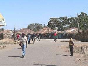
 Nanyuki main street | |
 Nanyuki Location in Kenya | |
| Coordinates: 0°01′N 37°04′E / 0.017°N 37.067°ECoordinates: 0°01′N 37°04′E / 0.017°N 37.067°E | |
| Country |
|
| County | Laikipia County |
| Government | |
| • Mayor of Nanyuki | Cllr. Isaac Mathenge |
| Population (2009) | |
| • Total | 49,233 |
Nanyuki is a market town in Laikipia County of Kenya lying northwest of Mount Kenya along the A2 road and at the terminus of the branch railway from Nairobi. It is situated just north of the Equator (0° 01' North). It was founded in 1907 by British settlers, some of whose descendants still live in and around the town. Nanyuki is currently the main airfield (airbase) of the Kenya Air Force. The British Army also keeps a base at The Nanyuki Show Ground (NSG) from where it conducts yearly desert and jungle training exercises on the mountain and in the arid areas to the north.
History
The town was started by British settlers during the early days of colonial Kenya in 1907. Some of their descendants still live in or around the town. Major Digby Tatham-Warter, a decorated veteran of Operation Market Garden, moved to Nanyuki after the war and lived on his farm until his death in 1993.[1] The market centre is famous for farms, ranches, game parks and wildlife conservancies in the region. It's also the base for people seeking to climb Mount Kenya, the most famous landmark in the country. The Equator line passes 6.5 km (4 mi) south of this town.
Climate
| Climate data for Nanyuki | |||||||||||||
|---|---|---|---|---|---|---|---|---|---|---|---|---|---|
| Month | Jan | Feb | Mar | Apr | May | Jun | Jul | Aug | Sep | Oct | Nov | Dec | Year |
| Average high °C (°F) | 25 (77) |
26 (79) |
25 (77) |
23 (74) |
23 (73) |
23 (74) |
22 (72) |
23 (73) |
24 (76) |
24 (75) |
23 (73) |
23 (74) |
24 (75) |
| Average low °C (°F) | 7 (45) |
8 (47) |
9 (49) |
11 (51) |
10 (50) |
9 (48) |
8 (47) |
8 (47) |
8 (46) |
8 (47) |
9 (49) |
8 (47) |
9 (48) |
| Average precipitation mm (inches) | 13 (0.5) |
23 (0.9) |
46 (1.8) |
119 (4.7) |
81 (3.2) |
50 (2) |
69 (2.7) |
66 (2.6) |
48 (1.9) |
64 (2.5) |
86 (3.4) |
38 (1.5) |
699 (27.5) |
| Source: Weatherbase[2] | |||||||||||||
Economy & Overview
Nanyuki municipality had an urban population of 49,233 in 2009.[3] Most members of the population earn their money through trade. Shops in the town supply many farms, ranches and game parks in a wide circle. Originally, most shops were owned by Indians, who still form a sizable part of the population. Climbers and backpackers visit Nanyuki on their way to or from Mount Kenya along the Sirimon and Burguret routes and many other tourists pass through the town. Nanyuki therefore has many hotels, of which Mount Kenya Safari Club and Sportsman’s Arms Hotel are the most prominent and best known. Other hotels include Lion’s Court, Equatorial Hotel, Mount Kenya Paradise Hotel and Joskaki Hotel. The oldest restaurant in town is The Marina and it is still fairly popular. Several years ago, a restaurant was opened south of Nanyuki built inside a huge tree. Named “Trout Tree Restaurant” its main attraction is obviously trout prepared in various ways. Patrons can also visit the trout breeding installation at the foot of the tree. Another notable restaurant is "Barneys" located at Nanyuki Civil Airfield, once the location of the No. 1340 Flight RAF, which flew Harvards during the Mau Mau Uprising.
There is little large-scale industry in Nanyuki. There used to be a textile factory, Mount Kenya Textile (Mountex) Mills. The British management deteriorated over the years, which largely contributed to its bankruptcy in 1978. Years later, the factory, which had remained more or less intact, was bought by an Asian businessman, an inhabitant of Nanyuki. Some textile was produced. The factory eventually closed due to cheap imports and outdated machinery and finally was looted to the ground.[4] There have also been a number of sawmills in Nanyuki. However, with the almost total ban on tree felling on Mount Kenya, these either closed down or are now eking out a difficult existence.[5] Recently, large horticultural operations have come to Nanyuki.
A park lies in the centre of the town and two rivers, the Nanyuki and Liki Rivers, pass through it. The Equator passes through the southern part of Nanyuki. One crosses it when approaching Nanyuki on the A2 from the south. This spot is popular with tourists who have themselves photographed there. Some people are usually at hand to show them the supposed effect of the Coriolis force, which they say makes draining water swirl clockwise or anticlockwise depending on whether one is on the northern or southern hemisphere, though as noted in the article about the Coriolis force, the effect is detectable only in the laboratory and the "demonstrations" at the Equator are merely engaging diversions.
Tourism
Nanyuki can be reached by air. Its airport lies 6.5 km (4 mi) south of the town along the highway to Nairobi and is served by light aircraft. There are regular flights operated by Air Kenya, Safarilink and Fly SAX, which is very convenient for businessmen and tourists. The town is also reachable using the all-weather road from Nairobi. Tourists can visit a number of parks and reserves in the vicinity of Nanyuki, the most obvious one being Mount Kenya National Park. The Mount Kenya Wildlife Conservancy and the Fairmont Mount Kenya Safari Club attract large numbers of tourists to the area seeking a luxury safari experience. The hotel holds 120 luxury rooms with views of Mount Kenya alongside the Mount Kenya Wildlife Conservancy which aims to breed and reintroduce the endangered bongo back into Mount Kenya.[6] Others are Ol Pejeta Conservancy, Lewa Wildlife Conservancy, Samburu National Reserve and Shaba National Reserve.
The creative space, restaurant and bar at the Lily Pond Arts Centre is a wonderful retreat.
Nanyuki has some of the cleanest water in Kenya since the water supply source is a river from Mt. Kenya. The entire water system is gravity fed, from the supply to the sewer system.
Education
Academic institutions in Nanyuki include Nanyuki High School, Moi Equator Girls' High School, St Christopher's School (formerly the Beehive School), Braeburn International School Nanyuki, Nanyuki Primary School, Mary Immaculate Primary School, Brickwoods High School, Nkando Primary School, Inooro Secondary School, St. Jude Nturukuma secondary, Mt. Kenya Secondary School, the Daraja Academy of Kenya, and others.
Images
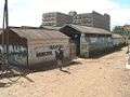 Municipal market
 Matatu stage (bus station)
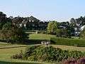 Mount Kenya Safari Club
See also
References
- ↑ http://www.pegasusarchive.org/arnhem/tatham_warter.htm
- ↑ "Weatherbase: Historical Weather for Nanyuki, Kenya". Weatherbase. 2011. Retrieved on November 24, 2011.
- ↑ "2009 Census Vol 1 Table 3 Rural and Urban Population | Open Data Portal". 2016-07-29. Archived from the original on 2016-07-29. Retrieved 2017-06-29.
- ↑ "Nanyuki Town Kenya - A Guide to Nanyuki Kenya". Softkenya.com. 2010-01-11. Retrieved 2017-06-29.
- ↑ Emerton, Lucy. "Mount Kenya: The Economics of Community Conservation" (PDF). International Institute for Environment and Development.
- ↑ "Mount Kenya Wildlife Conservancy - Magical Kenya". Magical Kenya. Retrieved 2017-06-29.
External links
| Wikimedia Commons has media related to Nanyuki. |
| Wikivoyage has a travel guide for Nanyuki. |