Kericho County
| Kericho County | |||
|---|---|---|---|
| County | |||
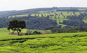 A tea plantation near Kericho in the Kenyan highlands. | |||
| |||
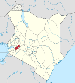 Location in Kenya | |||
| Coordinates: 0°22′00″S 35°18′00″E / 0.366667°S 35.3°ECoordinates: 0°22′00″S 35°18′00″E / 0.366667°S 35.3°E | |||
| Country |
| ||
| Formed | March 4th 2013 | ||
| Capital | Kericho | ||
| Government | |||
| • Governor | Paul Kiprono Chepkwony | ||
| Area | |||
| • Total | 2,454.5 km2 (947.7 sq mi) | ||
| Population (2009) | |||
| • Total | 752,396[1] | ||
| Time zone | UTC+3 (EAT) | ||
| Website |
kericho | ||
Kericho County is a county of Kenya. It has a population of 752,396 (2009 census) and an area of 2,111 km2.[2] Its capital and largest town is Kericho. The current governor is Professor Paul Kiprono Chepkwony also known as "Timbilwet".
Kericho County is home to the best of Kenyan tea which is renowned worldwide for its taste with its town square even known as Chai Square. Some of the largest tea companies including Unilever Kenya, James Finlay and Williamson Tea are based here. It is also home to the popular Ketepa brand.
The former Buret District is now part of Kericho County.
Subdivisions
| Authority | Type | Population* | Urban pop.* |
|---|---|---|---|
| Kericho | Municipality | 85,126 | 30,023 |
| Londiani | Town | 37,538 | 3,996 |
| Kipkelion | Town | 36,324 | 2,479 |
| Kipsigis | County | 309,505 | 2,186 |
| Total | - | 468,493 | 38,684 |
| * 1999 census. Source:[3] | |||
| Division | Population* | Urban pop.* | Headquarters | ||||
|---|---|---|---|---|---|---|---|
| Ainamoi | 119,696 | 26,133 | Kericho | ||||
| Belgut | 100,325 | 0 | - | Chilchila | 36,983 | 0 | |
| Kipkelion | 64,477 | 2,369 | Kipkelion | ||||
| Londiani | 59,441 | 4,328 | Londiani | ||||
| Sigowet | 61,778 | 2513 | |||||
| Soin | 25,793 | 0 | |||||
| Total | 468,493 | 34,343 | |||||
| * 1999 census. Sources:[4][5] | |||||||
Electoral constituencies
The county has six constituencies:
Services and Urbanisation
| County | Stats for the County (Percent) | ||||||||
|---|---|---|---|---|---|---|---|---|---|
| Urbanisation | 28.3 | ||||||||
| Literacy | 79 | ||||||||
| Attending School (15-18 Yrs) | 79.7 | ||||||||
| Paved Roads | 13.8 | ||||||||
| Good Roads | 58.5 | ||||||||
| Electricity Access | 11.8 | ||||||||
| Poverty Rate | 44.2 | ||||||||
|
Stats for the County | |||||||||
Source: USAid Kenya
References
- ↑ "Kenya Census 2009". scribd.com. Retrieved 15 May 2016.
- ↑ "Kenya Districts". statoids.com. Retrieved 15 May 2016.
- ↑ http://treasury.go.ke/cbs.go.ke/pdf/authority.pdf%5Bpermanent+dead+link%5D
- ↑ "Archived copy" (PDF). Archived from the original (PDF) on 28 September 2007. Retrieved 2007-03-23.
- ↑ "Archived copy". Archived from the original on 18 July 2011. Retrieved 2007-11-27.
This article is issued from
Wikipedia.
The text is licensed under Creative Commons - Attribution - Sharealike.
Additional terms may apply for the media files.