National Register of Historic Places listings in Indiana
This is a list of properties and districts in Indiana that are listed on the National Register of Historic Places. There are over 1,800 in total. Of these, 39 are National Historic Landmarks. Each of Indiana's 92 counties has at least one listing.
The locations of National Register properties and districts (at least for all showing latitude and longitude coordinates below), may be seen in an online map by clicking on "Map of all coordinates".[1]
-
- This National Park Service list is complete through NPS recent listings posted October 4, 2018.[2]
Current listings by county
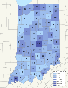
The following are approximate tallies of current listings by county. These counts are based on entries in the National Register Information Database as of March 13, 2009[3] and new weekly listings posted since then on the National Register of Historic Places web site.[4] There are frequent additions to the listings and occasional delistings and the counts here are approximate and not official. New entries are added to the official Register on a weekly basis.[5] Also, the counts in this table exclude boundary increase and decrease listings which modify the area covered by an existing property or district and which carry a separate National Register reference number.

| County | # of Sites | |
|---|---|---|
| 1 | Adams | 9 |
| 2 | Allen | 65 |
| 3 | Bartholomew | 22 |
| 4 | Benton | 5 |
| 5 | Blackford | 4 |
| 6 | Boone | 15 |
| 7 | Brown | 5 |
| 8 | Carroll | 23 |
| 9 | Cass | 15 |
| 10 | Clark | 17 |
| 11 | Clay | 14 |
| 12 | Clinton | 11 |
| 13 | Crawford | 2 |
| 14 | Daviess | 13 |
| 15 | Dearborn | 26 |
| 16 | Decatur | 10 |
| 17 | DeKalb | 29 |
| 18 | Delaware | 41 |
| 19 | Dubois | 13 |
| 20 | Elkhart | 36 |
| 21 | Fayette | 7 |
| 22 | Floyd | 20 |
| 23 | Fountain | 14 |
| 24 | Franklin | 14 |
| 25 | Fulton | 8 |
| 26 | Gibson | 9 |
| 27 | Grant | 18 |
| 28 | Greene | 7 |
| 29 | Hamilton | 31 |
| 30 | Hancock | 12 |
| 31 | Harrison | 6 |
| 32 | Hendricks | 21 |
| 33 | Henry | 13 |
| 34 | Howard | 13 |
| 35 | Huntington | 20 |
| 36 | Jackson | 17 |
| 37 | Jasper | 11 |
| 38 | Jay | 8 |
| 39 | Jefferson | 13 |
| 40 | Jennings | 7 |
| 41 | Johnson | 20 |
| 42 | Knox | 19 |
| 43 | Kosciusko | 16 |
| 44 | LaGrange | 7 |
| 45 | Lake | 75 |
| 46 | LaPorte | 30 |
| 47 | Lawrence | 13 |
| 48 | Madison | 18 |
| 49.1 | Marion: Center Township | 174 |
| 49.2 | Marion: Other | 68 |
| 49.3 | Marion: Duplicates | (1)[6] |
| 49.4 | Marion: Total | 241 |
| 50 | Marshall | 32 |
| 51 | Martin | 2 |
| 52 | Miami | 15 |
| 53 | Monroe | 44 |
| 54 | Montgomery | 21 |
| 55 | Morgan | 27 |
| 56 | Newton | 6 |
| 57 | Noble | 15 |
| 58 | Ohio | 3 |
| 59 | Orange | 15 |
| 60 | Owen | 15 |
| 61 | Parke | 44 |
| 62 | Perry | 8 |
| 63 | Pike | 3 |
| 64 | Porter | 36 |
| 65 | Posey | 18 |
| 66 | Pulaski | 7 |
| 67 | Putnam | 22 |
| 68 | Randolph | 13 |
| 69 | Ripley | 13 |
| 70 | Rush | 28 |
| 71 | St. Joseph | 94 |
| 72 | Scott | 3 |
| 73 | Shelby | 13 |
| 74 | Spencer | 7 |
| 75 | Starke | 2 |
| 76 | Steuben | 14 |
| 77 | Sullivan | 10 |
| 78 | Switzerland | 8 |
| 79 | Tippecanoe | 46 |
| 80 | Tipton | 2 |
| 81 | Union | 3 |
| 82 | Vanderburgh | 94 |
| 83 | Vermillion | 8 |
| 84 | Vigo | 48 |
| 85 | Wabash | 29 |
| 86 | Warren | 4 |
| 87 | Warrick | 8 |
| 88 | Washington | 8 |
| 89 | Wayne | 38 |
| 90 | Wells | 4 |
| 91 | White | 5 |
| 92 | Whitley | 6 |
| (Duplicates): | 14[7] | |
| Total: | 1,910 | |
See also
- Indiana Register of Historic Sites and Structures
- List of archaeological sites on the National Register of Historic Places in Indiana
- List of bridges on the National Register of Historic Places in Indiana
- List of Indiana covered bridges
- List of Indiana state historical markers
- List of National Historic Landmarks in Indiana
References
- ↑ The latitude and longitude information provided in this table was derived originally from the National Register Information System, which has been found to be fairly accurate for about 99% of listings. For about 1% of NRIS original coordinates, experience has shown that one or both coordinates are typos or otherwise extremely far off; some corrections may have been made. A more subtle problem causes many locations to be off by up to 150 yards, depending on location in the country: most NRIS coordinates were derived from tracing out latitude and longitudes from USGS topographical quadrant maps created under the North American Datum of 1927, which differs from the current, highly accurate WGS84 GPS system used by most on-line maps. Chicago is about right, but NRIS longitudes in Washington are higher by about 4.5 seconds, and are lower by about 2.0 seconds in Maine. Latitudes differ by about 1.0 second in Florida. Some locations in this table may have been corrected to current GPS standards.
- ↑ "National Register of Historic Places: Weekly List Actions". National Park Service, United States Department of the Interior. Retrieved on October 4, 2018.
- ↑ National Park Service (2009-03-13). "National Register Information System". National Register of Historic Places. National Park Service.
- ↑ "National Register of Historic Places: Weekly List Actions". National Park Service. Retrieved January 2, 2009.
- ↑ Weekly List Actions, National Register of Historic Places website
- ↑ The Indianapolis Park and Boulevard System is split between Center Township and three other townships in Marion County
- ↑ Angel Mounds, the Cavanaugh Bridge, the County Bridge No. 45, the County Line Bridge (Morristown, Indiana), the Ennis Archaeological Site (12 OW 229), the Huffman Mill Covered Bridge, the Laughery Creek Bridge, the Patoka Bridges Historic District, the Scotland Bridge, the Secrest Ferry Bridge, the Traders Point Eagle Creek Rural Historic District, and the Washington Street Historic District (Valparaiso, Indiana) span the borders between Vanderburgh and Warrick counties, Jackson and Washington counties, Daviess and Knox counties, Hancock and Rush counties, Monroe and Owen counties, Perry and Spencer counties, Dearborn and Ohio counties, Gibson and Pike counties, Boone and Clinton counties, Monroe and Owen counties, Boone and Marion counties, and Porter and Tippecanoe counties respectively. The Shakamak State Park Historic District is split between Clay, Greene, and Sullivan counties.
External links
| Wikimedia Commons has media related to National Register of Historic Places in Indiana. |
- Indiana Historic Sites and Structures Inventory
- Indiana State Historic Architectural and Archaeological Research Database
| Topics | |
|---|---|
| Lists by states |
|
| Lists by insular areas | |
| Lists by associated states | |
| Other areas | |
| |


