Lawton, Oklahoma metropolitan area
| Lawton metropolitan area | |
|---|---|
| Lawton metropolitan area | |
 | |
| Coordinates: 34°39′45″N 98°28′35″W / 34.6625°N 98.4764°W | |
| Country | United States |
| State(s) | Oklahoma |
| Largest city | Lawton, Oklahoma |
| Other cities |
- Cache - Elgin |
| Area | |
| • Total | 1,069.3 sq mi (2,769 km2) |
| Highest elevation | 2,476 ft (754 m) |
| Lowest elevation | 1,000 ft (304 m) |
| Population | |
| • Total | 130,291 (2,010 Census) |
| • Rank | 324th in the U.S. |
| • Density | 116.1/sq mi (44.8/km2) |
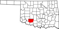
The Lawton Metropolitan Statistical Area, as defined by the United States Census Bureau, is an area consisting of two counties – Comanche and Cotton – in Oklahoma, anchored by the city of Lawton. As of the 2010 census, the MSA had a population of 124,089.[1][2]
Counties
Communities
Cities
Towns
See also
References
- ↑ "Table 1. Annual Estimates of the Population of Metropolitan and Micropolitan Statistical Areas: April 1, 2010 to July 1, 2012". 2012 Population Estimates. United States Census Bureau, Population Division. March 2013. Archived from the original (CSV) on April 1, 2013. Retrieved March 17, 2013.
- ↑ http://www2.census.gov/geo/maps/metroarea/stcbsa_pg/Feb2013/cbsa2013_OK.pdf

Coordinates: 34°39′45″N 98°28′35″W / 34.66250°N 98.47639°W
This article is issued from
Wikipedia.
The text is licensed under Creative Commons - Attribution - Sharealike.
Additional terms may apply for the media files.