Konjuh (mountain)
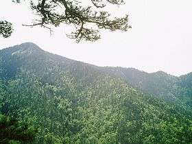
Konjuh is a mountain in north-east part of Bosnia and Herzegovina. Mountain is bordered by rivers of Seona, Turija, Litva, and Oskova on the north, river Gostelja and highway Tuzla–Sarajevo on north-east, and river Krivaja on south and west. With Ozren, Javor and Javornik, Konjuh makes part of mountain chain which with Trebavac and Majevica present transition of Dinaric mountain system to the spacious Panonian plain.[1]
Average height of this mountain is 1000 meters. Above this height there are tops: Šuplji Javor (1157 m), Vina Kruška (1088 m), Suho Drvlje (1206 m), Zidine (1180m), Brezina (1120 m), Vrh Konjuha (1328 m) and Bandijerka, top of Javorje (1261 m), Bijeli Vrh (1272 m) and Zečiji Rat (1275 m) on southwestern comb Smolin.[1]
Flora and fauna
Konjuh is covered with dense vegetation in conifer which prevails (pine and spruce), beech, maple and in a small number oak. On the mountain also grows very rare and curative lincura – srčanik (Gentiana lutea), which is on this mountain protected and endangered.[1]
In the woods of Konjuh there are wild animals like: brown bear, roe deer, wild boar, wolf, fox, squirrel, grouse, and in the streams and rivers trout and crayfish. Snakes that live here are horned viper, common viper, copperhead, and also lizard, green lizard and salamander.[1]
Cultural and historical monuments
On the mountain of Konjuh there are many necropolises stećaks, and only in the municipality of Kladanj 500 stećaks are known. There are also ruins of caravan road which is used for transport of salt from Tuzla, as well as monuments from World War II in Yugoslavia.[1]
Mountain protection
Hiking associations and nature lovers are trying for years to convince authorities that part of the mountain call a protected natural zone.[2] Government of Tuzla Canton submitted a Law for declaring parts of the mountain Konjuh a protected natural zone.[3]