Kings Highway Conservation District, Dallas
|
King's Highway Historic District | |
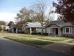 King's Highway in 2011 | |
 King's Highway Historic District  King's Highway Historic District | |
| Location | 900–1500 Blocks of King's Highway between W. Davis St. and Montclair Ave., Dallas, Texas |
|---|---|
| Coordinates | 32°45′7″N 96°50′32″W / 32.75194°N 96.84222°WCoordinates: 32°45′7″N 96°50′32″W / 32.75194°N 96.84222°W |
| Area | 30 acres (12 ha) |
| Architectural style | Bungalow/Craftsman, Four Square |
| MPS | Oak Cliff MPS |
| NRHP reference # | 94000606[1] |
| Added to NRHP | June 17, 1994 |
King's Highway is located in the Oak Cliff area of Dallas, Texas (USA). The district is bounded by Stewart Drive on the north, Davis Street on the south, Tyler Street on the east and Mary Cliff Road on the west. It is in Dallas Council District 3.[2]
The conservation district was established in 1988 by Dallas Ordinance 19910, and governs zoning, renovations and replacements, setbacks, etc. Replacement houses are required to meet standards making them similar to the surrounding houses and houses of the period, discouraging teardowns and preventing modern suburban-style architecture.
King's Highway was established as a conservation district in 1988 and was the first of its kind to be established in Dallas.
A quote from the conservation documents:
| “ | The homes in the Kings Highway Neighborhood were built primarily in the 1910s and 1920s. Craftsman, Prairie, Eclectic and Tudor styles common to this era are widely represented throughout. During this period, the apartments along the southeastern portion of Kings Highway provided temporary housing for those awaiting the construction of their homes in the adjoining neighborhood of Winnetka Heights. | ” |
| — City of Dallas Ordinace 19910, [3] | ||
See also
References
- ↑ National Park Service (2013-11-02). "National Register Information System". National Register of Historic Places. National Park Service.
- ↑ City of Dallas - Council District 3 Map (PDF). Retrieved 4 October 2006.
- ↑ Kings Highway Conservative District documentation: Dallas Ordinance 19910 (1988). Available online at Kings Highway Neighborhood Association
External links
| Wikimedia Commons has media related to King's Highway Historic District. |

