Karimganj district
Karimganj is one of the 33 districts of Assam, India. Karimganj city is both the administrative headquarters district and the biggest city of this district. It is located in Central Assam and borders Tripura and the Sylhet Division of Bangladesh. It was a part of the Sylhet district of Assam before the partition of India, and was given to India by Radcliffe Award vide Sylhet referendum while the rest of Sylhet district joined Pakistan. It became a district in 1983.
History
Early period
The early history of present district of Karimganj, Assam, is hazy and obscure. With available source materials and evidence, it is difficult to construct a chronologically comprehensive account of the early history of the region. Only a broad outline, with major gaps, can be attempted.
From the Kanpur copper inscriptions issued by King Banjarmasin, it is learned that the region has been within the Kampala Kingdom for about a hundred years since the 6th century. The Organisation of the region under the leadership of the pioneer immigrant Brahmans with p lough-based agriculture as economic basis had its beginning during this period. From the Kanpur copper plates issued by Samara Anathematize, it is learned that in the 7th century, this region, along with foothills of North Ca char Hills had passed on to the Atacama Kingdom of the Eastern Bengal. Of course, there is no direct evidence to prove it. In the 10th century, King Chandra of the renowned Chandra Dynasty of Eastern Bengal incorporated the entire region within his Manga Kingdom. During this period, the Chandragupta Mat haģ or monastery, situated at Chandrasekhar (8 miles From Karaganda town, now in Bangladesh), became a very reputed centro of learning. According to the renowned historian D.C. Sankara, the Chandragupta Martha was the greatest centro of Hindu-learning in the entire Eastern India of the early period. From two Bharat inscriptions of Govindakeshava Dena and Tanisha Devi, it is learnt that there was an independent Sriracha Rajah in the 12th century within which the entire Karaganda District along with a major portion of the Char plains were incorporated.
Middle Ages
When Shah Jalal, a Muslim Sufi Saint from Yemen, conquered Sylhet in 1328, Srihatta, along with a major portion of Karimganj district, passed to the Bengal Sultanate. A portion of Karimganj district comprising the present thana area of Patharkandi was under the control of the Tripura King at that period. However a large Persian force led by a man called Mirza Malik Muhammad Turani captured the town of Badarpur within this region in the late 14th century. Turani crowned himself king and married Umavati, the daughter of the defeated governor of the town, a Khasi Chief named Pura Raja. The family continued to expand their rule over the next few generations until their descendant, Malik Pratap Raja, eventually conquered the entirety of Patharkandi.
However, during the reign of Hussain Shah (1483–1519), this region - at that time known as Pratapgarh – also came under the Sultanate. There are two inscriptions - one of Hussain Shah, and another of his son Mahmud Shah, found respectively at Kaliganj and Suprakandi – to show that Bengal sultanate had complete sway over this entire region. The region, along with other parts of Sylhet, was incorporated within the Mughal Empire in 1576 during the reign of Akbar. According to Ain-I-Akbari, most of the areas of the district were placed under the Pratapgarh Revenue Mahal of the Silhat Sarkar of the Mughals. The district continued to be part of the Silhat Sarkar and Bangla Suba of the Mughals.
British Era and Freedom Movement
In 1785, the diwani of the Bangla Suba was taken over by the British East India Company and the District of Sylhet, of which Karimganj was a part, passed on to the British. However, up to 1786, the British could not establish their hegemony over the entire region. A local Zamindar, Radharam, brought under his administrative control, a vast region of Southern Karimganj, and local people started calling him Nawab Radharam. His blatant defiance of British authority brought the matters to a head, but Radharam survived two successive expeditions of the British contingents. Ultimately, a reinforced contingent succeeded in capturing him after defeating his forces. While he was being carried to Sylhet by the Company soldiers, Radharam reportedly committed suicide. It is only with his fall in 1786 that the British could establish their complete authority in the region around Karimganj.
In November 1857, three companies of the 34th Native Infantry stationed at Chittagong mutinied and they subsequently emerged in the south-east of the Sylhet District. At Latu village of present Karimganj district, these rebel soldiers encountered a contingent of the Sylhet Light Infantry under the command of Major Byng. The sepoys were defeated, but Major Byng was killed. At Malegar hillock of Latu village, the graves of the fallen rebels are still venerated by the local people.
In 1878, the British administration designated Karimganj town as the headquarters of the newly created sub-division of Karimganj. Before the Partition of India in 1947, Karimganj District was a sub-division of greater Sylhet District. Many tallukas and zamindari estates were located here. The estate of the erstwhile Zamindars of Hasanpur, in Badarpur is also situated in Karimganj.
Assam's Surma Valley (now partly in Bangladesh) had Muslim-majority population. On the eve of partition, hectic activities intensified by the Muslim League as well Congress with the former having an edge. A referendum had been proposed for Sylhet District (now in Bangladesh). Mazumdar along with Basanta Kumar Das (then Home Minister of Assam) travelled throughout the valley organising the Congress and addressing meetings educating the masses about the outcome of partition on the basis of religion. On 20 February 1947, Moulvi Mazumdar inaugurated a convention – Assam Nationalist Muslim's Convention at Silchar. There after another big meeting was held at Silchar on 8 June 1947.[1] Both the meetings, which were attended by a large section of Muslims paid dividend. He was also among the few who were instrumental in retaining the Barak Valley region of Assam, especially Karimganj with India.[2][3] Mazumdar was the leader of the delegation that pleaded before the Radcliffe Commission that ensured that a part of Sylhet (now in Bangladesh) remains with India despite being Muslim-majority (present Karimganj district).[4][11].
The entire eastern India was swept by violence just after India's partition and independence on 15 August 1947, scores of Hindus fled the newly created East Pakistan (now Bangladesh) for India, and Muslims fled Assam for East Pakistan. A large number of people lost their lives owing to violence, which resurfaced with more ferocity in 1950. Mazumdar, the only Muslim in the cabinet, along with his cabinet and party colleagues took up responsibility for the safety of both Hindus and Muslims in Karimganj, touring affected areas and arranging camps and rehabilitation for the refugees, organizing supplies and security.
During the Bangladesh’s war of liberation in 1970-71, he was in charge of relief-&-rehabilitation of the thousands of refugees who fled the then East Pakistan to Assam including Karimganj.
Partition & post-partition period
At the time of Partition of India in 1947, most of Sylhet District joined East Pakistan, which eventually became the independent nation of Bangladesh in 1971, barring three-and-half thana areas (Ratabari, Patharkandi, Badarpur and half of Karimganj thana) of the Karimganj sub-division. This truncated Karimganj sub-division was incorporated in the Cachar District of Assam as a full-fledged sub-division. The Karimganj sub-division was upgraded to a district on 1 July 1983.[5] Karimganj Town was designated as the district headquarters of the newly created Karimganj District.
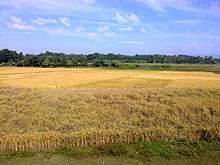
Geography
.jpeg)
Karimganj district occupies an area of 1,809 square kilometres (698 sq mi),[6] comparatively equivalent to Alaska's Afognak Island.[7] It is bounded on the south by Cachar District, and Hailakandi District, on the southwest by Tripura state, and on the west and northwest by Bangladesh. Karimganj Town, the administrative headquarters and main town of the district also bears the same name, that is, Karimganj. Karimganj town is located on the northern fringe of the district adjoining Bangladesh, by the river Kushiyara.
Its distance from Guwahati - the largest city of Assam - is approximately 330 km by road and about 350 km by rail. Distances of other important places are : Silchar - 55 km, Shillong - 220 km, Agartala - 250 km. Flanked on two sides by the rivers Kushiyara and Longai, Karimganj town is located just on the Bangladesh border with the river Kushiyara flowing in between. One prominent feature of the place is a long and winding canal called Noti Khal meandering through the town. Earlier, it used to be a connecting river way between Kushiyara and Longai facilitating river communication and also balancing of water-levels between the two rivers. Now, however, this canal has been blocked at several places through embankments and landfills to pave way for road transport and construction works. Latu is one of the historically interesting villages of Karimganj.
The forests of Karimganj were once rich in wildlife but now vanishing due to human onslaught. rare species found are Son Beel Tiger, Hoolock gibbon, Giant river otter, macaw parrots, Parakeets, Coypubara (2nd largest rodent in world), Phayre's leaf monkey, Pig-tailed macaque, Asian elephant, White-winged Wood Duck, etc., have been recorded.[8][9] The southern part was also recommended as 'Dhaleswari' wildlife sanctuary.[10][11]
Economy
Karimganj town is an important centre of trade and commerce in the North East India. Its river port, with elaborate infra-structures like cargo-terminal, jetty, warehouses etc., is capable of handling large volumes of cargoes carried by steamers plying through river ways via Bangladesh. Karimganj is also a borders trade centre and import-export business worth crores of rupees is carried out through the custom trade point at Dakbangla Ghat in the town and Sutarkandi Custom Station.
Divisions
Karimganj District has one sub-division. The district has 5 tehsils or development circles (Karimganj, Badarpur, Nilambazar, Patharkandi and Ramkrishna Nagar), two urban areas (Karimganj and Badarpur) 3 towns (Karimganj, Badarpur, and Badarpur Railway Town), 7 community development blocks (North Karimganj, South Karimganj, Badarpur, Patharkandi, Ramkrishna Nagar, Dullavcherra and Lowairpoa), 7 police stations (Karimganj, Badarpur, Ramkrishna Nagar, Patharkandi, Ratabari, Nilambazaar, and Bazarichara), 96 gram panchayats, and seven anchalik panchayats.
There are five Assam Legislative Assembly constituencies in this district: Ratabari, Patharkandi, Karimganj North, Karimganj South, and Badarpur.[12] Ratabari is designated for scheduled castes.[12] All five are in the Karimganj Lok Sabha constituency.[13]
Transport

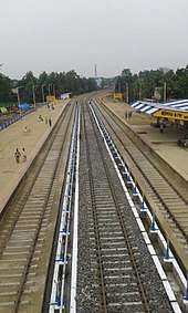
Karimganj town is linked via both rail and road transport with the rest of India. Karimganj town is a railway junction and broad gauge lines connecting Tripura with Assam pass through this station. Badarpur railway station is the biggest junction of the district. The most popular mode of passenger transport, however, is by road. A good number of buses - mostly night services - ply between Karimganj and Guwahati daily. Direct long distance bus services are also available to Shillong, Agartala, Aizawl and so on. Communication with Silchar, Badarpur, Patharkandi and other nearby places is also mainly dependent on road transport, with services by all sorts of light and heavy vehicles available at frequent intervals. The nearest airport is Kumbhirgram (85 km) near Silchar - the headquarters of the adjacent district of Cachar. Karimganj town is also an important river port and has seasonal cargo and freight transport links with Kolkata through river ways via Bangladesh.
Sutarkandi international border crossing
Sutarkandi international border crossing on Bangladesh–India border on Karimganj-Beanibazar route is in Karimganj district of Tripura in India.
Demographics
Population
According to the 2011 census Karimganj district has a population of 1,217,002,[14] roughly equal to the nation of Bahrain[15] or the US state of New Hampshire.[16] This gives it a ranking of 392nd in India (out of a total of 640).[14] The district has a population density of 673 inhabitants per square kilometre (1,740/sq mi) .[14] Its population growth rate over the decade 2001-2011 was 20.74%.[14] Karimganj has a sex ratio of 961 females for every 1000 males,[14] and a literacy rate of 79.72%.[14]
Religion
Muslims 527,214 form a slight majority in the district, at 52.3% of the population, with Hindus accounting for 47% according to the 2001 census.[17]
Language
Karimganj is one of several districts in Assam where Bengali is spoken by the majority of the population, as also in some other districts such as Cachar, Barpeta, Halaikandi, Dhubri and Goalpara. Bengali is the official language in Karimganj along with the other two districts of Barak valley such as Hailakandi and Cachar.[18] The Bengali dialect that is used in Karimganj is known as Sylheti. Meitei is spoken by the minority Bishnupriya and Meitei communities. There are also a small tribal communities like Hrangkhol, Kuki, Khasi, Tripuri and Sakachep.
Tourist Attractions
- Chhatachura Range: Originating from the south-eastern border of the district of Karimganj, Chhatachura vary forms the district’s border within the eastern side aspect with Hailakandi District. Chhatachura Peak at an altitude of 2087 feet is that the highest point. Saraspur is that the middle section and it’s at one thousand feet high.
- Badarpurghat: Badarpurghat is a historic fort built by the Mughals and later repaired by the British after damaging it during the Sepoy Rebellion of 1857, situated at Badarpur Ghat, the bank of the Rio Singhla, and is only 25 kilometres away from Karimganj town.
- Malegarh Crematorium of Sepoy Mutiny Soldiers: - Malegarh Crematorium is considered as a historic place. A sad but brave reminder of past where the soldiers who lost their lives during the 1857 Sepoy Mutiny were cremated. The year 1857 saw the rise of soldiers against British and during the revolt, more than 50 soldiers sacrificed their lives. They were cremated at the place named Malegarh in the district of Karimganj. It was a place of the district Sylhet of Bangladesh earlier before the independence of India.
- Son Beel: The place Son Beel is very famous as the 2nd largest wetland in the World as well as largest in Asia, after south american Pantanal and located in Karbi-anglong, Dima haso, hojai and Karimganj in central Assam, as well as Sylhet & Chittagong in Bangladesh. The presence of the hills at the east and west of Son Beel, creates a picturesque landscape. The size of this wetland draws a significant amount of tourists’ attraction. Rio Shingla River' passes through this Beel which Shingla bifurcates into two different rivers -Rio Kakra and Kochua. There is another wetland near Son beel named as Rata beel.
- Akbarpur: Indian government established an agriculture research center at Akbarpur to produce the grains of improved quality. The institute provides the training on the agriculture and acts as a helping hand for the farmers.
- Suterkandi: Suterkandi is famous for having an international trade centre. Moreover, there is an international border of India and Bangladesh too. India exports the materials like coal, fruits and Silicon to Bangladesh through this space.
References
- ↑ Bhattacharjee, J. B. (1977). Cachar under British Rule in North East India. Radiant Publishers, New Delhi.
- ↑ Barua, D. C. (1990). Moulvi Matlib Mazumdar- as I knew him. Abdul Matlib Mazumdar – birth centenary tributes, pp. 8–9.
- ↑ Purkayashta, M. (1990). Tyagi jananeta Abdul Matlib Mazumdar. The Prantiya Samachar (in Bengali). Silchar, India.
- ↑ Roy, S. K. (1990). Jananeta Abdul Matlib Mazumdar (in Bengali). Abdul Matlib Mazumdar – birth centenary tributes, pp. 24–27.
- ↑ Law, Gwillim (2011-09-25). "Districts of India". Statoids. Retrieved 2011-10-11.
- ↑ Srivastava, Dayawanti et al. (ed.) (2010). "States and Union Territories: Assam: Government". India 2010: A Reference Annual (54th ed.). New Delhi, India: Additional Director General, Publications Division, Ministry of Information and Broadcasting (India), Government of India. p. 1116. ISBN 978-81-230-1617-7.
- ↑ "Island Directory Tables: Islands by Land Area". United Nations Environment Program. 1998-02-18. Retrieved 2011-10-11.
Afognak 1,809km2
- ↑ Choudhury, A.U. (1999). Status and Conservation of the Asian elephant Elephas maximus in north-eastern India. Mammal Review 29(3): 141-173.
- ↑ Choudhury, A.U. (2004). Vanishing habitat threatens Phayre’s leaf monkey. The Rhino Found. NE India Newsletter 6:32-33.
- ↑ Choudhury, A.U. (1983). Plea for a new wildlife refuge in eastern India. Tigerpaper 10(4):12-15.
- ↑ Choudhury, A.U. (1983). Plea for a new wildlife sanctuary in Assam. WWF - India Newsletter 4(4):15.
- 1 2 "List of Assembly Constituencies showing their Revenue & Election District wise break - up" (PDF). Chief Electoral Officer, Assam website. Archived from the original (PDF) on 22 March 2012. Retrieved 26 September 2011.
- ↑ "List of Assembly Constituencies showing their Parliamentary Constituencies wise break - up" (PDF). Chief Electoral Officer, Assam website. Archived from the original (PDF) on 22 March 2012. Retrieved 26 September 2011.
- 1 2 3 4 5 6 "District Census 2011". Census2011.co.in. 2011. Retrieved 2011-09-30.
- ↑ US Directorate of Intelligence. "Country Comparison:Population". Retrieved 2011-10-01.
Bahrain 1,214,705 July 2011 est.
- ↑ "2010 Resident Population Data". U. S. Census Bureau. Archived from the original on 2011-11-18. Retrieved 2011-09-30.
New Hampshire 1,316,470
- ↑ ORGI. "Census of India Website : Office of the Registrar General & Census Commissioner, India". Archived from the original on 2007-05-14.
- ↑ Barak Valley
External links
| Wikimedia Commons has media related to Karimganj district. |
- Karimganj District official website
- KarimganjTown
- Karimganj District KARIMGANJ ONLINE
- About Karimganj
- Karimganj District
- Barak Valley
Places adjacent to Karimganj district | ||||||||||
|---|---|---|---|---|---|---|---|---|---|---|
| ||||||||||
| Topics | |||||||||||
|---|---|---|---|---|---|---|---|---|---|---|---|
| History | |||||||||||
| Administration | |||||||||||
| Districts and divisions |
| ||||||||||
| Geography | |||||||||||
| Culture | |||||||||||
| Arts, literature, music and cinema |
| ||||||||||
| People | |||||||||||
| Notable surnames |
| ||||||||||
| Urban areas | |||||||||||
| |||||||||||