Barak Valley
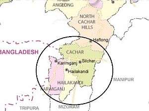
The Barak Valley[1] is a valley located in the southern region of the Indian state of Assam. The main city of the valley is Silchar. The region is named after the Barak river. The Barak valley mainly consists of three administrative districts of Assam State - namely Cachar, Karimganj, and Hailakandi. Among these three districts, Cachar and Hailakandi belonged to the Kachari Kingdom before the British Raj, whereas Karimganj belonged to the Sylhet district of then Assam province. Karimganj was separated from Sylhet after the 1947 referendum; with the rest of Sylhet falling under East Pakistan (now Bangladesh) and Karimganj under India.
Etymology
The name "Barak" has derived from the Dimasa words 'Bra' & 'Kro'. Bra means bifurcation and Kro upper portion/stream. The river Barak is bifurcated near Haritikar in the Karimganj district into Surma River and Kushiyara River. The upstream of this bifurcated river was called Brakro by the local Dimasa people. Over the years, Brakro got converted into Barak.[2]
Demography
Religion
Hinduism is the majority religion in the Barak Valley. According to the 2011, the religious composition of the valley population is as follows: Hindus 50.1% (1,812,141), Muslims 48.1% (1,744,958), Christians 1.6% (58,675), and others 0.2%. Hindus are the majority in Cachar district (59.83%), while Muslims are the majority in Hailakandi district (60.31%) and Karimganj district (56.26%).[3]
Bengali and English are the official languages of the district. Majority of the people primarily speak Sylheti, a dialect of Bengali. Other minority languages spoken in the district include Bhojpuri, Hindi, Meitei Manipuri
History
The region was originally part of the Tripura kingdom, which was annexed by Chilarai in the 16th-century to the Koch kingdom and administered by his half-brother Kamalnarayan. After the death of Nara Narayan, the kingdom, which came to be called the kingdom of Khaspur, became independent and was ruled by the descendants of Kamalnarayan. In the 17th-century, the last Koch ruler's daughter married the king of the Kachari kingdom, and the rule of Khaspur passed into the hands of the Kachari rulers, who eventually moved their capital from Maibang to Khaspur. The Kachari kingdom was annexed to British-India in 1832.
However, the dominance of Mughal Empire in Karimganj and Hailakandi finally ended with the introduction of British rule in Bengal. The undivided Cachar district (which also includes presently known as Hailakandi district) was included to Assam by British Rulers in 1832. The headquarters of the district was Silchar. The British Companies established a very large number of Tea Gardens (total 157) in the area and Silchar emerged as a very important center in this part of the country. All modern were introduced to the region in early twentieth century.
In 1947, when a plebiscite was held in Sylhet, the district was divided into two; the eastern part of Sylhet which is known as Karimganj remained with India whereas the other part fell under East Pakistan. Geographically the region is surrounded by hills from all three sides except its western plain boundary with Bangladesh. Nihar Ranjan Roy, author of Bangalir Itihash, says that "South Assam / Northeastern Bengal or Barak Valley is the extension of the Greater Surma/Meghna Valley of Bengal in every aspect from culture to geography".[4]
Assam's Surma Valley (now partly in Bangladesh) had Muslim-majority population. On the eve of partition, hectic activities intensified by the Muslim League as well Congress with the former having an edge. A referendum had been proposed for Sylhet District. Mazumdar along with Basanta Kumar Das (then Home Minister of Assam) travelled throughout the valley organising the Congress and addressing meetings educating the masses about the outcome of partition on the basis of religion.[5] On 20 February 1947 Moulvi Mazumdar inaugurated a convention – Assam Nationalist Muslim's Convention at Silchar. Thereafter another big meeting was held at Silchar on 8 June 1947.[6] Both the meetings, which were attended by a large section of Muslims paid dividend. He was also among the few who were instrumental in retaining the Barak Valley region of Assam, especially Karimganj with India.[7][8] Mazumdar was the leader of the delegation that pleaded before the Radcliffe Commission that ensured that a part of Sylhet (now in Bangladesh) remains with India despite being Muslim-majority (present Karimganj district).[9][10] Arun Kumar Chanda did not join Bordoloi cabinet in 1946 but preferred to do social work as a legislator and also to uplift the premier educational institution, G.C. College. Unfortunately he soon died, leaving a huge vacuum of an able Bengali Hindu leader with a secular bent of mind.
Wild life
The Asian elephant has already vanished from most of the valley.[11][12] The southern part was also recommended as 'Dhaleswari' wildlife sanctuary.[13] Barail is the only wildlife sanctuary of the Barak valley region. It was initiated by noted naturalist Dr Anwaruddin Choudhury, who originally hailed from this region in early 1980s.[14] This sanctuary was ultimately notified in 2004. Hailakandi have Inner line reserve forest and Katakhal reserve forest.[15]
Constituencies
Barak Valley has two Lok Sabha seats.
Notable people
- Abdul Matlib Mazumdar
- Arun Kumar Chanda
- Moinul Hoque Choudhury
- Karnendu Bhattacharjee, EX- MP of Rajya Sabha, Indian National Congress
- Debojit Saha (Singer & Television host)
- Kabindra Purkayastha (ex-Member of Lok Sabha), Bharatiya Janata Party
- Santosh Mohan Dev (Former Member of Lok Sabha), Indian National Congress, ex Minister of Heavy Industry and Public Enterprises in the Union Cabinet
- Dilip Kumar Paul(Deputy Speaker of the Assam Legislative Assembly), Bharatiya Janata Party
- Prof. B. B. Bhattacharya (Ex Vice Chancellor, Jawaharlal Nehru University, New Delhi)
- Sushmita Dev
Notes
- ↑ (Tunga 1995, p. 1)
- ↑ Barman Saroj Kr.(1995):Reminiscence Of The Past.Silchar:Kasturi Barman
- ↑ Indian Census Archived 14 May 2007 at the Wayback Machine.
- ↑ Ray, Niharranjan (1980-01-01). Bangalir itihas (in Bengali). Paschimbanga Samiti.
- ↑ Chowdhury, Dewan Nurul Anwar Husain. "Sylhet Referendum, 1947". en.banglapedia.org. Banglapedia. Retrieved 20 November 2016.
- ↑ Bhattacharjee, J. B. (1977). Cachar under British Rule in North East India. Radiant Publishers, New Delhi.
- ↑ Barua, D. C. (1990). Moulvi Matlib Mazumdar- as I knew him. Abdul Matlib Mazumdar – birth centenary tributes, pp. 8–9.
- ↑ Purkayashta, M. (1990). Tyagi jananeta Abdul Matlib Mazumdar. The Prantiya Samachar (in Bengali). Silchar, India.
- ↑ Roy, S. K. (1990). Jananeta Abdul Matlib Mazumdar (in Bengali). Abdul Matlib Mazumdar – birth centenary tributes, pp. 24–27.
- ↑ "Assam Election Results - What does it mean for Bangladesh?". thedailystar.net. The Daily Star. 21 May 2016. Retrieved 20 November 2016.
- ↑ Choudhury, A.U. (1999). Status and Conservation of the Asian elephant Elephas maximus in north-eastern India. Mammal Review 29(3): 141-173.
- ↑ Choudhury, A.U. (2004). Vanishing habitat threatens Phayre’s leaf monkey. The Rhino Found. NE India Newsletter 6:32-33.
- ↑ Choudhury, A.U. (1983). Plea for a new wildlife refuge in eastern India. Tigerpaper 10(4):12-15.
- ↑ Choudhury, A.U. (1989). Campaign for wildlife protection:national park in the Barails. WWF-Quarterly No. 69,10(2): 4-5.
- ↑ Choudhury, A.U. (2005). Amchang, Barail and Dihing-Patkai – Assam’s new wildlife sanctuaries. Oryx 39(2): 124-125.
References
- Tunga, S. S. (1995). Bengali and Other Related Dialects of South Assam. Delhi: Mittal Publications. Retrieved February 19, 2013.
External links
Coordinates: 24°48′N 92°45′E / 24.800°N 92.750°E
| Topics | |||||||||||
|---|---|---|---|---|---|---|---|---|---|---|---|
| History | |||||||||||
| Administration | |||||||||||
| Districts and divisions |
| ||||||||||
| Geography | |||||||||||
| Culture | |||||||||||
| Arts, literature, music and cinema |
| ||||||||||
| People | |||||||||||
| Notable surnames |
| ||||||||||
| Urban areas | |||||||||||
| |||||||||||