Dhubri
| Dhubri | |
|---|---|
| City | |
 Historic Netai Dhubuni Ghat | |
 Dhubri Location in Assam | |
| Coordinates: 26°01′N 90°00′E / 26.02°N 90°ECoordinates: 26°01′N 90°00′E / 26.02°N 90°E | |
| Country | India |
| State | Assam |
| District | Dhubri |
| Government | |
| • Body | Dhubri Municipality |
| • No.of wards | 16 |
| Area | |
| • Total | 18 km2 (7 sq mi) |
| • Water | 1.4 km2 (0.5 sq mi) |
| Area rank | 8th Assam |
| • Rank | 8th Assam |
| Languages | |
| • Official | Assamese |
| Time zone | UTC+5:30 (IST) |
| PIN | 783301 |
| ISO 3166 code | IN-AS |
| Vehicle registration | AS-17 |
| Website |
dhubri |
Dhubri (Pron: ˈdʊbri) is the headquarter of Dhubri district (Assam) India. It is an old town on the bank of the Brahmaputra and Gadadhar rivers, with historical significance. In 1883, the town was first constituted as a Municipal Board under British regime. It is situated about 277.4 kilometres (172 mi) west from Dispur, the state capital of Assam.
Dhubri was an important commercial centre and had a busy river port particularly for jute. Dhubri is called the "Land of Rivers" as it is covered three sides by rivers.[1]
History

The word Dhuburi comes from a legendary lady named Netai-Dhubuni. The story is connected with Behula-Lakhindar. The word Dhubuni is considered a corruption of 'Dhuburi'. According to Bodo-Kacharis, the word is of Bodo origin and derived from Dubra, a kind of grass. The story of lady Netai-Dhubuni is widely accepted for the naming history of Dhubri and that is where the Gurdwara Sri Tegh Bahadur Sahib stands.
This place is famous for the Sikh Gurdwara Gurdwara Damdama Sahib or Thara Sahib which was constructed in memory of visit of First Sikh Guru Nanak Dev and later it was followed by visit of Ninth guru, Guru Tegh Bahadur and the Gurdwara is named as Gurdwara Sri Guru Tegh Bahadur Sahib. Hence, it has great importance for Sikh community.
Until 1874, Dhubri was mostly a part of Bengal kings. In 1874, the British Government created a new province named Assam Valley Province and incorporated Goalpara district area comprising three civil subdivisions Dhubri, Goalpara and Kokrajhar with the new Assam Province. In 1879, the district headquarters was shifted from Goalpara to Dhubri town. The district of Dhubri is again subdivided in three districts namely Dhubri, Goalpara and Kokrajhar. The town of Dhubri falls under the jurisdiction of the district of Dhubri whose headquarters is at town Dhubri.
The present Dhubri District is one of the three Civil Sub-divisions of erst-while Goalpara district, established in 1876 during British regime. In 1879 the District headquarters was shifted from Goalpara to Dhubri.
In the year 1983 Goalpara district was divided into four separate districts and Dhubri is one of those. Covering an area of 2,838 km2. including forests, riverines, hills etc. the district has become the most densely populated district in India with a density of 584 persons per km2.(As per 2001 census).
Dhubri District has been visited by many historical personalities like Guru Nanaka, Srimanta Sankardeva, Guru Teg Bahadur, Swami Vivekananda, Mahatma Gandhi, Netaji Subhas Chandra Bose, Gopinath Bordoloi and others.
Dhubri town also was very famous for the Match Factory (WIMCO), though it has shut down due to circumstances but still people who had witnessed the same still remembering the beauty of the factory its staff quarters and their modern art of living.
Dhubri is also famous for its Durga Puja and Dashera.
The Dhubri Town was first constituted as a Municipality in 1883. The Dhubri Town is 290 km far from the State Capital at Dispur.
Demographics
As of 2011 India census,[2] Dhubri had a population 63,388. Males constitute 51% of the population and females 49%. Dhubri has an average literacy rate of 74%, higher than the national average of 59.5%: male literacy is 79% and, female literacy is 68%. In Dhubri, 11% of the population is under 6 years of age. With close to 75% of its population Muslims, it is one of the minority concentrated districts of India.
Most of these people are Desi (Goalpariya Assamese people which includes the Hindu and Muslim Goalpariya people) people. In Dhubri town, Bengali constitute about 50% of the population. This was the region of the Koch kingdom.
Geography and climate
Dhubri lies at 89.5 degree east longitude and 26.1 degree north latitude, and about 34 metres or 110 feet above sea level. Dhubri is covered by rivers on three sides, predominated by the mighty Brahmaputra River, which is a sorrow as well as joy for the dwellers.
As is typical for Assam and Tripura, Dhubri has a monsoon-influenced humid subtropical climate (Köppen Cwa), being a little too cool to qualify as a tropical monsoon climate. The "cool" or winter season from November to February is warm to very warm during the afternoon, and pleasantly cool in the morning. The "hot" season of March and April is indeed hot and sees increasing humidity and rain, leading into the oppressively humid and extremely wet monsoon season from May to the middle of October.
| Climate data for Dhubri (1971–2000) | |||||||||||||
|---|---|---|---|---|---|---|---|---|---|---|---|---|---|
| Month | Jan | Feb | Mar | Apr | May | Jun | Jul | Aug | Sep | Oct | Nov | Dec | Year |
| Record high °C (°F) | 29.9 (85.8) |
33.2 (91.8) |
38.3 (100.9) |
41.1 (106) |
41.4 (106.5) |
39.1 (102.4) |
37.8 (100) |
37.0 (98.6) |
38.8 (101.8) |
34.3 (93.7) |
32.1 (89.8) |
27.8 (82) |
41.4 (106.5) |
| Average high °C (°F) | 23.7 (74.7) |
26.2 (79.2) |
31.1 (88) |
31.6 (88.9) |
30.7 (87.3) |
31.5 (88.7) |
31.0 (87.8) |
32.0 (89.6) |
30.9 (87.6) |
30.1 (86.2) |
27.7 (81.9) |
24.5 (76.1) |
29.3 (84.7) |
| Average low °C (°F) | 8.6 (47.5) |
10.5 (50.9) |
15.2 (59.4) |
20.2 (68.4) |
22.2 (72) |
24.4 (75.9) |
25.1 (77.2) |
25.2 (77.4) |
24.2 (75.6) |
21.1 (70) |
15.5 (59.9) |
10.6 (51.1) |
18.5 (65.3) |
| Record low °C (°F) | 2.4 (36.3) |
2.8 (37) |
7.4 (45.3) |
6.4 (43.5) |
15.9 (60.6) |
13.9 (57) |
20.8 (69.4) |
21.7 (71.1) |
19.4 (66.9) |
17.2 (63) |
9.4 (48.9) |
7.8 (46) |
2.4 (36.3) |
| Average precipitation mm (inches) | 6.9 (0.272) |
18.1 (0.713) |
42.6 (1.677) |
177.7 (6.996) |
410.9 (16.177) |
607.4 (23.913) |
652.8 (25.701) |
467.0 (18.386) |
443.0 (17.441) |
167.8 (6.606) |
14.3 (0.563) |
8.0 (0.315) |
3,016.6 (118.764) |
| Average rainy days | 0.6 | 1.5 | 2.8 | 9.3 | 15.7 | 16.6 | 19.1 | 13.1 | 13.5 | 5.6 | 1.0 | 0.6 | 99.3 |
| Source: India Meteorological Department (record high and low up to 2010)[3][4] | |||||||||||||
Educational institutes
College

- Bholanath College or B. N. College (Established in 1946) is the oldest and premier college in western Assam.
- Dhubri Law College
- Dhubri Girls' College
- Dhubri B. Ed College
- Dhubri Medical College
- Ajmal College of Arts & Science
- Greenfield Junior College Dhubri
- Royal Public Junior College
- Dhubri College of Arts & Science
- Elite Academy, Hatsingimari
- Hamidabad College
School
- Bidyapara Boys Higher Secondary School, Dhubri
- Government Boys Higher Secondary School
- Sishu Pathsala Higher Secondary School
- Government Girls Higher Secondary School
- Vivekananda Vidyapith
- Dhubri Municipal High School
- Jawahar Hindi High School
- Sankardev Shishu Bidya Niketan, Dhubri
- Bidyapara Girls High School
- S.P. English Medium High School
- Happy Convent School
- St. Agastya School
- Bethel Baptist Mission School
- Paradise Convent School
- Elite Academy, Hatsingimari
- 128 no. Bidyapara LP School
- Jamadarhat Janata Higher Secondary School
- Rasaraj Jatiya Vidlaya
- Dhubri Jatiya Vidlaya
- Brahmaputra Jatiya Vidyalaya
Culture & festivals
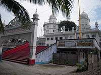
More than 50,000 Hindus, Sikhs, and Muslims assemble in this historic shrine every year in the month of December to mark the martyrdom of Guru Tegh Bahadur, which starts on 3 December with great solemnity and ceremony. Sikhs call the week long reverence of Sahidee-Guru-Parav which is marked with a massive procession. Guru Tegh Bahadur thus earned the affectionate title of "Hind-di-Chadar" or the Shield of Hind dates back to Hindustan.
Transportation
Airport
Dhubri has an airport at Rupshi which is about 23 km from the town. It was constructed during World War II by the British mainly for military purpose to accommodate 52 jet airplanes. Until 1983, the Indian Airlines and some private commercial flights operated regularly between Calcutta, Guwahati and Dhubri. Now it is totally closed. However, recently the ministry of DONER, GOI, has taken some initiative to renovate and restore the airport. An airport authority team from Guwahati conducted a survey the historic airport, whether the place could be rebuilt as an airport.
Sengajan multimodal waterways terminal
Dhubri multimodal waterways terminal on Brahmaputra in Dhubri is being developed as part of Bharatmala and Sagarmala projects.[5] The town had a very busy river port on the bank of the Brahmaputra which was used as an international trade centre with the neighbouring countries, specially during the British Raj.
Railway
The importance of the railway station and the MG line was also decreased since 1947, when the direct line to Calcutta was snapped as it ran through erstwhile East Pakistan (now Bangladesh). The train service has newly started on 2010 again, and it is functioning smoothly. However the train services running from the Dhubri railway station are taking a new route from Dhubri to Kamakhya and Guwahati Junction. Trains originating from Dhubri station are, Dhubri – Silghat (Rajya Rani Express), Dhubri – Siliguri (Inter City Express) Dhubri Fakiragram passenger and New Bongaigaon Siliguri Jn Demu Special Via Dhubri
Tourism
Dhubri District is bestowed with attractive scenic beauties. Both the banks of river Brahmaputra with its lush green fields, blue hills and hillock is a feast to the eyes of the onlookers. The Gurdwara Tegh Bahadur Shaibji, the Rangamati Mosque, Mahamaya Dham, Chakrasila wildlife sanctuary and the royal palaces attract the people for their unique structures, religious sanctity and mythological importance.
Places of interest
- Mahamaya Dham and shakti pith Snan Ghat:- of Bogribari, about 30–35 km east from Dhubri town is next to Kamakhya (Guwahati) and Madan-Mohan (Cooch Behar) in its attraction to the pilgrims and tourists. Originally the famous mother Goddess Mahamaya of Parvatjowar was worshipped by the local people like Kacharies, Koches and Naths. It was the presiding deity of the Jaminder of Parvatjowar. Nowadays the mother Mahamaya is worshipped by all Hindus.
- Gurdwara Sri Guru Tegbahadur Sahibji: In the heart of the Dhubri Town and on the bank of the river mighty Brahmaputra, this famous Gurdwara is situated. Sikh Guru Nanak visited this place in 1505 AD and met Sri Sankardeva during Guru Nanak Devji's way from Dhaka to Assam. Thereafter the Ninth Sikh Guru Teg Bahadur came to this place in the year 1666 and established the Gurdwara during 17th century accompany of Raja Ram Singh. Sikh devotees from all over India and abroad assembled in this Gurdwara every year in the month of December to mark the Martydom of Sri Guru Teg Bahadur with due solemnity and ceremony. Sikh devotees called reverence of Sahidee-Guru-Parav.
- Panchpeer Dargaha: It is Mazar Sharif of five Sufi Saints who accompanied Raja Ram Singh during his time of Mughal fight with the Ahom Regime of Assam. Guru Tegh Bahadur had also accompanied along with the Sufi Saints.
- Rangamati Mosque: Rangamati Mosque or Panbari Mosque was built during 17th century by Hussain Shah, the Governor of Bengal belongs to pre-Mughal period which can be recognised from its typical architectural design. It is about 25 km from township of Dhubri. Rangamati area was once a very prosperous during the reign of the Koch rulers as a frontier post. During Mughal regime Rangamati was a great fort of the invading Mughal Army. This unique Mosque was used as a prayer place by the Mohmmedan Soldiers. There is also an Idgah and a deep well which were also constructed during the same period.
- Other significant features: Two world famous wetlands – Dheer Beel and Diplai Beel adjoin Chakrasila wildlife Sanctuary. These two Beels are home to a large number of fishes, turtles, prawn and birds both indigenous and migratory.
- Chakrasila Wildlife Sanctuary: In 1994 Chakrasila Hill Reserve Forest was declared as Chakrasila Hill Wildlife Sanctuary by the government of India covering 4558.7 hectares of land. The distribution of varieties of plant species in Chakrasila provides diverse niches for many species of wildlife. The significant golden langur exists in Chakrasila Wildlife Sanctuary in addition to other mammals like leopard, leopard cat, porcupine, pangoline, flying squirrel and civet cat. adjutant stork, Indian owl, myna, parakeet, dove, hornbil, jungle fowl, kingfisher, heron, darter, snipe and teal are the birds commonly found. Python, monitor, crait, cobra, turtle, tead and frog are some reptiles and amphibia that are also found. It is about 70 km from Dhubri Town. This sanctuary provides facilities / activities such as bird watching, forest trekking, wildlife and nature photography. Local guides are available on payment. There is a site for erecting tents and free accommodation for a group of 15 individuals with hygienic drinking water in the camp Tapoban provided by the local NGOs.
- Florican Garden: A newly setup garden-cum-natural park located at Bilasipara about 50 km from Dhubri Town.
- Others: Other tourist places include Matiabag Palace at Gauripur, Netai Dhubuni Ghat at Dhubri Town, Chandardinga Hillock, Dudhnath Mondir at Salkocha, Ramraikuti at Satrasal, Airport of IInd World War and Soreswar beel at Rupshi, Dhubri matches factory.
Flora and fauna
On 14 July 1994, a virgin forest patch of Dhubri District of Assam was declared as a wildlife sanctuary by the gazette notification of the Assam Government. This sanctuary has been named as "Chakrashila Wildlife Sanctuary". This is the youngest sanctuary of the North East India having an area of 11,260.00 acres (45.5676 km2). Chakrasila is unique because of the presence of golden langur (Presbytis geei) which is found nowhere else except along the Assam and Bhutan border. Besides, the virgin forest of Chakrasila Wildlife Sanctuary is endowed with rare specimens of trees, shrubs, medicinal plants, mammals, reptiles and exquisite birds and insects.
Geographical location of the Chakrasila Wildlife Sanctuary is in the latitude 26° 15' to 26° 26' N and longitude 90° 15' to 90 ° 20' E. It is in the District of Dhubri, the western most region of Assam. It is 68 km from the District headquarters Dhubri and 219 km from the Borjhar Airport of Guwahati City.
There are several small springs for quenching the thirst of the wild animals of this hilly forest. But the two major perennial springs in the sanctuary are howhowi Jhora and Bamuni Jhora, which flow over the rocks, sparkling and spattering throughout the year, adding to the scenic beauty of the sanctuary.
Climatic conditions of Chakrasila Wildlife Sanctuary is like that of temperate zone with dry winter and hot summer followed by heavy rains. Annual rainfall is between 200 to 400 cm. Soil is azonal, forestlike and hilly. temperature throughout the year generally varies between 8 °C to 30 °C.
The diverse eco-systems of Chakrasila present a model habitat diversity and support various mammalian species like tiger, leopard, golden langur, leopard cat, gaur, mongoose, porcupine, pangoline, flying squirrel, civet cat, etc. Along with all these prolific gifts of the nature Chakrasila has a wide variety of avifauna.
It is to be noted that the two internationally recognized wetlands namely Dhir and Deeplai has not been yet taken inside the declared boundary of the sanctuary. But they are very a part of the Chakrasila eco-system. It is expected that in due course they will be included within the sanctuary. Courtesy : Nature's Beckon ( An Environmental Activist of North-East )
Politics
Dhubri is part of Dhubri (Lok Sabha constituency).[7]
Media
Dhubri has an All India Radio Relay station known as Akashvani Dhubri. It broadcasts on FM frequencies.
Notable people
- Pramathesh Barua, Bollywood filmmaker
- Jamuna Barua, Bollywood actress
- Padma Shri Pratima Barua Pandey, singer
- B. C. Sanyal, painter, sculptor, Art teacher
- Sarat Chandra Sinha, fifth Chief Minister of Assam, social activist.
- Rebati Mohan Dutta Choudhury, noted Bengali, Assamese litterateur.
- Vijay Saxena, Bollywood actor
- Tapas Sen, Theatre Artist
- Priyadarshini Chatterjee, Femina Miss India World in 2016
- Saifuddin Ahmed, Former Actor
- Javed Zaman, Indian first-class cricketer from Assam
See also
References
- ↑ "Priceless heritage gets funds to survive". The Telegraph. Calcutta. 13 October 2007. Retrieved 10 June 2018.
- ↑ "Census of India 2001: Data from the 2001 Census, including cities, villages and towns (Provisional)". Census Commission of India. Archived from the original on 2004-06-16. Retrieved 2008-11-01.
- ↑ "Dhubri Climatological Table Period: 1971–2000". India Meteorological Department. Retrieved 27 April 2015.
- ↑ "Ever recorded Maximum and minimum temperatures up to 2010" (PDF). India Meteorological Department. Archived from the original (PDF) on 21 May 2013. Retrieved 27 April 2015.
- ↑ Bharatmala presentation
- ↑ "Pin Code of Dhubri". citypincode.in. Retrieved 2014-05-13.
- ↑ "List of Parliamentary & Assembly Constituencies" (PDF). Assam. Election Commission of India. Archived from the original (PDF) on 2006-05-04. Retrieved 2008-10-05.
External links
| Wikimedia Commons has media related to Dhubri. |
| Topics | |||||||||||
|---|---|---|---|---|---|---|---|---|---|---|---|
| History | |||||||||||
| Administration | |||||||||||
| Districts and divisions |
| ||||||||||
| Geography | |||||||||||
| Culture | |||||||||||
| Arts, literature, music and cinema |
| ||||||||||
| People | |||||||||||
| Notable surnames |
| ||||||||||
| Urban areas | |||||||||||
| |||||||||||