Silchar Airport
| Silchar Airport | |||||||||||
|---|---|---|---|---|---|---|---|---|---|---|---|
 | |||||||||||
| Summary | |||||||||||
| Airport type | Public, military | ||||||||||
| Owner | Indian Air Force | ||||||||||
| Operator | Indian Air Force, Airports Authority of India | ||||||||||
| Serves | Silchar, Hailakandi, Karimganj | ||||||||||
| Location | Kumbhirgram, Silchar, Assam, India | ||||||||||
| Elevation AMSL | 352 ft / 107 m | ||||||||||
| Coordinates | 24°54′47″N 092°58′43″E / 24.91306°N 92.97861°E | ||||||||||
| Map | |||||||||||
 IXS Location of airport in Assam | |||||||||||
| Runways | |||||||||||
| |||||||||||
| Statistics (April 2017 - March 2018) | |||||||||||
| |||||||||||
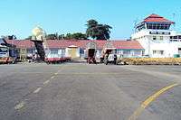
Silchar Airport (IATA: IXS, ICAO: VEKU) is located at Kumbhirgram, 29 km. from Silchar in the state of Assam, India built by the British as RAF Station Kumbhirgram in 1944 and transferred to the Royal Indian Air Force (RIAF). It is also a Civil enclave airport as it is under the control of Indian Air Force. The airport is situated on the foothills of the Barail range. It is the third busiest airport of the north-east India next to Guwahati and Imphal. In 2014-15, Silchar Airport handled 290,000 passengers.[4]
Facilities

Silchar airport is situated at an elevation of 338 feet above the sea level. It covers the land area of 36.70 Acres. There is only one domestic terminal. The terminal has four check-in counters along with one boarding gate allows a facility to handle nearly 300 passengers at a given time with 150 each at the arrival and the departure section. Rest rooms are also available for transit passengers with charges applied as per AAI rules. There are two conveyor belts available in the arrival building to support multiple aircraft at a single time. Indian Oil handles the Aviation fuel service department of Silchar Airport. Silchar airport has a variety of options for eating and shopping at the airport premises. Moreover, shops selling local handicraft items are also there at the airport. The airport comes under the administrative control of the Airports Authority of India. The guidelines prescribed by the Airports Authority of India are adhered to while carrying out the daily operations of Silchar Airport. Lighting System: PAPI - Precision approach path indicator visual aid for both side of the runway (06/24) that enables pilots to maintain the correct approach (in the vertical plane) towards the airport and ILS - Instrument landing system provides a direction for approaching when the aircraft tune its receiver to the ILS frequency, it provides both lateral and a vertical signals. Glide slope station which is an antenna array sited to one side of the runway touchdown zone is also available towards runway 06.[5]
Airlines and destinations
| Airlines | Destinations |
|---|---|
| Air India | Imphal, Kolkata |
| Jet Airways | Guwahati, New Delhi |
| SpiceJet | Guwahati, Kolkata, New Delhi |
| Indigo | Guwahati, Kolkata (To start soon) |
References
- ↑ "Traffic News for the month of March 2018: Annexure-III" (PDF). Airports Authority of India. 1 May 2018. p. 3. Retrieved 1 May 2018.
- ↑ "Traffic News for the month of March 2018: Annexure-II" (PDF). Airports Authority of India. 1 May 2018. p. 3. Retrieved 1 May 2018.
- ↑ "Traffic News for the month of March 2018: Annexure-IV" (PDF). Airports Authority of India. 1 May 2018. p. 3. Retrieved 1 May 2018.
- ↑ "DATA PROFILE OF AAI AIRPORTS & CIVIL ENCLAVES". Airports Authority of India. Airports Authority of India. Retrieved 5 November 2016.
- ↑ "Technical Information - Silchar Airport". Airports Authority of India. Airports Authority of India. Retrieved 5 November 2016.
External links
| Wikimedia Commons has media related to Silchar Airport. |
- Airport information for VEKU at World Aero Data. Data current as of October 2006.