Grand Mesa Scenic and Historic Byway
| |
|---|---|
| Route information | |
| Length | 50.4 mi[1] (81.1 km) |
| Major junctions | |
| South end |
|
|
| |
| North end |
|
| Location | |
| Counties | Delta, Mesa |
| Highway system | |
|
Colorado State Highways
| |

Grand Mesa Scenic and Historic Byway, also known at the Grand Mesa National Scenic and Historic Byway, is a scenic byway in Colorado.
Route description
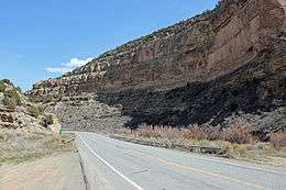
The byway runs north from Cedaredge along Highway 65, to the top of the Grand Mesa at more than 10,000 feet (3,000 m). It also includes Land's End Road to the Land's End Observatory from Highway 65. The byway continues past Island Lake, one of more than 300 trout-filled lakes in Grand Mesa National Forest. On the north side of the Mesa are the towns of Mesa, Collbran, and Powderhorn Ski Resort.[2][3] The byway continues along De Beque Canyon, with its colorful sandstone bluffs, and eventually meets Interstate 70 in the town of De Beque.

Historic and scenic byway designations:
- National Scenic Byway received in 1996.
- Colorado Scenic and Historic Byway by the Colorado Department of Transportation received in 1991.
- Forest Service Byway received in 1992.[2]
Scenic Overlooks include:
- Cedaredge overlook - an easy access overlook
- Land O Lakes overlook - a 1/4 mile moderate walk by foot
- Island Lake - an easy access overlook with restrooms and accessible boat ramp
- Grand Mesa Visitor Center - easy to moderate access with restrooms
- Mesa Lakes Lodge area - an easy to moderate access with restrooms
- Jumbo Lakes area - an easy access overlook with restrooms
- Skyway Point - an easy access
- Powderhorn - an easy access overlook with restrooms
- I-70 pullout and interpretation information[3]


Major intersections
| County | Location | mi | km | Destinations | Notes |
|---|---|---|---|---|---|
| Delta | Cedaredge | 0.0 | 0.0 | ||
| Mesa | | 40.2 | 64.7 | ||
| | 50.4 | 81.1 | |||
| 1.000 mi = 1.609 km; 1.000 km = 0.621 mi | |||||
- Near mile marker 58, or about 3.5 miles from Interstate-70.
See also
References
- ↑ Microsoft; Nokia (January 1, 2015). "Driving directions along route" (Map). Bing Maps. Microsoft. Retrieved January 1, 2015.
- 1 2 Grand Mesa Scenic Byway Grand Mesa Scenic and Historic Byway Association. 2010-2011.
- 1 2 Grand Mesa Scenic Byway Map Grand Mesa Scenic and Historic Byway Association. 2010-2011.
External links
| Wikimedia Commons has media related to Grand Mesa Scenic and Historic Byway. |
Route map:
