Mesa, Colorado
| Mesa, Colorado | |
|---|---|
| Unincorporated community | |
 Mesa General Store, in Mesa, Colorado | |
 Location in Mesa County and the state of Colorado  Mesa, Colorado (the US) | |
| Coordinates: 39°09′59″N 108°08′20″W / 39.16639°N 108.13889°WCoordinates: 39°09′59″N 108°08′20″W / 39.16639°N 108.13889°W | |
| Country |
|
| State |
|
| County | Mesa[1] |
| Elevation[1] | 5,636 ft (1,718 m) |
| Time zone | UTC-7 (MST) |
| • Summer (DST) | UTC-6 (MDT) |
| ZIP code[2] | 81643 |
| Area code(s) | 970 |
| GNIS feature ID | 0174463 |
Mesa is an unincorporated community and a U.S. Post Office located in Mesa County, Colorado, United States. The Mesa Post Office has the ZIP Code 81643.[2]
- Mesa is located on the north side of the Grand Mesa on state highway 65. in a geographic area known as Plateau Valley, and is under the Plateau Valley 50 District Public Schools.
Geography
Mesa is located at 39°09′59″N 108°08′20″W / 39.16639°N 108.13889°W (39.166271,-108.138943).
References
- 1 2 "US Board on Geographic Names". United States Geological Survey. 2007-10-25. Retrieved 2008-01-31.
- 1 2 "ZIP Code Lookup". United States Postal Service. January 2, 2007. Archived from the original (JavaScript/HTML) on January 1, 2008. Retrieved January 2, 2007.
External links
Municipalities and communities of Mesa County, Colorado, United States | ||
|---|---|---|
| Cities | 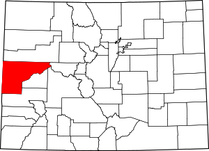 | |
| Towns | ||
| CDPs | ||
| Unincorporated communities | ||
| Ghost towns | ||
This article is issued from
Wikipedia.
The text is licensed under Creative Commons - Attribution - Sharealike.
Additional terms may apply for the media files.