Grand Junction, Colorado
| Grand Junction, Colorado | |
|---|---|
| Home Rule Municipality | |
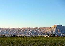
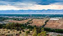 A view of Grand Junction | |
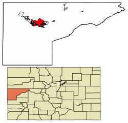 Location of Grand Junction in Mesa County, Colorado. | |
 Grand Junction, Colorado Location in the United States | |
| Coordinates: 39°04′N 108°34′W / 39.067°N 108.567°WCoordinates: 39°04′N 108°34′W / 39.067°N 108.567°W | |
| Country | United States |
| State | Colorado |
| County | Mesa[1] |
| Incorporated | July 22, 1882[2] |
| Named for | Confluence of Grand River and Gunnison River |
| Government | |
| • Type | Home Rule Municipality |
| • Mayor | Rick Taggart since May 4, 2017 |
| • City Manager | Greg Caton |
| Area[3] | |
| • Home Rule Municipality | 39.64 sq mi (102.66 km2) |
| • Land | 39.28 sq mi (101.74 km2) |
| • Water | 0.36 sq mi (0.92 km2) |
| • Metro | 3,341.11 sq mi (8,653 km2) |
| Elevation | 4,593 ft (1,397 m) |
| Population (2010) | |
| • Home Rule Municipality | 58,566 |
| • Estimate (2016)[4] | 61,881 |
| • Density | 1,575.38/sq mi (608.25/km2) |
| • Metro | 147,083 |
| • Metro density | 44/sq mi (17/km2) |
| Time zone | UTC−7 (MST) |
| • Summer (DST) | UTC−6 (MDT) |
| ZIP codes[5] | 81501-81507 |
| Area code(s) | 970 |
| FIPS code | 08-31660 |
| GNIS feature ID | 0204662 |
| Highways | I-70, U.S. Highway 6 , U.S. Highway 50 , CO SH 340, CO SH 141, CO SH 139 |
| Website | City of Grand Junction |
|
| |
Grand Junction is the home rule municipality that is the county seat and the most populous municipality of Mesa County, Colorado, United States. The city has a council–manager form of government, and is the most populous municipality in all of western Colorado.[6] Grand Junction is situated 247 miles (398 km) west-southwest of the Colorado State Capitol in Denver. As of the 2010 census, the population of the city was 58,566.[7] Grand Junction is the 15th most populous city in the state of Colorado and the most populous city on the Colorado Western Slope. Grand Junction serves as a major commercial and transportation hub within the large area between the Green River and the Continental Divide. It is the principal city of the Grand Junction Metropolitan Statistical Area which had a population of 146,723 in 2010 census.
The city is located along the Colorado River, at its confluence with the Gunnison River which comes in from the south. The name "Grand" refers to the historical Grand River; it was renamed as the Upper Colorado River in 1921. The word "Junction" refers to the confluence of the Colorado and Gunnison rivers. Grand Junction has been nicknamed "River City". The city is located near the midpoint of a 30-mile (48 km) arcing valley, known as the Grand Valley; since the late 19th century it has been a major fruit-growing region. Historically the valley was long occupied by the Ute people and by earlier indigenous cultures. It was not settled by white European-American farmers until the 1880s. Since the late 20th century, several wineries have been established in the area.
The Colorado National Monument, a unique series of canyons and mesas, overlooks the city on the west. Most of the area is surrounded by federal public lands managed by the US Bureau of Land Management. The Book Cliffs are a prominent series of cliffs that define the northern side of the Grand Valley. Interstate 70 connects the city eastward to Glenwood Springs and Denver and westward to Green River, Utah; Salt Lake City is reached to the west via Interstate 70 and U.S Route 6; and Las Vegas (via Interstate 70 and Interstate 15).
The Country Jam Ranch is located near Grand Junction just north of I-70 at the Mack exit. This is a permanent festival site built for music festivals, including Country Jam. This event has been held annually since 1992, drawing thousands of country music fans to the area.[8]
The Grand Junction area has developed as a mountain biking destination, with many bikers coming from the Front Range of Colorado, the Salt Lake City area, and as far away as California to enjoy the area's abundant single-track trails. Two prominent trails are the Tabeguache and Kokopelli trails, the latter running from near Loma to Moab, Utah. Fruita, Colorado, with its 18-Road trail system, is within 10 miles of the city and has become a major mountain biking destination.
History
In September 1881 the former Ute Indian Territory was abolished and the Utes removed to a reservation so that the U.S. government could open the area to white settlers. Clinton County, Pennsylvania-born George Addison Crawford (1827–91) soon purchased a plot of land.[9] On July 22, 1882 he incorporated the town of Grand Junction, Colorado, and planted the first vineyard in Colo. near Palisade, Colorado, causing the area to become known as the Colorado Wine Country. The City of Grand Junction also has a storied past with gunfighters, miners, and early settlers to the American Southwest. The infamous "Doc" Holliday was buried in the Grand Junction Cemetery after his death from "consumption", (tuberculosis), as Grand Junction was one of his favorite places before he began living full-time at the sanatorium in Glenwood Springs, Colorado.
Geography
According to the United States Census Bureau, the city has a total area of 38.6 square miles (100.0 km2), with 38.2 square miles (99.0 km2) of it land, and 0.39 square miles (1.0 km2), or 0.87% of it water.[10]
Climate
The downtown area displays a semi-arid climate (Köppen BSk), almost grading into an arid type. Grand Junction sits in a large area of high desert lands in Western Colorado. Winters are cold and dry, with a January mean temperature of 27.4 °F (−2.6 °C). Due to its location west of the Rockies, Grand Junction does not receive as much influence from the Chinook winds as locations in Colorado east of the Front Range, yet it does receive protection from the Arctic masses that can settle to the east of the Rockies. This is illustrated by the fact that from December to February, highs reach 50 °F (10 °C) only 18 days.[11] Lows drop to 0 °F (−17.8 °C) or below on 2.9 nights per year.[11] Snowfall is low compared to much of the rest of the state, averaging 19.1 inches (49 cm) per season; only once in the entire period of record dating to 1893, has observed 10 inches (25 cm) in a calendar day, though the median is 6.3 inches (16.0 cm), and moreover, snow cover is intermittent.[11] Snow is greatest in December and January. Spring warming is gradual but quickens when nearing June; the average last freeze date is April 24. Summer is hot but dry, with a July mean temperature of 78.2 °F (25.7 °C). Grand Junction averages 64.5 days a year with temperatures at 90 °F (32 °C) or above, and an average 6.5 days attaining 100 °F (38 °C) or more.[12] Autumn cooling is rapid, with the average first freeze date being October 15. The area receives little precipitation year-round, averaging 9.42 inches (239.3 mm), with no real seasonal spike. Sunshine hours are abundant, even in winter, and total just over 3200 hours per year, or 73% of the possible total.[13]
| Climate data for Grand Junction, Colorado (Grand Junction Regional Airport), 1981–2010 normals, extremes 1893–present[lower-alpha 1] | |||||||||||||
|---|---|---|---|---|---|---|---|---|---|---|---|---|---|
| Month | Jan | Feb | Mar | Apr | May | Jun | Jul | Aug | Sep | Oct | Nov | Dec | Year |
| Record high °F (°C) | 62 (17) |
70 (21) |
81 (27) |
89 (32) |
101 (38) |
105 (41) |
106 (41) |
103 (39) |
100 (38) |
88 (31) |
76 (24) |
66 (19) |
106 (41) |
| Average high °F (°C) | 37.7 (3.2) |
45.4 (7.4) |
56.5 (13.6) |
65.3 (18.5) |
76.1 (24.5) |
87.6 (30.9) |
93.2 (34) |
89.7 (32.1) |
80.1 (26.7) |
66.2 (19) |
50.4 (10.2) |
38.5 (3.6) |
65.6 (18.7) |
| Average low °F (°C) | 17.0 (−8.3) |
23.7 (−4.6) |
31.4 (−0.3) |
38.1 (3.4) |
47.0 (8.3) |
56.3 (13.5) |
63.2 (17.3) |
61.3 (16.3) |
52.0 (11.1) |
39.9 (4.4) |
27.6 (−2.4) |
18.5 (−7.5) |
39.7 (4.3) |
| Record low °F (°C) | −23 (−31) |
−21 (−29) |
5 (−15) |
11 (−12) |
24 (−4) |
34 (1) |
44 (7) |
43 (6) |
28 (−2) |
16 (−9) |
−4 (−20) |
−21 (−29) |
−23 (−31) |
| Average precipitation inches (mm) | 0.58 (14.7) |
0.54 (13.7) |
0.92 (23.4) |
0.91 (23.1) |
0.88 (22.4) |
0.46 (11.7) |
0.61 (15.5) |
0.95 (24.1) |
1.19 (30.2) |
1.06 (26.9) |
0.73 (18.5) |
0.59 (15) |
9.42 (239.3) |
| Average snowfall inches (cm) | 4.9 (12.4) |
3.2 (8.1) |
2.6 (6.6) |
0.9 (2.3) |
0.1 (0.3) |
0 (0) |
0 (0) |
0 (0) |
0 (0) |
0.4 (1) |
2.1 (5.3) |
4.9 (12.4) |
19.1 (48.5) |
| Average precipitation days | 5.9 | 6.2 | 7.3 | 7.3 | 6.4 | 4.1 | 5.3 | 6.7 | 7.0 | 6.5 | 5.9 | 5.7 | 74.3 |
| Average snowy days | 4.7 | 3.6 | 2.4 | 0.9 | 0.1 | 0 | 0 | 0 | 0 | 0.6 | 2.2 | 4.6 | 19.1 |
| Average relative humidity (%) | 69.7 | 60.4 | 50.1 | 40.3 | 36.3 | 29.4 | 33.5 | 36.6 | 38.8 | 45.6 | 58.5 | 68.0 | 47.3 |
| Mean monthly sunshine hours | 192.3 | 204.4 | 240.9 | 278.0 | 328.5 | 359.3 | 356.2 | 329.8 | 292.2 | 255.1 | 186.9 | 180.0 | 3,203.6 |
| Percent possible sunshine | 63 | 68 | 65 | 70 | 74 | 81 | 79 | 78 | 78 | 74 | 62 | 61 | 72 |
| Source: NOAA (sun 1961–1990),[11][14][15] The Weather Channel[16] | |||||||||||||
Demographics
| Historical population | |||
|---|---|---|---|
| Census | Pop. | %± | |
| 1890 | 2,030 | — | |
| 1900 | 3,503 | 72.6% | |
| 1910 | 7,754 | 121.4% | |
| 1920 | 8,665 | 11.7% | |
| 1930 | 10,247 | 18.3% | |
| 1940 | 12,479 | 21.8% | |
| 1950 | 14,504 | 16.2% | |
| 1960 | 18,694 | 28.9% | |
| 1970 | 20,170 | 7.9% | |
| 1980 | 27,956 | 38.6% | |
| 1990 | 29,034 | 3.9% | |
| 2000 | 41,986 | 44.6% | |
| 2010 | 58,566 | 39.5% | |
| Est. 2016 | 61,881 | [4] | 5.7% |
| U.S. Decennial Census[17] | |||
According to the census.gov website the estimate population as of July 1, 2017 is 62,475 people.[18] As of the census[19] of 2000, there were 41,986 people, 17,865 households, and 10,540 families residing in the city. The population density was 1,362.6 people per square mile (526.2/km²). There were 18,784 housing units at an average density of 609.6 per square mile (235.4/km²). The racial makeup of the city was 91.78% White, 0.60% African American, 0.94% Native American, 0.76% Asian, 0.12% Pacific Islander, 3.81% from other races, and 1.99% from two or more races. Hispanic or Latino of any race were 10.86% of the population.
There were 17,865 households out of which 25.5% had children under the age of 18 living with them, 46.1% were married couples living together, 9.4% had a female householder with no husband present, and 41.0% were non-families. 33.2% of all households were made up of individuals and 13.8% had one living alone who was 65 years of age or older. The average household size was 2.23 and the average family size was 2.84.
In the city, the population was spread out with 21.2% under the age of 18, 11.9% from 18 to 24, 26.3% from 25 to 44, 22.8% from 45 to 64, and 17.9% who were 65 years of age or older. The median age was 39 years. For every 100 females, there were 95.1 males. For every 100 females age 18 and over, there were 92.6 males.
The population figures are for Grand Junction only; the city abuts smaller towns and unincorporated county areas which contribute to area commerce.
The median income for a household in the city was $33,152, and the median income for a family was $43,851. Males had a median income of $31,685 versus $22,804 for females. The per capita income for the city was $19,692. About 7.5% of families and 11.9% of the population were below the poverty line, including 11.8% of those under age 18 and 9.0% of those age 65 or over.
Economy
Economic history
From the time settlers arrived in the 1880s until the 1960s, three of the main economic activities in the region were farming, fruit growing, and cattle raising. Fruit orchards, particularly between Grand Junction and Palisade to the east, remain important to the region's reputation and economy to the present day. Fruits most often grown are peaches, pears, apricots, plums, cherries, and, particularly since the 1980s, grapes for wine. In this semi-arid environment, these orchards thrive from a combination of abundant sunshine and irrigation from a system of canals that divert water from the Colorado River.
Retail sales have been important to the economy for decades (e.g., gasoline, and hunting and fishing related sales), and uranium mining-related activities have also been significant.[20] Grand Junction was home to the Climax Uranium Mill, a now decommissioned mill that provided uranium ore to the US Atomic Energy Commission.
Education and healthcare have been important to the economy of the area, especially since the 1950s, with the rise of Colorado Mesa University and St. Mary's Hospital as leading employers in these fields.
Vast oil shale reserves were known to exist near Parachute, Colorado in the Piceance Basin. The oil embargoes of the 1970s and high gas prices resulted in major financial interest in the region. Exxon purchased rights and used Grand Junction as its seat of operations. The city and the surrounding Grand Valley became prosperous in the 1970s and early 1980s largely because of the effects of oil shale development. The United States, western Colorado in particular, has the largest-known concentration of oil shale in the world (according to the Bureau of Land Management) and holds an estimated 800 gigabarrels of recoverable oil, enough to meet U.S. demand for oil at current levels for 110 years. Known as the "Rock That Burns," the shale can be mined and processed to produce oil. In the past it was significantly more expensive than conventional oil. Sustained prices above $95 per barrel, however, may make extraction economically attractive in the coming years (see Oil Shale Economics). ExxonMobil pulled out of the region because of lower oil prices, which led to economic hardship in the region.
The economic bust, known as "Black Sunday" (May 2, 1982) to the locals, started with a phone call from the president of Exxon to Governor Richard Douglas Lamm, stating that Exxon would cut its losses while retaining mining rights to the (then and currently) uneconomic oil. The economic bust was felt statewide, as Exxon had invested more than 5 billion USD in the state. Colorado historian Tom Noel observed, "I think that was a definite turning point, and it was a reminder that we were a boom-and-bust state...There were parallels to the silver crash of 1893."[21]
By 2008, the economy of Grand Junction appeared to be more diverse and stable than it had been in previous decades. Major contributors to the economy were health care, tourism, agriculture, livestock, and energy mining (gas and oil). Major energy companies had once again invested large amounts of money due to increases in oil and natural gas prices (such as in the years 2005–2008). However, a major drop (in the summer of 2008) of market natural gas prices led to reduced gas well drilling and related capital expenditures in the area, significantly slowing the Grand Junction economy in 2009. Reports given in 2009 suggested that Grand Junction had once again been hard-hit economically, with one report by April 2010 listing the area as having had the largest percentage drop in employment of any "small city" in the entire United States.[22]
By 2008, Grand Junction was being discovered by the "nation's elite business and leisure travelers" as a destination for private jet travel, with nearby Powderhorn Resort and other ski resorts a major attraction.[23]
Top employers
According to the City's 2011 Comprehensive Annual Financial Report,[24] the top employers are:
| # | Employer | Percentage of Total Employees | Number of Employees |
|---|---|---|---|
| 1 | Mesa County Valley School District 51 | 3.53% | 2554 |
| 2 | City Market | 2.29% | 1656 |
| 3 | St. Mary's Hospital | 2.07% | 1494 |
| 4 | State of Colorado | 1.35% | 973 |
| 5 | Mesa County | 1.33% | 962 |
| 6 | Halliburton | 1.18% | 855 |
| 7 | Walmart | 1.07% | 775 |
| 8 | City of Grand Junction | 0.86% | 625 |
| 9 | VA Medical Center | 0.83% | 609 |
| 10 | Community Hospital | 0.81% | 583 |
Notable residents
- Doc Holliday, John Henry Holliday was an infamous member of the Wyatt Earp U.S. Marshalls group.
- Owen Aspinall, former Governor of American Samoa, was born in Grand Junction, the son of long-time U.S Representative Wayne N. Aspinall
- Charles L. Fletcher, architect and interior designer; owner of Charles Fletcher Design
- Ben Garland, NFL player
- Vance Johnson, former NFL wide receiver
- Aryn Kyle, bestselling author of The God of Animals[25]
- Annabelle Craft Moss (1921–2015), an aviator who won the Congressional Gold Medal, and pilot in World War II with the Women Airforce Service Pilots (WASPs)
- Rick Schroder owned a home outside of Grand Junction during the mid to late 1990s
- Michael Strobl, United States Marine, subject of a film (Taking Chance)
- Dalton Trumbo (1905–1976), Academy Award-winning screenwriter (Exodus, Spartacus, Roman Holiday, Thirty Seconds Over Tokyo), novelist (Johnny Got His Gun) and member of the Hollywood Ten. His childhood home was located at 1124 Gunnison Avenue in Grand Junction. He is honored with a Dalton Trumbo Free Speech Fountain on the campus of his alma mater, the University of Colorado. His first novel, Eclipse (1934), was set in a fictional town based on an unflattering Grand Junction, and many of the characters are identifiable as community leaders. A statue commemorating the loved and hated Trumbo is on Main Street in front of the Avalon Theater.[26]
- Walter Walker, political leader and publisher made Grand Junction his home for many years. For three months in 1932, he served as one of Colorado's US Senators, and was publisher and primary owner of the Grand Junction Daily Sentinel newspaper.
Education
K-12
The Mesa Valley School District No. 51 (website) provides comprehensive K-12 public education to the Grand Junction area. School District 51 operates five high schools:
- Fruita Monument High School
- Grand Junction High School
- Central High School
- Palisade High School
- R-5 High School
In addition, the district operates numerous middle, elementary, and other types of schools. District 51 partners with the Western Colorado Community College (WCCC) to operate a vocational school, owned and operated by Colorado Mesa University. The WCCC was formerly named UTEC.
Colleges and universities
Colorado Mesa University, a public, four-year, liberal arts college, serves as the primary provider of higher education on the Western Slope from its campus in central Grand Junction. This campus has an average enrollment of just under 10,000 students and offers a variety of degrees, including a Masters in Business Administration, Educational Leadership, and ESOL.
Sports
Grand Junction's Colorado National Monument was home to a stage in the Coors Classic bicycle race known as "The Tour of the Moon" due to the Monument's unique landscape.
Since 1958, the JUCO World Series has been playing at Suplizio Field. Most recently at Suplizio Field, a new professional Minor League Baseball team affiliate of the Colorado Rockies in the Pioneer Baseball League came from Casper and are known as the Grand Junction Rockies.
Adjacent to Suplizio Field, Stocker Stadium is home to the semi-professional Grand Junction Gladiators football team.
Both Suplizio Field and Stocker Stadium also host Colorado Mesa University as well as School District 51 sporting events.
Transportation
Grand Junction Regional Airport (formerly Walker Field Airport) serves as the major airport in the area. The airport is located in north Grand Junction on Horizon Drive. As of 2011, two-way flights to Denver, Salt Lake City, Las Vegas, Dallas, Phoenix, Los Angeles, and Houston were available.
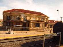
Amtrak, the national passenger rail system, provides service to Grand Junction Station, operating its California Zephyr daily in both directions between Chicago and Emeryville, California, across the bay from San Francisco.
The Grand Valley Transit (GVT) is a regional transit system serving the grand valley. It operates 11 bus routes in the area as well as a "dial-a-ride" service.
Major highways


Rankings
Grand Junction, Colorado has placed number six in Outdoor Life's 2012 list of The 35 Best Hunting and Fishing Towns in the US, number twelve in Forbes 2012 list of The Best Small Places For Business and Careers, number five in The New York Times 2011 list of Where to Live to Avoid a Natural Disaster, and number seven in Tourism-Review.com's 2009 list of the 8 Sunniest Cities in the USA.[27]
Media
Radio
The Grand Junction radio market includes all of Mesa County, Colorado.[28] Six AM radio stations and more than 25 FM stations are licensed to broadcast from the city.[29][30]
Newspapers
Grand Junction is serviced by one local newspaper, The "Grand Junction Daily Sentinel". The Grand Junction area also receives newspaper influence from sources in the greater Denver front range area.
Television
Grand Junction has ABC, NBC, and CBS television station affiliates under the call signs of KJCT-TV (Channel 8), KKCO-TV (Channel 11), and KREX-TV (Channel 5) respectively. Also, Grand Junction has a Fox (Channel 4) affiliate station under the call sign of KFQX that receives news from the Denver FOX affiliate, KDVR (Channel 31) at 9 pm. KGBY (Channel 20) broadcasts Cozi TV programming. KRMJ (Channel 18) is the local PBS affiliate, part of the statewide Rocky Mountain PBS network.
Venues
Grand Junction's downtown is home to the historic Avalon theater as well as Mesa Theater, Quincy Bar and Charlie Dwellingtons which hold the majority of live music, most of which is performed by Brandon Moncy or his company: American Eagle Entertainment.
See also
Notes
References
- ↑ "Active Colorado Municipalities". State of Colorado, Department of Local Affairs. Archived from the original on 2010-11-23. Retrieved 2007-09-01.
- ↑ "Colorado Municipal Incorporations". State of Colorado, Department of Personnel & Administration, Colorado State Archives. 2004-12-01. Retrieved 2007-09-02.
- ↑ "2016 U.S. Gazetteer Files". United States Census Bureau. Retrieved Jul 25, 2017.
- 1 2 "Population and Housing Unit Estimates". Retrieved June 9, 2017.
- ↑ "ZIP Code Lookup". United States Postal Service. Archived from the original (JavaScript/HTML) on November 23, 2010. Retrieved September 24, 2007.
- ↑ "Find a County". National Association of Counties. Archived from the original on 2011-05-31. Retrieved 2011-06-07.
- ↑ "Profile of General Population and Housing Characteristics: 2010 Demographic Profile Data (DP-1): Grand Junction city, Colorado". U.S. Census Bureau, American Factfinder. Archived from the original on September 11, 2013. Retrieved November 22, 2011.
- ↑ Grand Junction Area Chamber of Commerce
- ↑ Kansas: A Cyclopedia of State History, Embracing Events, Institutions, Industries, Counties, Cities, Towns, Prominent Persons, Etc. by Frank Wilson Blackmar, Standard Publishing Company, 1912, page 474
- ↑ "Geographic Identifiers: 2010 Demographic Profile Data (G001): Grand Junction city, Colorado". U.S. Census Bureau, American Factfinder. Archived from the original on September 11, 2013. Retrieved November 22, 2011.
- 1 2 3 4 "NowData – NOAA Online Weather Data". National Oceanic and Atmospheric Administration. Retrieved 2014-03-04.
- ↑ "GRAND JUNCTION WALKER AP, CO". In Climatography of the United States No. 20 1971–2000. U.S. Department of Commerce, National Oceanic & Atmospheric Administration, National Environmental Satellite, Data and Information Service.
- ↑ "Climatological Normals of Grand Junction". Hong Kong Observatory. Archived from the original on 2012-03-20. Retrieved 2010-05-18.
- ↑ "Station Name: CO GRAND JUNCTION WALKER FLD". National Oceanic and Atmospheric Administration. Retrieved 2014-03-29.
- ↑ "WMO Climate Normals for GRAND JUNCTION/WALKER FIELD CO 1961–1990". National Oceanic and Atmospheric Administration. Retrieved 2014-03-11.
- ↑ "Monthly Averages for Grand Junction, CO – Temperature and Precipitation". The Weather Channel. Retrieved 2008-11-02.
- ↑ "Census of Population and Housing". Census.gov. Archived from the original on May 12, 2015. Retrieved June 4, 2015.
- ↑ "U.S. Census Bureau QuickFacts: Grand Junction city, Colorado". Census Bureau QuickFacts. Retrieved 2018-06-26.
- ↑ "American FactFinder". United States Census Bureau. Archived from the original on 2013-09-11. Retrieved 2008-01-31.
- ↑ History Timeline. Museum of Western Colorado
- ↑ Richard Williamson (October 5, 1999). "Oil shale collapse preserved scenic vistas". Denver Rocky Mountain News. Archived from the original on June 27, 2009. Retrieved June 3, 2009.
- ↑ The Adams Group, Coloradoeconomy.com, "Today's Economy" Archived 2008-05-11 at the Wayback Machine.. April 23, 2010. Retrieved 5-12-2010
- ↑ "Colo. gets two spots on luxury-travel list". – Denver Business Journal. – January 11, 2008. – Retrieved 2008-01-12
- ↑ "City of Grand Junction CAFR". Archived from the original (PDF) on 2014-03-06. Retrieved 2012-08-12.
- ↑ http://writersalmanac.publicradio.org/index.php?date=2010/01/22
- ↑ Nichols, Josh (2007-10-14) Trumbo sculpture unveiled Archived 2013-11-02 at the Wayback Machine.. Post Independent. Retrieved on 2013-08-23.
- ↑ "Facts and Rankings – Grand Junction Economic Partnership". Grand Junction Economic Partnership. Archived from the original on May 6, 2012. Retrieved June 29, 2012.
- ↑ "2012 Arbitron Radio Metro Map" (PDF). Arbitron. Retrieved 2014-08-25.
- ↑ "AMQ AM Radio Database Query". Federal Communications Commission. Archived from the original on 2009-08-25. Retrieved 2014-08-25.
- ↑ "Radio Stations in Grand Junction, Colorado". Radio-Locator. Retrieved 2014-08-25.
External links
| Wikimedia Commons has media related to Grand Junction, Colorado. |
| Wikivoyage has a travel guide for Grand Junction. |
- City of Grand Junction website
- CDOT map of the City of Grand Junction
- GJSentinel.com/The Daily Sentinel (daily newspaper)
- krextv.com/ (local television news)
- Community.GJSentinel.com (community forums and letters)
- Grand Junction Business Directory (local business directory)
- KAFM Community Radio (Non-profit, volunteer radio station)
- Grand Junction VCB (Visitor and Convention Information)
- "Grand Junction, Colorado". C-SPAN Cities Tour. September 2015.
Places adjacent to Grand Junction, Colorado | |
|---|---|
Municipalities and communities of Mesa County, Colorado, United States | ||
|---|---|---|
| Cities | 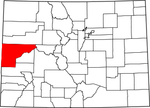 | |
| Towns | ||
| CDPs | ||
| Unincorporated communities | ||
| Ghost towns | ||
