Barstow, Fresno County, California
Coordinates: 36°48′55″N 119°58′12″W / 36.81528°N 119.97000°W
| Barstow | |
|---|---|
| Unincorporated community | |
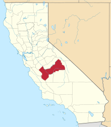
 Barstow Location in California  Barstow Barstow (the US) | |
| Coordinates: 36°48′55″N 119°58′12″W / 36.81528°N 119.97000°W | |
| Country | United States |
| State | California |
| County | Fresno County |
| Elevation[1] | 276 ft (84 m) |
Barstow is an unincorporated community in Fresno County, California.[1] It is located 3.25 miles (5 km) west-southwest of Herndon,[2] at an elevation of 276 feet (84 m).[1] The main street running through Barstow is West Barstow Avenue.[3] It covers part of zipcode 93723, along with parts of Pratton, Herndon and Biola.[4] This zipcode includes 36 businesses, 3028 single-family occupancies and a population of 9,724. The diversity index is 85 (on a scale from 0-100).[5]
References
- 1 2 3 U.S. Geological Survey Geographic Names Information System: Barstow, Fresno County, California
- ↑ Durham, David L. (1998). California's Geographic Names: A Gazetteer of Historic and Modern Names of the State. Clovis, Calif.: Word Dancer Press. p. 998. ISBN 1-884995-14-4.
- ↑ "Barstow". Google Maps. Retrieved 20 December 2015.
- ↑ "Fresno Zipmap". Zipmap. Retrieved 20 December 2015.
- ↑ "93723 ZIP Code Demographics & Rankings". Hometownlocator.com. Retrieved 20 December 2015.
This article is issued from
Wikipedia.
The text is licensed under Creative Commons - Attribution - Sharealike.
Additional terms may apply for the media files.