Mono Hot Springs, California
| Mono Hot Springs | |
|---|---|
| Unincorporated community | |
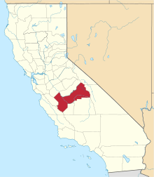
 Mono Hot Springs Location in California | |
| Coordinates: 37°19′36″N 119°01′03″W / 37.32667°N 119.01750°WCoordinates: 37°19′36″N 119°01′03″W / 37.32667°N 119.01750°W | |
| Country | United States |
| State | California |
| County | Fresno County |
| Elevation[1] | 6,562 (6,700) ft (2,000 m) |
Mono Hot Springs (formerly Lower Hot Springs and Lower Mineral Hot Springs)[2] is a summer resort, campground, unincorporated community, and a group of hot springs in Fresno County, central California.[1] It is located within the Sierra National Forest, 70 miles (110 km) northeast of Fresno via California State Route 168.[3]
History
The Mono Hot Springs post office was established in 1945.[2] It, a general store, and stone cabins are located at the rustic Mono Hot Springs Resort.[4] Listed on the National Register of Historic Places, the resort was built in 1935, a few years after Southern California Edison completed this section of the Kaiser Pass Road for the Big Creek Hydroelectric Project.[5]
Geography
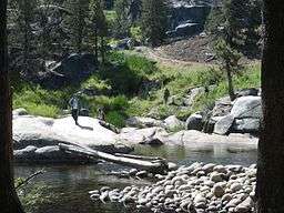
Mono Hot Springs lies at an elevation of 6,700 feet (2,000 m), in the central Sierra Nevada.[1][3] There are six separate hot springs, with the hottest 112 °F (44.4 °C).[2] The public springs are on the hillside across the South Fork of the San Joaquin River from the campground and resort.
The locale is between Florence Lake and Lake Thomas A Edison reservoirs of the Big Creek Hydroelectric Project. It is reached via the forest service's Kaiser Pass Road, 17 miles (27 km) northeast from its start at Huntington Lake.[3] The road crosses the 9,175 feet (2,797 m) Kaiser Pass before reaching the hot springs and reservoirs.

Recreation
The Sierra National Forest's Mono Hot Springs Campground is located adjacent to the springs and resort, on the river.[6] The Mono Creek Campground, is in the vicinity to the north, on a meadow along Mono Creek.[7] Ward Lake and Jackass Meadow Campgrounds in the area.[8][9]
Mono Hot Springs is a trailhead for hiking trails to local mountains, a volcanic plug, lakes, and to reach the Ansel Adams Wilderness area on the north and John Muir Wilderness area on the east.[10]
Natural history
Large rounded rock formations of Sierra granite predominate the terrain, rising above the vegetation and river.
Flora
The Mono Hot Springs Evening-primrose, Camissonia sierrae subsp. alticola, is endemic and limited to this area and several sites in Yosemite National Park.[11] It is listed on the California Native Plant Society Inventory of Rare and Endangered Plants of California.[12]
Predominant trees in the surrounding forest include Sierra lodgepole pines (Pinus contorta) and Ponderosa pines (Pinus ponderosa).
See also
References
- 1 2 3 "Mono Hot Springs". Geographic Names Information System. United States Geological Survey.
- 1 2 3 Durham, David L. (1998). California's Geographic Names: A Gazetteer of Historic and Modern Names of the State. Clovis, Calif.: Word Dancer Press. p. 1074. ISBN 1-884995-14-4.
- 1 2 3 Sierra National Forest
- ↑ monohotsprings.com
- ↑ Sunset Magazine: "Follow Kaiser Pass Road to the heart of the Central Sierra" Archived 2014-10-27 at the Wayback Machine.
- ↑ USFS: Mono Hot Springs Campground
- ↑ USFS: Mono Creek Campground
- ↑ Berkeley.edu, Fresh Faces Blog: "Mono Hot Springs" Archived 2014-07-14 at the Wayback Machine.
- ↑ Public Lands Information Center: Ward Lake Campground
- ↑ Sierra National Forest: Mono Creek Trailhead
- ↑ CalFlora Database: Camissonia sierrae subsp. alticola (Mono Hot Springs Evening-primrose)
- ↑ CNPS—California Native Plant Society Inventory Plant Detail: Camissonia sierrae ssp. alticola
External links
- Mono Hot Springs Resort website
- Sierra National Forest: Mono Hot Springs Campground
- Recreation.gov: Mono Hot Springs, campground
- Recreation.gov: Mono Hot Springs, campground map