Bridgeport, California
| Bridgeport, California | |
|---|---|
| Census designated place and county seat | |
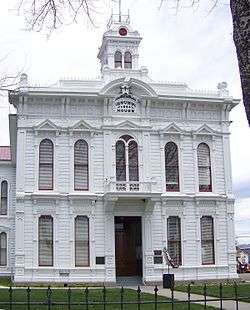 The Mono County Court House in Bridgeport | |
 Bridgeport, California Location in California | |
| Coordinates: 38°15′21″N 119°13′53″W / 38.25583°N 119.23139°WCoordinates: 38°15′21″N 119°13′53″W / 38.25583°N 119.23139°W | |
| Country | United States |
| State | California |
| County | Mono |
| Area[1] | |
| • Total | 21.75 sq mi (56.33 km2) |
| • Land | 21.74 sq mi (56.31 km2) |
| • Water | 0.01 sq mi (0.02 km2) 0.04% |
| Elevation[2] | 6,463 ft (1,970 m) |
| Population (2010) | |
| • Total | 575 |
| • Estimate (2016)[3] | N/A |
| Time zone | UTC-8 (Pacific) |
| • Summer (DST) | UTC-7 (PDT) |
| ZIP code | 93517 |
| Area codes | 442/760 |
| GNIS feature IDs | 1658134, 2582950 |
| [2][4] | |
Bridgeport is a census-designated place (CDP)[4] in and the county seat of Mono County, California, United States.[5] It lies at an elevation of 6463 feet (1970 m) in the middle of the Bridgeport Valley.[2] Bridgeport is located at the intersection of U.S. Route 395 and State Route 182. The population was 575 at the 2010 census.
Geography and features

The first post office at Bridgeport opened in 1864.[6] The ZIP code is 93517, and the community is in area codes 442 and 760. According to the United States Census Bureau, the CDP covers an area of 21.7 sq mi (56.3 km2), 99.96% of it land, and 0.04% of it water. The US Marine Corps' Mountain Warfare Training Center is located approximately 20 miles (32 km) west of Bridgeport on State Route 108.
Demographics
The 2010 United States Census[7] reported that Bridgeport had a population of 575. The population density was 26.4 people per square mile (10.2/km²). The racial makeup of Bridgeport was 484 (84.2%) White, 1 (0.2%) African American, 43 (7.5%) Native American, 1 (0.2%) Asian, 0 (0.0%) Pacific Islander, 25 (4.3%) from other races, and 21 (3.7%) from two or more races. Hispanic or Latino of any race were 148 persons (25.7%).
The Census reported that 559 people (97.2% of the population) lived in households, 0 (0%) lived in non-institutionalized group quarters, and 16 (2.8%) were institutionalized.
There were 257 households, out of which 67 (26.1%) had children under the age of 18 living in them, 124 (48.2%) were opposite-sex married couples living together, 22 (8.6%) had a female householder with no husband present, 9 (3.5%) had a male householder with no wife present. There were 12 (4.7%) unmarried opposite-sex partnerships, and 1 (0.4%) same-sex married couples or partnerships. 88 households (34.2%) were made up of individuals and 26 (10.1%) had someone living alone who was 65 years of age or older. The average household size was 2.18. There were 155 families (60.3% of all households); the average family size was 2.83.
The population was spread out with 119 people (20.7%) under the age of 18, 46 people (8.0%) aged 18 to 24, 118 people (20.5%) aged 25 to 44, 193 people (33.6%) aged 45 to 64, and 99 people (17.2%) who were 65 years of age or older. The median age was 45.5 years. For every 100 females, there were 103.2 males. For every 100 females age 18 and over, there were 104.5 males.
There were 357 housing units at an average density of 16.4 per square mile (6.3/km²), of which 160 (62.3%) were owner-occupied, and 97 (37.7%) were occupied by renters. The homeowner vacancy rate was 5.3%; the rental vacancy rate was 19.0%. 341 people (59.3% of the population) lived in owner-occupied housing units and 218 people (37.9%) lived in rental housing units.
Tourism
Formerly known as Big Meadows, Bridgeport is annually visited by thousands of tourists, many of whom come to the area for its well-known trout streams and lakes. Bridgeport Reservoir, Twin Lakes,[8]], Virginia Lakes, Green Creek, the East Walker River, the West Walker River and numerous small tributaries and backcountry lakes offer rainbow, brown and cutthroat trout fishing. The Bridgeport Fish Enhancement Program sponsors fishing tournaments twice per season. Bridgeport also occasionally plays host to the annual E Clampus Vitus celebration.
Bridgeport is known for its backcountry winter recreation. Over 500 miles of cross-country skiing, snowshoeing, dogsledding, snowmobiling and multiple-use trails are found around the town, including Virginia Lakes Road, the Sweetwater Range, Buckeye, Bodie Hills and Summers Meadows. Many backcountry bowls can be used for telemarking and cross-country downhilling. Bridgeport is also notable for its proximity to the well-preserved ghost town of Bodie. The Mono County Courthouse is listed on the National Register of Historic Places.
Climate
Bridgeport experiences a humid continental climate (Dsb) and featuring cold, relatively snowy winters and dry summers with very warm days and cold mornings.
Average January temperatures in Bridgeport are a maximum of 41.2 °F or 5.1 °C and a minimum of 8.6 °F or −13.0 °C. Average July temperatures are a maximum of 82.9 °F or 28.3 °C and a minimum of 40.2 °F or 4.6 °C. There are an average of 5.6 days with highs of 90 °F (32.2 °C) or higher and 13.1 days where the high does not top freezing. With the high altitude, nights are extremely cold, with an average of 255.7 mornings with lows of 32 °F (0 °C) or lower and 19.2 mornings with lows under 0 °F or −17.8 °C. The record high temperature of 98 °F (36.7 °C) was on July 28, 1944. The record low temperature of −36 °F (−37.8 °C) occurred on January 31, 1916.[9]
Average annual precipitation is 9.41 inches or 239.0 millimetres. There are an average of 40 days with measurable precipitation. The wettest “rain year” was from July 1968 to June 1969 with 20.76 inches (527.3 mm) and the driest from July 1959 to June 1960 with 4.37 inches (111.0 mm). The most precipitation in one month was 7.69 inches (195.3 mm) during January 1969. The most precipitation in 24 hours was 2.59 inches or 65.8 millimetres on January 31, 1963. Average annual snowfall is 49.5 inches or 1.26 metres. The most snowfall in one year was 174.06 inches or 4.42 metres between July 1915 and June 1916, including 121.0 inches or 3.07 metres in January 1916. The maximum snow cover was 51 inches or 1.30 metres on February 25, 1969.[9]
| Climate data for Bridgeport, California, 1981-2010 normals, extremes 1903-present | |||||||||||||
|---|---|---|---|---|---|---|---|---|---|---|---|---|---|
| Month | Jan | Feb | Mar | Apr | May | Jun | Jul | Aug | Sep | Oct | Nov | Dec | Year |
| Record high °F (°C) | 68 (20) |
71 (22) |
77 (25) |
84 (29) |
88 (31) |
94 (34) |
98 (37) |
96 (36) |
91 (33) |
89 (32) |
80 (27) |
72 (22) |
98 (37) |
| Mean maximum °F (°C) | 55.4 (13) |
56.9 (13.8) |
63.8 (17.7) |
72.7 (22.6) |
79.1 (26.2) |
86.7 (30.4) |
91.2 (32.9) |
90.0 (32.2) |
85.4 (29.7) |
79.2 (26.2) |
69.5 (20.8) |
59.4 (15.2) |
91.8 (33.2) |
| Average high °F (°C) | 40.7 (4.8) |
44.3 (6.8) |
51.2 (10.7) |
59.0 (15) |
66.8 (19.3) |
75.7 (24.3) |
83.6 (28.7) |
82.4 (28) |
75.6 (24.2) |
65.5 (18.6) |
52.7 (11.5) |
42.4 (5.8) |
61.7 (16.5) |
| Daily mean °F (°C) | 24.4 (−4.2) |
28.0 (−2.2) |
35.0 (1.7) |
41.5 (5.3) |
48.5 (9.2) |
56.3 (13.5) |
62.5 (16.9) |
60.8 (16) |
53.7 (12.1) |
44.1 (6.7) |
34.4 (1.3) |
26.2 (−3.2) |
43.0 (6.1) |
| Average low °F (°C) | 8.1 (−13.3) |
11.7 (−11.3) |
18.8 (−7.3) |
23.9 (−4.5) |
30.2 (−1) |
36.9 (2.7) |
41.4 (5.2) |
39.2 (4) |
31.8 (−0.1) |
22.8 (−5.1) |
16.1 (−8.8) |
10.0 (−12.2) |
24.3 (−4.3) |
| Mean minimum °F (°C) | −13.5 (−25.3) |
−9.6 (−23.1) |
0.8 (−17.3) |
11.1 (−11.6) |
17.5 (−8.1) |
25.3 (−3.7) |
31.5 (−0.3) |
29.7 (−1.3) |
21.0 (−6.1) |
11.0 (−11.7) |
0.9 (−17.3) |
−9.0 (−22.8) |
−21.8 (−29.9) |
| Record low °F (°C) | −37 (−38) |
−29 (−34) |
−26 (−32) |
−2 (−19) |
6 (−14) |
17 (−8) |
21 (−6) |
19 (−7) |
7 (−14) |
−5 (−21) |
−20 (−29) |
−31 (−35) |
−37 (−38) |
| Average precipitation inches (mm) | 1.25 (31.8) |
1.63 (41.4) |
0.97 (24.6) |
0.46 (11.7) |
0.48 (12.2) |
0.28 (7.1) |
0.33 (8.4) |
0.46 (11.7) |
0.45 (11.4) |
0.33 (8.4) |
1.06 (26.9) |
1.70 (43.2) |
9.40 (238.8) |
| Average snowfall inches (cm) | 5.4 (13.7) |
5.4 (13.7) |
2.9 (7.4) |
1.8 (4.6) |
0.3 (0.8) |
0 (0) |
0 (0) |
0.2 (0.5) |
0 (0) |
0 (0) |
2.2 (5.6) |
5.1 (13) |
24.4 (62) |
| Average precipitation days (≥ 0.01 in) | 4.7 | 5.2 | 4.0 | 3.3 | 2.5 | 2.0 | 1.8 | 2.5 | 2.0 | 2.0 | 2.8 | 4.2 | 37.0 |
| Average snowy days (≥ 0.1 in) | 2.3 | 2.3 | 1.3 | 0.8 | 0.1 | 0 | 0 | 0 | 0 | 0.2 | 0.7 | 2.2 | 9.9 |
| Source: NOAA[9][10] | |||||||||||||
Politics
State
In the California State Legislature, Bridgeport is in the 8th Senate District, represented by Republican Tom Berryhill, and in the 5th Assembly District, represented by Republican Frank Bigelow.[11]
Federal
Bridgeport is in California's 8th congressional district, represented by Republican Paul Cook.[12]
Indian
Bridgeport is the tribal headquarters for the Bridgeport Paiute Indian Colony of California.[13]
Education
Bridgeport is in the Eastern Sierra Unified School District, which has its main office in town.[14] An elementary school and a high school (Eastern Sierra Academy[15]) are located in Bridgeport.[14] Bridgeport also has a public library.[14]
Bridgeport in fiction
Bridgeport is the setting of the 1947 film Out of the Past; several sequences were filmed on location in the town.
Bridgeport plays a small role in the novel The Dharma Bums (1958) by Jack Kerouac; it is the place from where the main characters Ray Smith, Japhy Ryder and Henry Morley start their climb to the nearby Matterhorn Peak.
Bridgeport is also mentioned in the 1973 supernatural thriller novel The Reincarnation of Peter Proud by Max Ehrlich. The protagonist, a Native American studies professor at UCLA, is distracted by various memories of a previous life recalled constantly and involuntarily in the form of dreams whenever he falls asleep to the point where it begins to detract from his ability to function. He is called as an expert witness on behalf of a local band of Paiute Native Americans at a court hearing in Bridgeport and bungles it.
Bridgeport in 1867 is the setting for the 2017 historical fiction novel, Heartwood, by JoAnn Conner. The main character, Matthew Raines recruits the townspeople, including the historic figure of Sheriff Zachary Tinkum, to solve a murder and mystery. Interaction with surrounding towns, including Bodie, Genoa, and Virginia City, become important to the story. Historical facts are used to enhance the plot and numerous characters, including a mysterious cowboy from the legendary Hunewill Ranch.
References
- ↑ "2016 U.S. Gazetteer Files". United States Census Bureau. Retrieved Jul 19, 2017.
- 1 2 3 "Bridgeport". Geographic Names Information System. United States Geological Survey. Retrieved May 18, 2015.
- ↑ "Population and Housing Unit Estimates". Retrieved June 9, 2017.
- 1 2 "Bridgeport Census Designated Place". Geographic Names Information System. United States Geological Survey. Retrieved May 18, 2015.
- ↑ "Find a County". National Association of Counties. Archived from the original on 2011-05-31. Retrieved 2011-06-07.
- ↑ Durham, David L. (1998). California's Geographic Names: A Gazetteer of Historic and Modern Names of the State. Clovis, Calif.: Word Dancer Press. p. 1150. ISBN 1-884995-14-4.
- ↑ "2010 Census Interactive Population Search: CA - Bridgeport CDP". U.S. Census Bureau. Retrieved July 12, 2014.
- ↑ http://www.twinlakeresort.com/
- 1 2 3 "BRIDGEPORT, CALIFORNIA". Western Regional Climate Center. Retrieved April 27, 2018.
- ↑ "Station Name: CA BRIDGEPORT". National Oceanic and Atmospheric Administration. Retrieved 2018-04-27.
- ↑ "Statewide Database". Regents of the University of California. Retrieved April 11, 2015.
- ↑ "California's 8th Congressional District - Representatives & District Map". Civic Impulse, LLC. Retrieved March 9, 2013.
- ↑ "Bridgeport Paiute Indian Colony." Archived July 13, 2011, at the Wayback Machine. IICOC Business Directory. (retrieved 8 Dec 2009)
- 1 2 3 Mono County Office of Education
- ↑ School's website Archived July 5, 2009, at the Wayback Machine.
External links
| Wikimedia Commons has media related to Bridgeport, California. |
Municipalities and communities of Mono County, California, United States | ||
|---|---|---|
| Town | 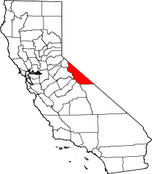 | |
| CDPs | ||
| Unincorporated communities | ||
| Indian reservations | ||
| Former settlements | ||