Fountain County, Indiana
| Fountain County, Indiana | |
|---|---|
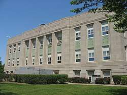 Fountain County Courthouse | |
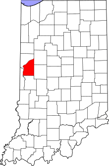 Location in the U.S. state of Indiana | |
 Indiana's location in the U.S. | |
| Founded | 1 April 1826 |
| Named for | James Fontaine |
| Seat | Covington |
| Largest city | Attica |
| Area | |
| • Total | 397.88 sq mi (1,031 km2) |
| • Land | 395.66 sq mi (1,025 km2) |
| • Water | 2.22 sq mi (6 km2), 0.56% |
| Population | |
| • (2010) | 17,240 |
| • Density | 44/sq mi (16.82/km2) |
| Congressional district | 4th |
| Time zone | Eastern: UTC−5/−4 |
|
Footnotes: Indiana county number 23 FIPS code 045[1] | |
Fountain County lies in the western part of the U.S. state of Indiana on the east side of the Wabash River. he county was officially established in 1826 and was the 53rd in Indiana. The county seat is Covington.[2]
According to the 2000 census, its population was 17,954;[3] the 2010 population was 17,240.[1] The county has two incorporated cities and six incorporated towns with a total population of about 9,700, as well as many small unincorporated communities. It is divided into eleven townships which provide local services.[4][5] An interstate highway, two U.S. Routes and five Indiana state roads cross the county, as does a major railroad line.[6][7]
History
The state of Indiana was established in 1816. The first non-indigenous settler in the future Fountain County is thought to have been a Mr. Forbes, who arrived here in early 1823 and was soon followed by others.[8] The legislative act creating Fountain County was passed on 30 December 1825, setting an effective date of 1 April 1826. The county's boundaries have remained unchanged since that time.[9] It was named for Major James Fontaine of Kentucky who was killed at Harmar's Defeat (near modern Fort Wayne, Indiana) on 22 October 1790, during the Northwest Indian War.[10][11]
The first Fountain County courthouse was a two-story frame building constructed in Covington in 1827; Abraham Griffith submitted the winning bid of $335.[n 1] In 1829, plans were made for a larger courhouse building, but then an act of the legislature called for the county seat to be moved. In the end it was decided that the county seat should remain in Covington, and the brick courthouse was completed in 1833. A third courthouse was commissioned in 1856, and was completed in 1857 at a cost of $33,500.[n 2] The circuit court met for the first time in the new building in January 1860, and the building was largely destroyed by fire the same day. Isaac Hodgson was the architect for the rebuilt courthouse, which was first occupied in January 1861; the total cost, including the reconstruction, totaled $54,624.05.[n 3][13] The current courthouse was built in 1936–37 at a cost of $246,734;[n 4] it replaced the previous building which had been declared unsafe. The 1937 building was constructed by the Jacobson Brothers of Chicago; the architects were Louis R. Johnson and Walter Scholar of Lafayette. The courthouse walls display murals painted by Eugene Francis Savage and others from 1937 to 1940, covering 2,500 square feet (232 m2) of wall space and depicting the settlement of western Indiana.[14]
Digging on the Wabash and Erie Canal began in 1832 and worked southwest; it reached Lafayette by 1842. In 1846 it reached Covington, and by 1847 traffic was moving through the county via the canal. Completion of the county's first railroad line in the 1850s heralded an end to the canal's usefulness, and in 1875 the last canal boat passed through Covington.[15]
The first railway line through the county was the Toledo, Wabash and Western Railway (later the Wabash Railroad) which was built from the east across the northern part of the county and reached Attica in 1856; it continued west through Warren County and reached the Illinois state line the following year. The Indianapolis, Crawfordsville and Danville Railroad (later the Indiana, Bloomington and Western Railway), was started in 1855, but the general state of the economy halted construction in 1858. It was completed by another owner in 1870, and traffic started in 1871. It passed through Covington, Veedersburg and Hillsboro.[16]
Geography
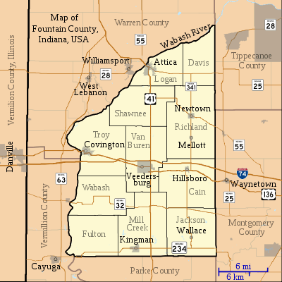
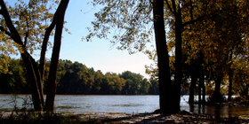
Fountain County's northern and western borders are defined by the Wabash River which flows out of Tippecanoe County to the northeast.
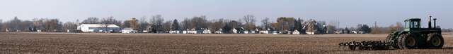
According to the 2010 census, the county has a total area of 397.88 square miles (1,030.5 km2), of which 395.66 square miles (1,024.8 km2) (or 99.44%) is land and 2.22 square miles (5.7 km2) (or 0.56%) is water.[17] Elevations range from 770 feet (230 m) above sea level in the northeastern part of the county to 465 feet (142 m) in the southwest where the Wabash River leaves the county. The county is within the drainage basin of the Wabash River, sloping to the southwest. It is covered with loess ranging in thickness from a few inches to more than 7 feet (2.1 m). Approximately 84 percent of the county's land is use for agriculture.[18]
The Portland Arch Nature Preserve and the Miller-Campbell Memorial Tract, a 435-acre (176 ha) preserve managed by the Indiana Department of Natural Resources, are located adjacent to the Wabash River.[19]
Adjacent counties
- Warren County (northwest)
- Vermillion County (southwest)
- Parke County (south)
- Montgomery County (east).
Communities
Cities
Incorporated towns
Unincorporated communities
Previous settlements
- Stringtown - an abandoned mining settlement south of Covington
There are several coal mines in southwest Fountain County.[21]
Townships
Transportation
Highways
Interstate 74 runs east–west through the middle of Fountain County.[23] US Route 136 follows the same general east–west route of I-74 through the county; in the eastern part it runs on the south side of the interstate, but crosses to the north side between Veedersburg and Covington.[24] US Route 41 runs north–south through the county, passing through Attica and Veedersburg.[25]
Three east–west state roads cross the county. State Road 28 enters Attica from Warren County and crosses the north end of the county.[26] State Road 32 enters the middle of the county from Perrysville to the west and passes through Fountain County on its way to Crawfordsville to the east.[27] State Road 234, further to the south, enters from Cayuga to the west and passes east through Kingman.[28] Two north–south state roads run through the county. State Road 55 passes through Attica and shares the route of US Route 41 running goes south. At Rob Roy it turns to run southeast through Newton.[29] State Road 341 starts at State Road 28 in the north and runs south, ending at State Road 234.[30]
Railroads
A Norfolk Southern Railway line crosses northern Fountain County on its route between Danville, Illinois and Lafayette, Indiana;[7] it carries about 45 freight trains each day.[31]
Air transportation
Purdue University Airport is Indiana's second busiest airport. It is in Tippecanoe County, operated by Purdue University.[32]
Indianapolis International Airport is located about 70 miles (110 km) east of Fountain County.[33]
Climate and weather
| Covington, Indiana | ||||||||||||||||||||||||||||||||||||||||||||||||||||||||||||
|---|---|---|---|---|---|---|---|---|---|---|---|---|---|---|---|---|---|---|---|---|---|---|---|---|---|---|---|---|---|---|---|---|---|---|---|---|---|---|---|---|---|---|---|---|---|---|---|---|---|---|---|---|---|---|---|---|---|---|---|---|
| Climate chart (explanation) | ||||||||||||||||||||||||||||||||||||||||||||||||||||||||||||
| ||||||||||||||||||||||||||||||||||||||||||||||||||||||||||||
| ||||||||||||||||||||||||||||||||||||||||||||||||||||||||||||
Fountain County is in the humid continental climate region of the United States along with most of Indiana. Its Köppen climate classification is Dfa,[35] meaning that it is cold, has no dry season, and has a hot summer.[36] In recent years, average temperatures in the county seat of Covington have ranged from a low of 15 °F (−9 °C) in January to a high of 85 °F (29 °C) in July, although a record low of −26 °F (−32 °C) was recorded in January 1994 and a record high of 105 °F (41 °C) was recorded in August 1988. Average monthly precipitation ranged from 1.80 inches (46 mm) inches in February to 4.53 inches (115 mm) inches in June.[34]
From 1950 through 2009, six tornadoes were reported in Fountain County, causing $25 million in damage but no fatalities.[37]
Education
Three public bodies administer Fountain County schools:
- Attica Consolidated School Corporation (northern Fountain County) – served 964 students during the 2009–2010 school year. It runs Attica Elementary and Attica Junior–Senior High Schools.
- Covington Community School Corporation (western Fountain County) – served 1,012 students during 2009–2010. It runs Covington Elementary, Covington Middle, and Covington High Schools.
- Southeast Fountain School Corporation (eastern Fountain County) – served 1,279 students during 2009–2010. It runs Southeast Fountain Elementary and Fountain Central Junior–Senior High Schools.[38]
Notable people
Daniel Wolsey Voorhees was born in Ohio but was raised in Fountain County. He attended school in Veedersburg, graduated from college in 1849, was admitted to the bar, and began practicing law in Covington; he moved to Terre Haute in 1857. He served as a United States Senator (1877–1897), and was known as "the tall sycamore of the Wabash". He died in Washington in 1897 and is buried in Terre Haute.[39]
John Myers was born in Covington in 1927. He graduated from Covington High School, then from Indiana State University in Terre Haute; he served in the United States Army and then served in the US House of Representatives 1967–1997.[40]
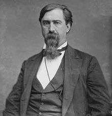 Daniel Voorhees
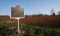 Voorhees historical marker
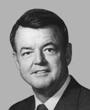 John Myers
Government
The county government is a constitutional body granted specific powers by the Constitution of Indiana and the Indiana Code. The county council is the legislative branch of the county government and controls all spending and revenue collection. Representatives are elected from county districts. The council members serve four-year terms and are responsible for setting salaries, the annual budget and special spending. The council also has limited authority to impose local taxes, in the form of an income and property tax that is subject to state level approval, excise taxes and service taxes.[41][42] In 2010, the county budgeted approximately $9.8 million for the district's schools and $3.2 million for other county operations and services, for a total annual budget of approximately $13 million.[43]
A board of commissionsers comprises the county's executive body. The commissioners are elected county-wide, in staggered four–year terms. One commissioner serves as president. The commissioners are charged with executing the acts legislated by the council, collecting revenue and managing day-to-day functions of the county government.[41][42]
The county maintains a circuit court. The judge on the court is elected to a term of six years and must be a lawyer admitted to practice law in Indiana.[42]
The county has other elected offices, including sheriff, coroner, auditor, treasurer, recorder, and circuit court clerk. Each of these elected officers serves a term of four years and oversees a different part of county government. Members elected to county government positions are required to declare party affiliations and be residents of the county.[42]
Each township has a trustee who administers rural fire protection and ambulance service, provides poor relief and manages cemetery care, among other duties.[5] The trustee is assisted by a three-member township board. The trustees and board members are elected to four-year terms.[44]
Based on the 2000 census, Fountain County is part of Indiana's 4th congressional district and Indiana's 8th congressional district; Indiana Senate district 23;[45] and Indiana House of Representatives district 42.[46]
| Year | Republican | Democratic | Third parties |
|---|---|---|---|
| 2016 | 75.1% 5,662 | 19.6% 1,476 | 5.3% 397 |
| 2012 | 65.6% 4,664 | 31.5% 2,237 | 3.0% 210 |
| 2008 | 56.0% 4,158 | 41.7% 3,094 | 2.3% 174 |
| 2004 | 67.4% 5,260 | 31.7% 2,477 | 0.9% 67 |
| 2000 | 60.5% 4,408 | 37.3% 2,717 | 2.1% 156 |
| 1996 | 54.0% 3,984 | 31.6% 2,327 | 14.4% 1,063 |
| 1992 | 40.3% 3,391 | 33.6% 2,829 | 26.0% 2,190 |
| 1988 | 60.6% 5,113 | 38.9% 3,279 | 0.6% 49 |
| 1984 | 64.9% 5,450 | 34.5% 2,897 | 0.6% 50 |
| 1980 | 62.2% 5,289 | 33.5% 2,845 | 4.4% 372 |
| 1976 | 54.2% 4,903 | 45.2% 4,089 | 0.7% 60 |
| 1972 | 66.4% 5,979 | 33.1% 2,977 | 0.5% 47 |
| 1968 | 53.0% 5,110 | 33.6% 3,237 | 13.4% 1,290 |
| 1964 | 45.4% 4,666 | 54.2% 5,574 | 0.4% 38 |
| 1960 | 58.7% 6,123 | 41.0% 4,277 | 0.3% 29 |
| 1956 | 63.1% 6,456 | 36.7% 3,751 | 0.2% 23 |
| 1952 | 61.4% 6,208 | 38.3% 3,871 | 0.4% 40 |
| 1948 | 54.8% 5,186 | 44.5% 4,215 | 0.7% 70 |
| 1944 | 57.7% 5,557 | 41.8% 4,022 | 0.5% 46 |
| 1940 | 54.6% 5,771 | 45.2% 4,783 | 0.2% 18 |
| 1936 | 45.2% 4,663 | 54.5% 5,617 | 0.4% 36 |
| 1932 | 41.8% 4,162 | 56.9% 5,665 | 1.2% 123 |
| 1928 | 55.6% 4,960 | 43.7% 3,894 | 0.8% 67 |
| 1924 | 51.3% 4,796 | 45.8% 4,282 | 2.9% 275 |
| 1920 | 54.1% 5,218 | 42.4% 4,088 | 3.5% 341 |
| 1916 | 48.4% 2,634 | 44.7% 2,437 | 6.9% 376 |
| 1912 | 28.8% 1,560 | 46.2% 2,499 | 25.0% 1,351 |
| 1908 | 48.9% 2,894 | 48.1% 2,846 | 3.0% 178 |
| 1904 | 52.1% 3,060 | 43.6% 2,560 | 4.4% 256 |
| 1900 | 49.9% 3,015 | 48.0% 2,896 | 2.1% 127 |
| 1896 | 48.0% 2,809 | 51.2% 2,997 | 0.8% 47 |
| 1892 | 46.6% 2,379 | 45.7% 2,331 | 7.7% 395 |
| 1888 | 49.4% 2,608 | 47.8% 2,525 | 2.8% 145 |
Demographics
| Historical population | |||
|---|---|---|---|
| Census | Pop. | %± | |
| 1830 | 7,619 | — | |
| 1840 | 11,218 | 47.2% | |
| 1850 | 13,253 | 18.1% | |
| 1860 | 15,566 | 17.5% | |
| 1870 | 16,389 | 5.3% | |
| 1880 | 20,228 | 23.4% | |
| 1890 | 19,558 | −3.3% | |
| 1900 | 21,446 | 9.7% | |
| 1910 | 20,439 | −4.7% | |
| 1920 | 18,823 | −7.9% | |
| 1930 | 17,971 | −4.5% | |
| 1940 | 18,299 | 1.8% | |
| 1950 | 17,836 | −2.5% | |
| 1960 | 18,706 | 4.9% | |
| 1970 | 18,257 | −2.4% | |
| 1980 | 19,033 | 4.3% | |
| 1990 | 17,808 | −6.4% | |
| 2000 | 17,954 | 0.8% | |
| 2010 | 17,240 | −4.0% | |
| Est. 2016 | 16,486 | [48] | −4.4% |
| U.S. Decennial Census[49] 1790-1960[50] 1900-1990[51] 1990-2000[52] 2010-2013[1] | |||
As of the 2010 United States Census, there were 17,240 people, 6,935 households, and 4,787 families residing in the county.[53] The population density was 43.6 inhabitants per square mile (16.8/km2). There were 7,865 housing units at an average density of 19.9 per square mile (7.7/km2).[17] The racial makeup of the county was 97.5% white, 0.2% black or African American, 0.3% Native American, 0.2% Asian, 0.0% Pacific Islander, 0.8% from other races, and 1.0% from two or more races. Those of Hispanic or Latino origin made up 2.2% of the population.[53] In terms of ancestry, 21.6% were German, 14.4% were Irish, 14.3% were American, and 12.5% were English.[54]
Of the 6,935 households, 31.2% had children under the age of 18 living with them, 54.7% were married couples living together, 10.0% had a female householder with no husband present, 31.0% were non-families, and 26.7% of all households were made up of individuals. The average household size was 2.46 and the average family size was 2.95. The median age was 41.6 years.[53]
The median income for a household in the county was $47,697 and the median income for a family was $51,696. Males had a median income of $44,118 versus $28,462 for females. The per capita income for the county was $20,949. About 8.9% of families and 13.2% of the population were below the poverty line, including 18.8% of those under age 18 and 9.5% of those age 65 or over.[55]
See also
Notes
- ↑ A $335 capital expense in 1827 would be roughly equivalent to $200,000 in 2009.[12]
- ↑ A $33,500 capital expense in 1857 would be roughly equivalent to $10,900,000 in 2009.[12]
- ↑ A $54,624 capital expense in 1861 would be roughly equivalent to $17,600,000 in 2009.[12]
- ↑ A $246,734 capital expense in 1936 would be roughly equivalent to $17,300,000 in 2009.[12]
References
- 1 2 3 "Fountain County QuickFacts". United States Census Bureau. Archived from the original on 10 July 2011. Retrieved 17 July 2011.
- ↑ "Find a County – Fountain County IN". National Association of Counties. Archived from the original on 19 July 2011. Retrieved 6 January 2011.
- ↑ U.S. Census Bureau. Census 2000, Summary File 1. "GCT-PH1. Population, Housing Units, Area, and Density: 2000 - County -- Subdivision and Place". American FactFinder. <http://factfinder2.census.gov>. Retrieved 2008-01-31.
- ↑ "Fountain". Indiana Township Association. Retrieved 12 February 2011.
- 1 2 "Duties". United Township Association of Indiana. Retrieved 6 January 2011.
- ↑ "Indiana Transportation Map 2009–2010" (PDF). Indiana Department of Transportation. 2009. Retrieved 16 December 2010.
- 1 2 "State of Indiana 2011 Rail System Map" (PDF). Indiana Department of Transportation. 2011. Retrieved 19 June 2011.
- ↑ Clifton 1913, p. 47.
- ↑ Clifton 1913, pp. 57–59.
- ↑ Gannett, Henry (1905). The Origin of Certain Place Names in the United States. US Government Printing Office. p. 130.
- ↑ Goodrich, De Witt Clinton; Tuttle, Charles Richard (1875). An Illustrated History of the State of Indiana. Indianapolis: Richard S. Peale & Co. p. 557.
- 1 2 3 4 Williamson, Samuel H. (April 2010). Seven Ways to Compute the Relative Value of a U.S. Dollar Amount, 1774 to present. MeasuringWorth.
- ↑ Clifton 1913, pp. 64–67.
- ↑ Counts, Will; Jon Dilts (1991). The 92 Magnificent Indiana Courthouses. Bloomington IN: Indiana University Press. pp. 52, 53. ISBN 978-0-253-33638-5.
- ↑ Clifton 1913, pp. 130–131.
- ↑ Clifton 1913, pp. 131–132.
- 1 2 "Population, Housing Units, Area, and Density: 2010 - County". United States Census Bureau. Retrieved 10 July 2015.
- ↑ United States Department of Agriculture's Natural Resources Conservation Service (2003). Soil Survey of Fountain County IN (PDF) (Report). US Government Printing Office. Archived from the original (PDF) on 9 October 2010. Retrieved 14 February 2011.
- ↑ "Portland Arch Nature Preserve and the Miller-Campbell Memorial Tract" (PDF). Indiana Department of Natural Resources. Archived from the original (PDF) on 19 November 2011. Retrieved 2 January 2012.
- ↑ United States Geological Survey. "Geographic Names Information System: Populated places in Fountain County, Indiana". Retrieved 15 February 2010.
- ↑ "Map Showing Surface Coal Mines in Fountain County, Indiana" (PDF). Indiana Geological Survey. Archived from the original (PDF) on 25 April 2012. Retrieved 22 October 2011.
- ↑ Clifton 1913, p. 59.
- ↑ "Interstate 74". Highway Explorer. Archived from the original on 11 July 2011. Retrieved 21 September 2010.
- ↑ "US Route 136". Highway Explorer. Archived from the original on 11 July 2011. Retrieved 21 September 2010.
- ↑ "US Route 41". Highway Explorer. Archived from the original on 7 December 2010. Retrieved 21 September 2010.
- ↑ "State Road 28". Highway Explorer. Archived from the original on 11 July 2011. Retrieved 21 September 2010.
- ↑ "State Road 32". Highway Explorer. Archived from the original on 11 July 2011. Retrieved 21 September 2010.
- ↑ "State Road 234". Highway Explorer. Archived from the original on 11 July 2011. Retrieved 21 September 2010.
- ↑ "State Road 55". Highway Explorer. Archived from the original on 11 July 2011. Retrieved 21 September 2010.
- ↑ "State Road 341". Highway Explorer. Archived from the original on 11 July 2011. Retrieved 21 September 2010.
- ↑ Warren County Local Economic Development Organization. "Warren County Transportation/Utilities". Retrieved 12 September 2010.
- ↑ "Airport Information". Purdue University. Archived from the original on 3 February 2011. Retrieved 8 February 2011.
- ↑ "Indiana Public Use Airports". Indiana Department of Transportation. Retrieved 1 February 2011.
- 1 2 "Monthly Averages for Covington IN". The Weather Channel. Retrieved 27 January 2011.
- ↑ "Köppen Climate Classification for the Conterminous United States". Idaho State Climate Services. Archived from the original on 21 January 2011. Retrieved 23 January 2011.
- ↑ Peel, M. C.; Finlayson, B. L.; McMahon, T. A. (2007). "Updated world map of the Köppen-Geiger climate classification" (PDF). Copernicus Publications. p. 1636. Retrieved 23 January 2011.
- ↑ "Fountain County Tornadoes, 1950–2009". National Weather Service. Retrieved 20 October 2011.
- ↑ "Fountain County Public Schools". Indiana Department of Education. Retrieved 12 February 2011.
- ↑ "Biographical Directory of the United States Congress: Voorhees, Daniel Wolsey". United States Congress. Retrieved 12 February 2011.
- ↑ "Biographical Directory of the United States Congress: Myers, John Thomas". United States Congress. Retrieved 12 February 2011.
- 1 2 Indiana Code. "Title 36, Article 2, Section 3". Government of Indiana. Retrieved 16 September 2008.
- 1 2 3 4 Indiana Code. "Title 2, Article 10, Section 2" (PDF). Government of Indiana. Retrieved 16 September 2008.
- ↑ State of Indiana Department of Local Government Finance. "2010 Budget Order (Fountain County IN)" (PDF). Retrieved 12 February 2011.
- ↑ "Government". United Township Association of Indiana. Retrieved 6 January 2011.
- ↑ "Indiana Senate Districts". State of Indiana. Retrieved 23 January 2011.
- ↑ "Indiana House Districts". State of Indiana. Retrieved 23 January 2011.
- ↑ Leip, David. "Dave Leip's Atlas of U.S. Presidential Elections". uselectionatlas.org. Retrieved 10 April 2018.
- ↑ "Population and Housing Unit Estimates". Retrieved 9 June 2017.
- ↑ "U.S. Decennial Census". United States Census Bureau. Archived from the original on 12 May 2015. Retrieved 10 July 2014.
- ↑ "Historical Census Browser". University of Virginia Library. Retrieved 10 July 2014.
- ↑ "Population of Counties by Decennial Census: 1900 to 1990". United States Census Bureau. Retrieved 10 July 2014.
- ↑ "Census 2000 PHC-T-4. Ranking Tables for Counties: 1990 and 2000" (PDF). United States Census Bureau. Retrieved 10 July 2014.
- 1 2 3 "Profile of General Population and Housing Characteristics: 2010 Demographic Profile Data". United States Census Bureau. Retrieved 10 July 2015.
- ↑ "Selected Social Characteristics in the United States – 2006-2010 American Community Survey 5-Year Estimates". United States Census Bureau. Retrieved 10 July 2015.
- ↑ "Selected Economic Characteristics – 2006-2010 American Community Survey 5-Year Estimates". United States Census Bureau. Retrieved 10 July 2015.
Bibliography
- Beckwith, H. W. (1881). History of Fountain County, together with historic notes on the Wabash Valley. Chicago: H. H. Hill and N. Iddings.
- Clifton, Thomas, ed. (1913). Past and Present of Fountain and Warren Counties Indiana. Indianapolis: BF Bowen & Co. pp. 25–200. Retrieved 19 September 2010.
External links
| Wikimedia Commons has media related to Fountain County, Indiana. |
- Fountain County official website
- Western Indiana Community Foundation
- Attica Consolidated School Corporation
- Covington Community School Corporation
- Southeast Fountain School Corporation
Places adjacent to Fountain County, Indiana | ||||||||||
|---|---|---|---|---|---|---|---|---|---|---|
| ||||||||||
Municipalities and communities of Fountain County, Indiana, United States | ||
|---|---|---|
| Cities | ||
| Towns | ||
| Townships | ||
| Unincorporated communities | ||
