Loess
Loess (US: /lɛs,
Loess is an aeolian sediment formed by the accumulation of wind-blown silt,[3] typically in the 20–50 micrometer size range, twenty percent or less clay and the balance equal parts sand and silt[4] that are loosely cemented by calcium carbonate. It is usually homogeneous and highly porous and is traversed by vertical capillaries that permit the sediment to fracture and form vertical bluffs.
The word loess, with connotations of origin by wind-deposited accumulation, came into English from German Löss, which can be traced back to Swiss German and is cognate with the English word loose and the German word los.[5] It was first applied to Rhine River valley loess about 1821.[6][7]
Properties

Loess is homogeneous, porous, friable, pale yellow or buff, slightly coherent, typically non-stratified and often calcareous. Loess grains are angular with little polishing or rounding and composed of crystals of quartz, feldspar, mica and other minerals. Loess can be described as a rich, dust-like soil.[8]
Loess deposits may become very thick, more than a hundred meters in areas of China and tens of meters in parts of the Midwestern United States. It generally occurs as a blanket deposit that covers areas of hundreds of square kilometers and tens of meters thick.
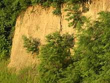
Loess often stands in either steep or vertical faces.[9] Because the grains are angular, loess will often stand in banks for many years without slumping. This soil has a characteristic called vertical cleavage which makes it easily excavated to form cave dwellings, a popular method of making human habitations in some parts of China. Loess will erode very readily.
In several areas of the world, loess ridges have formed that are aligned with the prevailing winds during the last glacial maximum. These are called "paha ridges" in America and "greda ridges" in Europe. The form of these loess dunes has been explained by a combination of wind and tundra conditions.
Etymology
Loess comes from the German Löss or Löß, and ultimately from Alemannic lösch meaning drop as named by peasants and masons along the Rhine Valley.
History of research
The term "Löß" was first described in Central Europe by Karl Cäsar von Leonhard (1823–1824)[10] who reported yellowish brown, silty deposits along the Rhine valley near Heidelberg.[1] Charles Lyell (1834) brought this term into widespread usage by observing similarities between loess and loess derivatives along the loess bluffs in the Rhine and Mississippi.[1] At that time it was thought that the yellowish brown silt-rich sediment was of fluvial origin being deposited by the large rivers.[1] It wasn't until the end of the 19th century that the aeolian origin of loess was recognized (Virlet D'Aoust 1857),[11] especially the convincing observations of loess in China by Ferdinand von Richthofen (1878).[1][12] A tremendous number of papers have been published since then, focusing on the formation of loess and on loess/palaeosol (older soil buried under deposits) sequences as archives of climate and environment change.[1] These water conservation works were carried out extensively in China and the research of Loess in China has been continued since 1954. (Liu TS, Loess and the environment)
Much effort was put into the setting up of regional and local loess stratigraphies and their correlation (Kukla 1970, 1975, 1977).[13][14][15] But even the chronostratigraphical position of the last interglacial soil correlating to marine isotope substage 5e has been a matter of debate, owing to the lack of robust and reliable numerical dating, as summarized for example in Zöller et al. (1994)[16] and Frechen, Horváth & Gábris (1997)[17] for the Austrian and Hungarian loess stratigraphy, respectively.[1]
Since the 1980s, thermoluminescence (TL), optically stimulated luminescence (OSL) and infrared stimulated luminescence (IRSL) dating are available providing the possibility for dating the time of loess (dust) deposition, i.e. the time elapsed since the last exposure of the mineral grains to daylight.[1] During the past decade, luminescence dating has significantly improved by new methodological improvements, especially the development of single aliquot regenerative (SAR) protocols (Murray & Wintle 2000)[18] resulting in reliable ages (or age estimates) with an accuracy of up to 5 and 10% for the last glacial record.[1] More recently, luminescence dating has also become a robust dating technique for penultimate and antepenultimate glacial loess (e.g. Thiel et al. 2011,[19] Schmidt et al. 2011)[20] allowing for a reliable correlation of loess/palaeosol sequences for at least the last two interglacial/glacial cycles throughout Europe and the Northern Hemisphere (Frechen 2011).[1][21] Furthermore, the numerical dating provides the basis for quantitative loess research applying more sophisticated methods to determine and understand high-resolution proxy data, such as the palaeodust content of the atmosphere, variations of the atmospheric circulation patterns and wind systems, palaeoprecipitation and palaeotemperature.[1]
Formation
According to Pye (1995),[22] four fundamental requirements are necessary for the formation of loess: a dust source, adequate wind energy to transport the dust, a suitable accumulation area, and a sufficient amount of time.[1]
Periglacial loess
Periglacial (glacial) loess is derived from the floodplains of glacial braided rivers that carried large volumes of glacial meltwater and sediments from the annual melting of continental icesheets and mountain icecaps during the spring and summer. During the autumn and winter, when melting of the icesheets and icecaps ceased, the flow of meltwater down these rivers either ceased or was greatly reduced. As a consequence, large parts of the formerly submerged and unvegetated floodplains of these braided rivers dried out and were exposed to the wind. Because these floodplains consist of sediment containing a high content of glacially ground flour-like silt and clay, they were highly susceptible to winnowing of their silts and clays by the wind. Once entrained by the wind, particles were then deposited downwind. The loess deposits found along both sides of the Mississippi River Alluvial Valley are a classic example of periglacial loess.[23][24]
During the Quaternary, loess and loess-like sediments were formed in periglacial environments on mid-continental shield areas in Europe and Siberia, on the margins of high mountain ranges like in Tajikistan and on semi-arid margins of some lowland deserts like in China.[1]
In England, periglacial loess is also known as brickearth.
Non-glacial
Non-glacial loess can originate from deserts, dune fields, playa lakes, and volcanic ash.
Some types of nonglacial loess are:[25]
- Desert loess produced by aeolian attrition of quartz grains [26]
- Volcanic loess in Ecuador and Argentina;
- Tropical loess in Argentina, Brazil and Uruguay;
- Gypsum loess in Spain;
- Trade wind loess in Venezuela and Brazil;
- Anticyclonic loess in Argentina.
The thick Chinese loess deposits are non-glacial loess having been blown in from deserts in northern China.[27] The loess covering the Great Plains of Nebraska, Kansas, and Colorado is considered to be non-glacial desert loess.[23] Non-glacial desert loess is also found in Australia[28] and Africa.[24]
Fertility
Loess tends to develop into very rich soils. Under appropriate climatic conditions, it is some of the most agriculturally productive terrain in the world.[29]
Soils underlain by loess tend to be excessively drained. The fine grains weather rapidly due to their large surface area, making soils derived from loess rich. One theory states that the fertility of loess soils is due largely to cation exchange capacity (the ability of plants to absorb nutrients from the soil) and porosity (the air-filled space in the soil). The fertility of loess is not due to organic matter content, which tends to be rather low, unlike tropical soils which derive their fertility almost wholly from organic matter.
Even well managed loess farmland can experience dramatic erosion of well over 2.5 kg /m2 per year. In China the loess deposits which give the Yellow River its color have been farmed and have produced phenomenal yields for over one thousand years. Winds pick up loess particles, contributing to the Asian Dust pollution problem. The largest deposit of loess in the United States, the Loess Hills along the border of Iowa and Nebraska, has survived intensive farming and poor farming practices. For almost 150 years, this loess deposit was farmed with mouldboard ploughs and fall tilled, both intensely erosive. At times it suffered erosion rates of over 10 kilograms per square meter per year. Today this loess deposit is worked as low till or no till in all areas and is aggressively terraced.
Large areas of loess deposits and soils
Argentina

Much of Argentina is covered by loess. Two areas of loess are usually distinguished in Argentina: the neotropical loess north of latitude 30° S and the pampean loess.[30]
The neotropical loess is made of silt or silty clay. Relative to the pampean loess the neotropical loess is poor in quartz and calcium carbonate. The source region for this loess is thought by some scientists to be areas of fluvio-glacial depostis the Andean foothills formed by the Patagonian Ice Sheet. Other researchers stress the importance of volcanic material in the neotropical loess.[30]
The pampean loess is sandy or made of silty sand.[30]
Central Asia
From Southern Tajikistan up to Almaty, Kazakhstan, spans an area of multiple loess deposits.[31]
China
The Loess Plateau (simplified Chinese: 黄土高原; traditional Chinese: 黃土高原; pinyin: huángtǔ gāoyuán), also known as the Huangtu Plateau, is a plateau that covers an area of some 640,000 km² in the upper and middle of China's Yellow River and China proper. The Yellow River was so named because the loess forming its banks gave a yellowish tint to the water.[32] The soil of this region has been called the "most highly erodible soil on earth".[33] The Loess Plateau and its dusty soil cover almost all of Shanxi, Shaanxi, and Gansu provinces, the Ningxia Hui Autonomous Region, and parts of others.
New Zealand
Extensive areas of loess occur in New Zealand.[34] The basis of loess stratigraphy was introduced by John Hardcastle in 1890 [35]
United States

The Loess Hills of Iowa owe their fertility to the prairie topsoils built by 10,000 years of post-glacial accumulation of organic-rich humus as a consequence of a persistent grassland biome. When the valuable A-horizon topsoil is eroded or degraded, the underlying loess soil is infertile, and requires the addition of fertilizer in order to support agriculture.
The loess along the Mississippi River near Vicksburg, Mississippi, consist of three layers. The Peoria Loess, Sicily Island Loess, and Crowley's Ridge Loess accumulated at different periods of time during the Pleistocene. Ancient soils, called paleosols, have developed in the top of the Sicily Island Loess and Crowley's Ridge Loess. The lowermost loess, the Crowley's Ridge Loess, accumulated during the late Illinoian Stage. The middle loess, Sicily Island Loess, accumulated during early Wisconsin Stage. The uppermost loess, the Peoria Loess, in which the modern soil has developed, accumulated during the late Wisconsin Stage. Animal remains include terrestrial gastropods and mastodons.[37]
See also
References
This article incorporates CC-BY-3.0 text from the reference[1]
- 1 2 3 4 5 6 7 8 9 10 11 12 13 14 Frechen, M (2011). "Loess in Europe". Quaternary Science Journal. 60 (1): 3–5. doi:10.3285/eg.60.1.00.
- ↑ Vasiljevic, D. A.; Markovic, S. B.; Hose, T. A.; Smalley, I.; O'Hara-Dhand, K.; Basarin, B.; Lukic, T.; Vujicic, M. D. (2011). "Loess Towards (Geo) Tourism – Proposed Application on Loess in Vojvodina Region (North Serbia)". Acta geographica Slovenica. 51 (2): 390–406. doi:10.3986/AGS51305.
- ↑ Smalley, I.J., Derbyshire, E. 1990. The definition of 'ice-sheet' and 'mountain' loess. Area 22, 300-301
- ↑ Donahue, Miller, Shickluna (1977). Soils: An Introduction to Soils and Plant Growth, 4th edition. Prentice Hall
- ↑ "loess - Origin and meaning of loess by Online Etymology Dictionary". www.etymonline.com.
- ↑ "loess (sedimentary deposit) - Encyclopædia Britannica". Britannica.com. Retrieved 2013-12-22.
- ↑ "DWDS | Suchergebnisse". Dwds.de. Retrieved 2013-12-22.
- ↑ Pearson Prentice Hall - World Studies - Europe and Russia
- ↑ Neuendorf, K.E.K., J.P. Mehl Jr., and J.A. Jackson, 2005, Glossary of Geology. Springer-Verlag, New York City, 779 pp., ISBN 3-540-27951-2
- ↑ Leonhard K. C. von (1823–1824). Charakteristik der Felsarten. 3 Vols., J. Engelmann Verlag Heidelberg, pp. 772.
- ↑ Virlet D'Aoust P.T. (1857). "Observations sur un terrain d`origine météorique ou de transport aerien qui existe au Mexique et sur le phénomène des trombes de poussière auquel il doit principalement son origine". Geol. Soc. France, Full., 2d, Ser. 2, 129–139.
- ↑ Richthofen F. von (1878). "Bemerkungen zur Lößbildung". Verh Geol Reichsanst, Berlin, pp 1–13.
- ↑ Kukla G. (1970). "Correlation between loesses and deep-sea sediments". Geologiske Foreningen Foerhandlingar 92: 148–180. Stockholm.
- ↑ Kukla G. J. (1975). "Loess stratigraphy of Central Europe". In: Butzer K. W. & Isaac G. L. (eds.) After the Australopithecus, pp. 99–188. Mouton, The Hague.
- ↑ Kukla, G. J. (1977). "Pleistocene Land-Sea Correlations I. Europe". Earth-Science Reviews. 13: 307–374. Bibcode:1977ESRv...13..307K. doi:10.1016/0012-8252(77)90125-8.
- ↑ Zöller, L.; Oches, E. A.; McCoy, W. D. (1994). "Towards a revised chronostratigraphy of loess in Austria with respect to key sections in the Czech Republic and in Hungary". Quaternary Geochronology. 13: 465–472. Bibcode:1994QSRv...13..465Z. doi:10.1016/0277-3791(94)90059-0.
- ↑ Frechen, M.; Horváth, E.; Gábris, G. (1997). "Geochronology of Middle and Upper Pleistocene loess sections in Hungary". Quaternary Research. 48: 291–312. Bibcode:1997QuRes..48..291F. doi:10.1006/qres.1997.1929.
- ↑ Murray, A. S.; Wintle, A. G. (2000). "Luminescence dating of quartz using an improved single aliquot regenerative-dose protocol". Radiation Measurements. 32: 57–73. Bibcode:2000RadM...32...57M. doi:10.1016/S1350-4487(99)00253-X.
- ↑ Thiel, C.; Buylaert, J. P.; Murray, A. S.; Terhorst, B.; Tsukamoto, S.; Frechen, M.; Sprafke, T. (2011). "Investigating the chronostratigraphy of prominent palaeosols in Lower Austria using post-IR IRSL dating". Quaternary Science Journal. 60 (1): 137–152. doi:10.3285/eg.60.1.10.
- ↑ Schmidt, E. D.; Semmel, A.; Frechen, M. (2011). "Luminescence dating of the loess/palaeosol sequence at the gravel quarry Gaul/Weilbach, Southern Hesse (Germany)"". Quaternary Science Journal. 60 (1): 116–125. doi:10.3285/eg.60.1.08.
- ↑ Frechen, M. (2011). "Loess in Eurasia". Quaternary International. 234 (1–2): 1–3. Bibcode:2011QuInt.234....1F. doi:10.1016/j.quaint.2010.11.014.
- ↑ Pye, K (1995). "The nature, origin and accumulation of loess". Quaternary Science Reviews. 14: 653–667. Bibcode:1995QSRv...14..653P. doi:10.1016/0277-3791(95)00047-x.
- 1 2 Bettis, E.A.; Muhs, D.R.; Roberts, H.M.; Wintle, A.G. (2003). "Last Glacial loess in the conterminous USA". Quaternary Science Reviews. 22 (18–19): 1907–1946. Bibcode:2003QSRv...22.1907A. doi:10.1016/S0277-3791(03)00169-0.
- 1 2 Muhs, D.R.; Bettis, III, E.A. (2003). "Quaternary loess-paleosol sequences as examples of climate-driven sedimentary extremes" (PDF). GSA Special Papers. 370: 53–74. doi:10.1130/0-8137-2370-1.53.
- ↑ Iriondo, M.H.; Krohling, D.M. (2007). "Non-classical types of loess". Sedimentary Geology. 202 (3): 352–368. Bibcode:2007SedG..202..352I. doi:10.1016/j.sedgeo.2007.03.012.
- ↑ Whalley, W.B., Marshall, J.R., Smith, B.J. 1982, Origin of desert loess from some experimental observations, Nature, 300, 433-435.
- ↑ Ding, Z.; Sun, J. (1999). "Changes in Sand Content of Loess Deposits along a North–South Transect of the Chinese Loess Plateau and the Implications for Desert Variations". Quaternary Research. 52: 56–62. Bibcode:1999QuRes..52...56D. doi:10.1006/qres.1999.2045.
- ↑ Haberlah, D (2007). "A call for Australian loess". AREA. 39 (2): 224–229. doi:10.1111/j.1475-4762.2007.00730.x.
- ↑ Getis, Arthur; Judith Getis and Jerome D. Fellmann (2000). Introduction to Geography, Seventh Edition. McGraw Hill. p. 99. ISBN 0-697-38506-X.
- 1 2 3 Sagayo, José Manuel (1995). "The Argentine neotropical loess: An overview". Quaternary Science Reviews. Pergamon. 14 (7–8): 755–766. Bibcode:1995QSRv...14..755S. doi:10.1016/0277-3791(95)00050-X.
- ↑ Ding, Z.L. (2002). "The loess record in southern Tajikistan and correlation with Chinese loess". Earth and Planetary Science Letters. Elsevier. 200 (3–4): 387–400. Bibcode:2002E&PSL.200..387D. doi:10.1016/S0012-821X(02)00637-4. , Fig. 1 (b) showing the distribution of loess, deserts, and mountains in Central Asia (adopted from [T.S. Liu, Loess and the Environment, China Ocean Press, Beijing, 1985.]). The locality of the Chashmanigar loess section is indicated by the solid arrow.
- ↑ "Huang He". The Columbia Encyclopedia (6th ed.). 2007. Archived from the original on June 5, 2009.
- ↑ John M. Laflen, Soil Erosion and Dryland Farming, 2000, CRC Press, 736 pages ISBN 0-8493-2349-5
- ↑ Smalley, I.J., Davin, J.E. 1980. The First Hundred Years-A Historical Bibliography of New Zealand Loess. New Zealand Soil Bureau Bibliographic Report 28, 166pp.
- ↑
- Hardcastle, J. 1890. On the Timaru loess as a climate register. Transcations & Proceedings of the New Zealand Institute 23, 324-332 (on line: Royal Society of New Zealand http://rsnz.natlib.govt.nz; reproduced in Loess Letter supplement 23, November 1988).
- ↑ Muhs; et al. (2013-02-06). "Eolian History of North America: Task 2, Understand the paleoclimatic significance of loess". USGS. Archived from the original on 2013-02-18.
- ↑ Miller, B.J., G.C. Lewis, J.J. Alford, and W.J. Day, 1985, Loesses in Louisiana and at Vicksburg, Mississippi. Guidebook, Friends of the Pleistocene Field Trip, 12-14 April, 1985. LA Agricultural Experimental Station, Louisiana State University, Baton Rouge, Louisiana. 126 pp.
Further reading
- Smalley, I.J.(editor) 1975. Loess Lithology & Genesis (Benchmark Geology 26) Dowden, Hutchinson & Ross 454pp.
- Smalley, I.J. 1980. Loess- A Partial Bibliography, Geobooks/Elsevier 103pp. ISBN 0 86094 036 5.
- Rozycki, S.Z. 1991. Loess and Loess-like Deposits. Ossolineum Wroclaw 187p. ISBN 83-04-03745-9
External links
| Look up loess in Wiktionary, the free dictionary. |
| Wikimedia Commons has media related to Loess. |
| Wikisource has the text of the 1920 Encyclopedia Americana article Loess. |
- 2006, The Secret of China’s Vast Loess Plateau Suburban Emergency Management Project, Chicago, Illinois.
- 2007, New European Loess Map. Helmholtz Centre for Environmental Research, Leipzig, Germany.
- Glacial Deposits: Loess and Till. Illinois State Museum, Springfield, Illinois.
- Briedis. C.A., 2006, Loess Thickness Map (of Illinois). Illinois State Geological Survey, Champaign, Illinois.
- The Bibliography of Aeolian Research
- Heinrich, P.V., 2008, Loess map of Louisiana., Public Information Series. no. 12, Louisiana Geological Survey, Baton Rouge, Louisiana.
- Prior, J.C., and D.J. Quade, nd, The Loess Hills: A Geologic View. Iowa Geological Survey, Department of Natural Resources, Iowa City, Iowa.
- U.S. Geological Survey, 1999, Geology of the Loess Hills, Iowa
- U.S. Geological Survey, 2006, Eolian History of North America Why is loess important to study?
- The Loess Hills of Western Iowa
- The Loess Hills of Roztocze