Coulonges-sur-l'Autize
| Coulonges-sur-l'Autize | |
|---|---|
| Commune | |
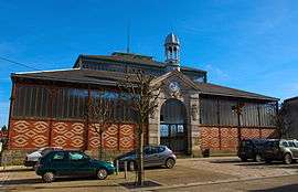 The covered market | |
 Coulonges-sur-l'Autize Location within Nouvelle-Aquitaine region  Coulonges-sur-l'Autize | |
| Coordinates: 46°29′03″N 0°35′52″W / 46.4842°N 0.5978°WCoordinates: 46°29′03″N 0°35′52″W / 46.4842°N 0.5978°W | |
| Country | France |
| Region | Nouvelle-Aquitaine |
| Department | Deux-Sèvres |
| Arrondissement | Niort |
| Canton | Autize-Égray |
| Government | |
| • Mayor (2008–2014) | Christian Bonnet |
| Area1 | 18.87 km2 (7.29 sq mi) |
| Population (2006)2 | 2,366 |
| • Density | 130/km2 (320/sq mi) |
| Time zone | UTC+1 (CET) |
| • Summer (DST) | UTC+2 (CEST) |
| INSEE/Postal code | 79101 /79160 |
| Elevation |
27–121 m (89–397 ft) (avg. 83 m or 272 ft) |
|
1 French Land Register data, which excludes lakes, ponds, glaciers > 1 km2 (0.386 sq mi or 247 acres) and river estuaries. 2 Population without double counting: residents of multiple communes (e.g., students and military personnel) only counted once. | |
Coulonges-sur-l'Autize is a commune in the Deux-Sèvres department in the Nouvelle-Aquitaine region in western France.
See also
References
| Wikimedia Commons has media related to Coulonges-sur-l'Autize. |
This article is issued from
Wikipedia.
The text is licensed under Creative Commons - Attribution - Sharealike.
Additional terms may apply for the media files.