Calvert Historic District
|
Calvert Historic District | |
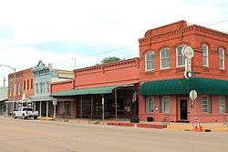
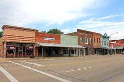 Calvert Historic District in 2013 | |
 Calvert Historic District  Calvert Historic District | |
| Location | Roughly bounded by Main, Garritt, Pin Oak, Maple, and Barton Sts., Calvert, Texas |
|---|---|
| Coordinates | 30°58′48″N 96°40′16″W / 30.98000°N 96.67111°WCoordinates: 30°58′48″N 96°40′16″W / 30.98000°N 96.67111°W |
| Area | 70 acres (28 ha) |
| Architect | Multiple; Unknown |
| Architectural style | Colonial Revival, Late Victorian, Queen Anne |
| NRHP reference # | 78002978[1] |
| Added to NRHP | April 3, 1978 |
The Calvert Historic District is a historic district which comprises 70 acres (280,000 m2) roughly bounded by Main, Garritt, Pin Oak, Maple, and Barton streets in Calvert, Texas. Contributing properties in the district consist of 82 buildings, one site and two other structures. On April 3, 1978, the district was added to the National Register of Historic Places.[1]
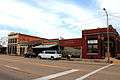
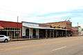
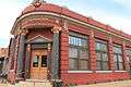
Photo gallery
See also
References
- 1 2 National Park Service (2010-07-09). "National Register Information System". National Register of Historic Places. National Park Service.
External links
![]()


This article is issued from
Wikipedia.
The text is licensed under Creative Commons - Attribution - Sharealike.
Additional terms may apply for the media files.