Barisal District
| Barisal District বরিশাল জেলা | |
|---|---|
| District | |
| Barishal District | |
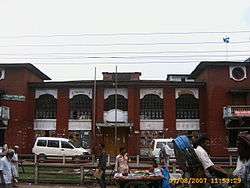 Barisal Town Hall | |
 Location of Barisal District in Bangladesh | |
| Coordinates: 22°48′N 90°22′E / 22.80°N 90.37°ECoordinates: 22°48′N 90°22′E / 22.80°N 90.37°E | |
| Country |
|
| Division | Barisal Division |
| Bakerganj District | 1760 |
| Area | |
| • Total | 2,784.52 km2 (1,075.11 sq mi) |
| Census 2011 | |
| Population (2011) | |
| • Total | 2,324,310 |
| • Density | 830/km2 (2,200/sq mi) |
| Demonym(s) | Barisali, Borishailla |
| Time zone | UTC+6 (BST) |
| Postal code | 8200 |
Barisal District, officially known as Barishal District,[1] is a district in south-central Bangladesh, formerly called Bakerganj district, established in 1797.[2] Its headquarters are in the city of Barisal, which is also the headquarters of Barisal Division.[3]
History
Barisal District is a district in southern Bangladesh and is also the headquarter of Barisal Division.[3] Barisal District traces its origins to Bakerganj district which was established in 1797. It was placed in Barisal Division on 1 January 1993.[2]
Demographics
Barisal District had a population of 2,324,310 at the 2011 Census (provisional).
Economy
Barisal's economic is mostly based on farming and fishing.
Transport
Barisal is served by the Barisal Airport which is located just outside the city. It has frequent flight services to Dhaka via Biman Bangladesh Airlines, Novo Air, US-Bangla Airlines, and GMG Airlines. There is a launch(ship),Green line water ways and bus for transport.
Education
Notable educational institutions in Barisal include Sher-e-Bangla Medical College, University of Barisal, Barisal Cadet College, Govt. B M College, Govt. Barisal College, Govt. Hatem Ali College, Govt. Woman's College, Barisal Polytechnic Institute, Govt. Fazlul Huq College, Barisal Technical School and College, A. Karim Ideal College, and Ideal Cadet School & College.
Subdivisions
Barisal District is divided into the following Upazilas (formerly called Thanas):
Culture and places of interest
The Bangabandhu Uddan (former Bell's Park) is a place inside Barisal City, right on the banks of the Kirtonkhola (or Kirton Khola) river. South of Barisal city there is a beach town, Kuakata. There are several hotels and motels in Kuakata. This is where the Marma live. Southeast, over the Kirtonkhola, Shahid Abdur Rab Serniabat Bridge was inaugurated in 2011.[4]
Notable personalities
- Mahapran Jogendra Nath Mandal, a Dalit and leader of the Namasudra community, was born here. He had fought throughout his political life against the upper caste Hindu overlings for the bare needs of the outcast and downtrodden, but sadly his nonesuch role in the history of the Subcontinent has been hidden by communal historians.
- A. K. Fazlul Huq politician, Chief Minister of undivided Bengal & Governor of erstwhile East Pakistan
- Mohiuddin Jahangir, officer in Sector 7 of the Muktibahini(1971).The highest recognition of bravery in Bangladesh, Bir Sreshtho.
- Abdul Gaffar Choudhury, journalist, who wrote Amar Bhaier Rokte Rangano to mark the Bengali Language Movement.
- Abdur Rahman Biswas, politician, President of Bangladesh
- Mahanambrata Brahmachari, Hindu saint
- Tofazzal Hossain Manik Miah, founder editor of The Daily Ittefaq
- Jibanananda Das, Bengali poet
- Kusumkumari Das, poet and mother of Jibanananda Das
- Aswini Kumar Dutta, founder of BM College
- Shamsuddin Abul Kalam, Bangladeshi novelist
- Sufia Kamal, poet of Bangladesh
- Altaf Mahmud, music director & lyrician, who composed Amar Bhaier Rokte Rangano
- Brajamohan Dutta, Bengali philanthropist and social worker
- Anil Biswas, music director composer of Bollywood.
- Kanai Chatterjee, Bengali maoist leader
- Hanif Sanket, Television host, writer, producer.
- Mithun Chakraborty, film actor, singer, producer, writer, social worker, entrepreneur, television presenter of Bollywood
References
| Wikimedia Commons has media related to Barisal District. |
- ↑ Mahadi Al Hasnat (2 April 2018). "Mixed reactions as govt changes English spellings of 5 district names". Dhaka Tribune. Retrieved 8 April 2018.
- 1 2 KAM Saiful Islam (2012). "Barisal District". In Sirajul Islam and Ahmed A. Jamal. Banglapedia: National Encyclopedia of Bangladesh (Second ed.). Asiatic Society of Bangladesh.
- 1 2 About Barisal Local Government Engineering Department, Local Government Division, Ministry of Local Government, Rural Development & Cooperatives; retrieved 14 May 2014.
- ↑ "PM pledges steps to check food prices". The Daily Star. UNB. Retrieved 3 October 2015.
| Barishal Division | 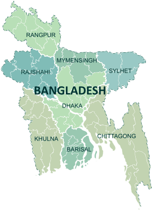 | |
|---|---|---|
| Chattagram Division | ||
| Dhaka Division | ||
| Khulna Division | ||
| Mymensingh Division | ||
| Rajshahi Division | ||
| Rangpur Division | ||
| Sylhet Division | ||