Jhenaidah District
| Jhenaidah ঝিনাইদহ | |
|---|---|
| District | |
| Nickname(s): Jhinaidoho, Jhineda | |
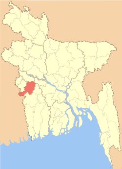 Location of Jhenaidah in Bangladesh | |
| Coordinates: 23°32′N 89°00′E / 23.54°N 89.00°ECoordinates: 23°32′N 89°00′E / 23.54°N 89.00°E | |
| Country |
|
| Division | Khulna Division |
| Area | |
| • Total | 1,964.77 km2 (758.60 sq mi) |
| Population (2011 census) | |
| • Total | 1,771,304 |
| • Density | 900/km2 (2,300/sq mi) |
| Time zone | UTC+6 (BST) |
Jhenaidah (Bengali: ঝিনাইদহ pron: dʒʱinaid̪ɔɦo) is a district in the southwestern part of Bangladesh. It is a part of the Khulna Division. It has an area of 1964.77 km².[1] It is bordered by the Kushtia District to the north, to the south by Jessore District and West Bengal (India), to the east by Rajbari District and Magura District and to the west by Chuadanga District and West Bengal (India) on the west.[2]
Geography
Annual average temperature: maximum 37.1 °C, minimum 11.2 °C; annual rainfall[3] 1467 mm
Demographics
Jhenaidah district has 1,771,304 people as of 2011.[1] Density of the population is 901.5 inh./km² [2011] – Change: +1.14%/year [2001 → 2011][4]
Administration
Deputy Commissioner (DC): Md. Zakir Hossain[5]
Chairman of Zila Porishod: Kanak Kanti Das
Mayor of Municipality: Saidul Karim Mintu[6]
Subdivisions
There are six upazilas under this district:
Education
- Jhenaidah Cadet College
- Jhenaidah Government Boys High School
- Jhenaidah Government Girls' High School
- Government K.C. College, Jhenaidah
- Jhenaidah Kanchannagar Model High School and College
- Jhenaidah IHT
- Jhenaidah Technical School and College (JTSC)
- Maheshpur High School (MHS)
- Maheshpur Girls' School (MGS)
- Maheshpur Government Degree College
- Maheshpur Municipal Women's College
- Govt. Naldanga Bhushan Pilot secondary School,(Kaliganj)
- Jhenaidah govt veterinary college
- Kotchandpur pailot secondary school
- Chandpara government primary school
- Jhenaidah Textile Engineering College
- Jhenaidah polytechnic institute
Religion
The district is predominately Muslim, 89.6%. The next largest religion is Hinduism with 10.3%.[2]
Notable residents
- Birshrestha Hamidur Rahman, National hero, a sepoy in Bangladesh Army during the Bangladesh Liberation War
- Abdul Hyee also known as Md.Abdul Hyee, a member of parliament, freedom fighter and commander during the Bangladesh Liberation War
- Jamal Nazrul Islam, a Bangladeshi mathematical physicist and cosmologist
See also
References
| Wikimedia Commons has media related to Jhenaidah District. |
- 1 2 "Jhenaidah (District (Zila))". Retrieved 2013-05-03.
- 1 2 BM Rezaul Karim (2012). "Jhenaidah District". In Sirajul Islam and Ahmed A. Jamal. Banglapedia: National Encyclopedia of Bangladesh (Second ed.). Asiatic Society of Bangladesh.
- ↑ http://wikimapia.org/24901555/Jhenaidah-Dist-Town
- ↑ http://www.citypopulation.de/php/bangladesh-admin.php?adm1id=44
- ↑ "মোঃ জাকির হোসেন" [Md. Zakir Hossain]. Jhenaidah District. Bangladesh National Portal.
- ↑ "জনপ্রতিনিধিদের তালিকা" [List of representatives]. Jhenaidah District. Bangladesh National Portal.
External links
| Upazila/Thana: | ||
|---|---|---|