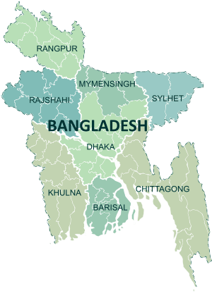
Rangpur District
| Rangpur রংপুর | |
|---|---|
| District | |
 Location of Rangpur in Bangladesh | |
| Coordinates: 25°44′N 89°15′E / 25.733°N 89.250°ECoordinates: 25°44′N 89°15′E / 25.733°N 89.250°E | |
| Country |
|
| Division | Rangpur Division |
| Government | |
| • Divisional Commissioner | Jashim Uddin Ahmed[1] |
| Area | |
| • Total | 2,370.45 km2 (915.24 sq mi) |
| Population (2011 census) | |
| • Total | 2,881,086 |
| • Density | 1,200/km2 (3,100/sq mi) |
| Demonym(s) | Rangpuri, Rongpuri |
| Time zone | UTC+6 (BST) |
| Postal code | 5400 |
| Website |
rangpur |
Rangpur (Bengali: রংপুর জেলা, Rongpur Jela also Rongpur Zilla) is a district in Northern Bangladesh. It is a part of the Rangpur Division.[2]
Geography
Under the Rangpur division (one of seven divisions) composed of eight districts of the northern Bangladesh, the District of Rangpur is bordered on the north by Nilphamari District, on the south by Gaibandha District, on the east by Kurigram, and on the west by Dinajpur district. Rangpur town is the divisional headquarter. The soil composition is mainly alluvial soil (80%) of the Teesta River basin, and the remaining is barind soil. The temperature ranges from 32 degrees Celsius to 11 degrees Celsius, and the annual rainfall averages 2931 mm.[3]
Travelling (Distance From Dhaka to Rangpur)
If any one want to travel Rangpur s/he can use Air, Rail or Road way for travelling. If anyone wants to travel by Air s/he has to travel Dhaka Domestic Airport to Saidpur Airport (DAC-SPD route). 7 (Seven) flights travel this route in daily basis. US-Bangla Airlines, Novoair and Biman offers the flights. Distance by airways from Dhaka to Saidpur (Rangpur or Nilphamari) is 158 miles or 254.28 km or 137.3 nautical miles. If anyone want to travel by Rail s/he has to travel Kamalapur Rail Station to Rangpur Rail Station by the train named "Rangpur Express". Once you decide to travel with rail you have to travel 281 miles or 452.70 km. Sunday is the day off for "Rangpur Express". By road travelers have to travel 190.76 miles or 307 km using Savar-Kaliakair route or 203.19 miles or 327 km using Tongi-Mawna route.shamu
History
Rangpur was conquered by the army of Raja Man Singh, a commander of the Mughal emperor, Akbar, in 1575, but it was only until 1686 that it was fully integrated into the Mughal Empire. Place names such as Mughalbasa ('Mughal locality') and Mughalhat ('Mughal market') bear testimony to the Mughal association and past of Rangpur and its hinterland. Later on, Rangpur passed under the control of "Sarker" of Ghoraghat. During the period of the British East India Company, the Sannyasi Rebellion took place.
Language
Rangpur is a multi-lingual district. People of Rangpur have two languages- Rangpuri and Bengali. But Rangpuri is used by most inhabitants. Bengali is more popular in the towns and among the educated people. But a small portion of Santal and other similar people also have their own languages .
Demographics
Total population of Rangpur is 2534365, male 50.91%, female 49.09%. Islam is the predominant religion in Rangpur. Hinduism is the second largest religion in Rangpur. Muslim 89.60%,Hindu 9.59%, . Christian 0.50% and others 0.31%; ethnic nationals: Santal and Orao.
In an anthropological view most people of Rangpur are having Rajbagshi blood in their veins. This is true mainly for the villages which are the majority in Rangpur.
The district of Rangpur have 4924 mosques, 480 Temple, 43 churches and six tombs.
Administrative sub-divisions

The district has 3 municipalities, namely, Rangpur Sadar, Badarganj, and Haragach, and eight Upazilas, namely:
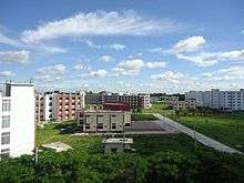
Rangpur town, covering an area of around 43 square kilometres, lies on the bank of the Ghaghat river, and was turned into a municipality back in 1869. The population of the Rangpur municipality as of 2006 is 251,699, with 52% male and 48% female, and the literacy rate is 54.6%. Establishment of Rangpur City Corporation, as Divisional City is now under way after the establishment of Rangpur Division in January 2010. The area of Rangpur City Corporation is estimated to be around 100 square kilometre accommodating about 6 million population by next Census of 2011. Rangpur city would be the fifth largest city of Bangladesh after Dhaka (125 million), Chittagong (30 million), Khulna (10 million) and Rajshahi (8 million) estimated population by the next 2011 census.
Education
Begum Rokeya University is the only university in Rangpur district. The Rangpur Medical College, situated in Rangpur is one of the major government medical colleges in Bangladesh. Carmichael College, established in 1916 by some leading zamindars, is a postgraduate college offering courses in 14 subjects in the faculties of arts, social science, science and commerce.[4] The most renowned educational institution in this region is Rangpur Cadet College. Other renowned institutions include Cantonment Public School & College,Rangpur(CPSCR), Rangpur Government College, Police Lines School and College and Rangpur Zilla School. Zilla School is established in 1832, this higher secondary school is known for the quality of education it offers.[5] Other prominent educational institutions include Rangpur Government College, Begum Rokeya College and Govt. Commercial Institute. Besides there is one polytechnic institute, one vocational institute, around 282 high schools, 722 government primary schools, 38 junior high schools, 193 NGO (Non Government Organization) operated schools and almost 370 Madrasahs in Rangpur. Rangpur Model College is now hnourse college.
Places of interest
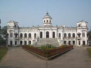
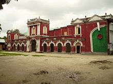
Just south of the city of Rangpur lies the Tajhat, a former "rajbari" or zamindar's palace. After the end of the British Raj, the building was abandoned and decayed rapidly, although it was used for a few years as a courthouse during the 1980s. In the year 2004, it was largely restored and turned into a museum with ancient inscriptions, art and coins from the area on display. RDRS (Rangpur and Dinajpur Rural Service) Bangladesh,[6] an NGO in northwest Bangladesh, has a large office and guesthouse/convention centre in the town of Rangpur.
A museum and women's training centre was established in Pairabondh, the birthplace of Begum Rokeya. It is half an hour drive away from Rangpur city. Apart from the Tajbari museum there is another museum at the heart of the town. The town is known as Green town for its beautiful garden and green park throughout the town.
There is a big Zoo at the heart of the city. There is an ancient auditorium named 'Town Hall' at the centre of the city, where different cultural programs are held. The economy of the people is weak since there is no major natural resource like minerals and industry. In the rural areas, there are no source of income for landless poor people. In the great Rangpur region, no economic development took place until the 90s, mainly because of the yearly flooding the region used to see before the making of "Teesta Barrage." The coal is found near this district. There is a large military cantonment in the town. "Bhinno Jogot" is a big theme park and a popular picnic spot which is situated 15 kilometres from Rangpur Town.
Near the stadium, there is a very beautiful place called 'Chicli vata' surrounding bij many lakes and rice fields.
JADU NIBASH – Radhaballav. An ancient house belonging to the former Prime Minister of Bangladesh (1979)
Media
Bangladesh Betar Rangpur (BBR) has Broadcasting station in Rangpur.Bangladesh Television (BTV) has satellite station in Rangpur. Rangpur Press Club is situated in the Rangpur town. Rangpur has almost 19 cinema halls. There are a number of locally published newspapers in the district.
Online Media
Bangladesh Betar Rangpur News paper: Dainik Dabanol(1981) www.dainikdabanol.com
Development Organisations
RDRS Bangladesh – previously Rangpur-Dinajpur Rural Service – has its main operational headquarters in Rangpur town at the RDRS Complex.[6] RDRS was established in 1972 following the War of Liberation, after assisting refugees in camps across the border in India. RDRS returned to help rehabilitate the disadvantaged northwest region of Rangpur-Dinajpur, providing relief, running health services, providing education, developing agriculture and roads, and also starting conscientisation applying the Frierian approach. It is the field program of the Geneva-based Lutheran World Federation. RDRS became a fully Bangladeshi NGO in 1997 with a national Board of Trustees and Executive Director. RDRS is still a major development actor across the northwest working with around 2 million landless and marginal farmers, indigenous minorities, vulnerable communities such as the river islands and 360 Federations, i.e. community-based organisations. The RDRS Rangpur Guesthouse based on the RDRS Complex is the leading hotel in town.
Notable people
- William Beveridge, British economist
- Roquia Sakhawat Hussain, writer and social worker
- Mashiur Rahman Jadu Mia, former Prime Minister (1979)
- Hussein Muhammad Ershad, former President of Bangladesh
- Anisul Huq, poet and writer.
- Rezwana Choudhury Bannya-Bangladeshi Rabindra Sangeet artist
- M. A. Wazed Miah, nuclear scientist
- Abu Sadat Mohammad Sayem,6th President of Bangladesh,first chief justice of Bangladesh
- Sajeeb Wazed Joy,Bangladeshi Young Global leader,ICT Consultant and Political campaigner.
- G M Quader,Bangladeshi politician and the former Minister of Commerce and former Minister of Civil Aviation
- Nasir Hossain,Bangladeshi all-round cricketer
- Dr.Rashid Askari,Bengali-English writer, fictionist,columnist, professor of English and current vice-chancellor of Kushtia Islamic University-Bangladesh.
- Ahmed Hossain, Chairman Rangpur District Board and Minister for Agriculture, Forest and Fisheries (Undivided Bengal)
- General Mustafizur Rahman, Former Chief of Army Staff of the Bangladesh Army.
- Mostafa Kamal, Chief Justice of Bangladesh.
- Sharif Imam, husband of Shahid janoni jahanara Imam
- Jahanara Imam, Bangladeshi writer and political activist.
- Abbasuddin Ahmed,Prominent Bhawaiya singer
- Rathindranath Roy,Founder of Bhawaiya academy and singer.
- Ferdausi Rahman,legendary folk singer.
- Hassan Mahmood Khandker, He is a Bangladeshi former Inspector General of Bangladesh Police
- Mohammad Nurul Islam,Former Governor of Bangladesh Bank.
Members of tenth Jatiyo Sangsad (2014 – )
The members of the national parliament are:[7]
- Rangpur-1 : Md. Moshiur Rahman Ranga [from Jatiya Party]
- Rangpur-2 : Abul Kalam Md. Ahasanul Hoque Chowdhury [from Awami League]
- Rangpur-3 : Alhaj Hussain Muhammad Ershad [from Jatiya Party]
- Rangpur-4 : Tipu Munshi [from Awami League]
- Rangpur-5 : H.N. Ashequr Rahman [from Awami League]
- Rangpur-6 : Dr. Shirin Sharmin Chaudhury [from Awami League]
References
- ↑ List of Divisional Commissioners – Cabinet Division – Bangladesh
- ↑ Abdus Sattar (2012). "Rangpur District". In Sirajul Islam and Ahmed A. Jamal. Banglapedia: National Encyclopedia of Bangladesh (Second ed.). Asiatic Society of Bangladesh.
- ↑ Banglapedia Map
- ↑ "Carmichael College, Rangpur". Banglapedia. Retrieved 11 September 2009.
- ↑ "Rangpur Zilla School". Banglapedia. Retrieved 11 September 2009.
- 1 2 RDRS Bangladesh
- ↑ "List of 10th Parliament Members". Retrieved 23 July 2015.
External links
| Wikimedia Commons has media related to Rangpur District. |
- Rangpur Municipality, Official website for Rangpur Municipality
- Rangpur Education
- Rangpur district, Information about Rangpur District