Gaibandha District
| Gaibandha গাইবান্ধা(প্রাচীন নাম ভবানী গঞ্জ) | |
|---|---|
| District | |
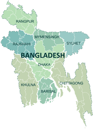
 Location of Gaibandha in Bangladesh | |
| Coordinates: 25°15′N 89°30′E / 25.25°N 89.50°ECoordinates: 25°15′N 89°30′E / 25.25°N 89.50°E | |
| Country |
|
| Division | Rangpur Division |
| Area | |
| • Total | 2,179.27 km2 (841.42 sq mi) |
| Population (2011) | |
| • Total | 2,430,627 |
| • Density | 1,100/km2 (2,900/sq mi) |
| Time zone | UTC+6 (BST) |
| Postal code | 5700 |
| Website |
www |
Gaibandha (Bengali: গাইবান্ধা জেলা, Gaibandha Jela also Gaibandha Zila) is a district in Northern Bangladesh. It is a part of the Rangpur Division. Gaibandha subdivision was established in 1875. Gaibandha was previously known as Bhabanigonj. The name was changed from Bhabanigonj to Gaibandha in 1875. Gaibandha was established as a district in 15 February 1984.[1]
Geography
Gaibandha has a total area of 2179.27 km².[2] It has boundaries with the Kurigram and Rangpur to the north, Bogra District to the south, Joypurhat, Dinajpur and Rangpur districts to the west, and Jamalpur and Kurigram districts, and the Brahmaputra River to the east. Gaibandha has seven upazillas and 82 unions. Bhramhaputra, Tista , Kartoa and Ghaghot are notable rivers in this district. Total river area of this district is 107.71 sq. km.[3]
Economy
The main occupations of Gaibandha district are agriculture 44.45%, agricultural laborer 27.72%, wage laborer 2.58%, transport 1.89%, commerce 9.11%, service 4.49% and others 9.76%. Total cultivable lands are 160397 hectares, fallow land are 56643 hectares[4]; the amount of crop: single crop 20.5%, double crop 58.5% and treble crop 21%; land under irrigation 27.16%. Main crops are paddy, wheat, jute, sugarcane, potato, brinjal, mustard seed, chili, onion, garlic and vegetables. There are 277 poultries, 273 dairies, 245 fisheries, 5 hatcheries, 16 nurseries and 2 artificial cattle breeding centers.
Demographics
The total population of the district is 24,30,627.[2] Total number of male and female is 12,30,938 and 11,99,689 respectively.[4] There are 7 upazillas, 82 unions and 1249 villages in Gaibandha.[4]
Language
Most people of Gaibandha speak Bengali dialects of Rangpur region. People living in the southern portion (Shaghata and Gobindaganj) have some accent of the dialects of Bogra region. A good many people of Char areas of Jamuna speak dialects of Mymensingh region.
Education
Education rate of Gaibandha is 54%. Among educational institutions, there are 3 government colleges, 41 non-government colleges, 4 government high schools, 287 non-government high schools, 31 junior high schools, 498 madrasas, 737 government primary schools, 546 non-government primary schools, 14 kindergartens, 83 satellite schools, 32 community schools, 1 primary teacher's training institute, and 1 agriculture training institute. Well-known educational institutions of Gaibandha District are:[5]
- University/college
- Solayman Nagar Technical School And Business Management College
- Gaibandha Institute of IT
- Ahammad Uddin Shah Shishu Niketon School & College
- Gaibandha Government College
- Gaibandha Government Women's College
- Naldanga Degree College
- Sadullapur Degree College
- Joyenpur Adarsha College, Sadullapur
- Sadullapur Mahila Mahabidyalay
- Adarsha College
- Abu Hossain Sarkar Women's College
- Agricultural Training Institute
- Animal research institute
- Technical College
- Asaduzzaman Girls College
- Dariapur Aman Ullah High School,Gaibandha
- Gaibandha sadar Upazila model college
- Palashbari Govt. College
- Mahimaganj College (Degree)
- Bhatgram Anath Academy
- Shadullapur Arun Alo Residencial School & College
- Bhatgram High School & College, Sadullapur
- Secondary schools
- Pearapur High School, Gaibandha
- Solayman Nagar Technical School And Business Management College
- Palashbari S.M. Pailot High School
- Ahammad Uddin Shah Shishu Niketon School & College
- Gaibandha Government Boys' High School
- Gaibandha Government Girls' High School
- Gaibandha Islamia Multipurpose Boys High School
- Asaduzzaman Girls School
- Laxmipur Bi-Lateral High school and College, Laxmipur, Gaibandha
- Kantanagar Binoy Bhushan Bi-Lateral High school, Sadullapur
- Bhangamor High School, Sadullapur
- Niamotnagar High School, Sadullapur
- Nizam Uddin High School
- NHS Modern High School
- Bhatgram High School & College, Sadullapur
- Dariapur Aman Ullah High School, Gaibandha
- Madrasha
- Kamarjani Bonik Fazil Degree Madrasha
- Nutan Bandar Girls Dakhil Madrasha
- Mahimaganj Alia Kamil Madrasha (university)
- Niamatnagar N U Shah Senior Madrasa, Sadullapur
- R A Gani school & College,Sadullapur.
Health
There is a general hospital and six government hospital in Gaibandha. 89% of total population get the facility of sanitation. The only general hospital of the district is Gaibandha Sadar Hospital which is located at the Gaibandha Sadar.[4]
Administration
Gaibandha District is divided into 7 upazilas/thanas, which are further divided into 82 union parishads, and 1244 villages. The upazilas/thanas of the district are:
| upazila | population (2011)[6] |
|---|---|
| Fulchhari Upazila | 165334 |
| Gaibandha Sadar Upazila | 437268 |
| Gobindaganj Upazila | 514696 |
| Palashbari Upazila | 244792 |
| Sadullapur Upazila | 287426 |
| Sundarganj Upazila | 461920 |
| Saghata Upazila | 267819 |
Included in these upazilas are 3 municipalities, which have a total of 18 wards and 56 mahallas. The municipalities are Gaibandha city,[5] Gobindaganj and Sundarganj.
Notable people
- Ahmed Hossain, Chairman Rangpur District Board, Minister for Agriculture, Forest & Fisheries
- Shah Abdul Hamid, First Speaker of Bangladesh Jatiya Shangshad
- Akhteruzzaman Elias, novelist and writer
- Abu Hussain Sarkar, Chief Minister of East Pakistan in 1955, Health Minister of combined Pakistan in 1956.[7]
- Mahabub Elahi Ronju Bir Protik, valiant freedom fighter and company commander of 'Ronju company of Mukti Bahini' at Gaibandha area during the glorious liberation war of Bangladesh in 1971.
Members of tenth Jatiyo Sangsad (2014 - )
| Area | Elected MP | Party |
|---|---|---|
| Gaibandha-1 | Shamim Haider Patwary | Bangladesh Awami League |
| Gaibandha-2 | Mahabub Ara Begum Gini | Bangladesh Awami League |
| Gaibandha-3 | Dr. Md. Eunus Ali Sarkar | Bangladesh Awami League |
| Gaibandha-4 | Md. Abul Kalam Azad | Independent |
| Gaibandha-5 | Fazle Rabbi Miah | Bangladesh Awami League |
Notable places
See also
References
| Wikimedia Commons has media related to Gaibandha District. |
- ↑ "Jēlāra paṭabhūmi" জেলার পটভূমি [Background of the district]. Gaibandha (in Bengali).
- 1 2 Zahurul Qayum (2012). "Gaibandha District". In Sirajul Islam and Ahmed A. Jamal. Banglapedia: National Encyclopedia of Bangladesh (Second ed.). Asiatic Society of Bangladesh.
- ↑ "Bhaugalika pariciti" ভৌগলিক পরিচিতি [Geography]. Gaibandha (in Bengali).
- 1 2 3 4 "Ēkanajarē jēlā" একনজরে জেলা [District at a glance]. Gaibandha (in Bengali).
- 1 2 "Welcome - Gaibandha Paurashava". gaibandhapaurashava.org.
- ↑ "Community Report Gaibandha Zila June 2012" (PDF). Bangladesh Bureau of Statistics. Archived from the original (PDF) on 13 November 2012. Retrieved 28 March 2013.
- ↑ "Prakhyāta byaktitba" প্রখ্যাত ব্যক্তিত্ব [Renowned personalities]. Gaibandha (in Bengali).
- 1 2 3 "Darśanīẏa sthāna" দর্শনীয় স্থান [Sightseeing]. Gaibandha (in Bengali).