Rangpur City
| Rangpur রংপুর | |
|---|---|
| City | |
      From top: Rangpur Cadet College, Tajhat Palace, Town Hall, Parjatan Motel, Begum Rokeya University, Police Lines School and College | |
| Nickname(s): Green City | |
 Rangpur Location in Bangladesh | |
| Coordinates: 25°34′N 89°15′E / 25.56°N 89.25°ECoordinates: 25°34′N 89°15′E / 25.56°N 89.25°E | |
| Country |
|
| Division | Rangpur Division |
| District | Rangpur District |
| Establishment | 16 December 1769[1] |
| Municipality | 1869[1] |
| City Corporation | 1 July 2012[2] |
| Government | |
| • Type | Mayor–Council |
| • Body | Rangpur City Corporation |
| • City Mayor | Mostafizar Rahman Mostafa (Jatiya Party)[3] |
| Area | |
| • Metro | 28 km2 (11 sq mi) |
| Elevation | 34 m (112 ft) |
| Population (2017 (est)) | |
| • City | 120,000 |
| • Density | 980/km2 (2,500/sq mi) |
| Time zone | UTC+6 (BST) |
| Postal code | 5400[4] |
| National Calling Code | +880 |
| Calling Code | 521 |
| Website |
rpcc |
Rangpur (Bengali: রংপুর) is one of the major cities in Bangladesh and Rangpur Division. Rangpur was declared a district headquarters on 16 December 1769, and established as a municipality in 1869, making it one of the oldest municipalities in Bangladesh.[1][5] The municipal office building was erected in 1892 under the precedence Raja Janaki Ballav, Sen. Chairman of the municipality. During the period of 1890, "Shyama sundari khal" was excavated for improvement of the town. The Municipality is located in the north western part of Bangladesh.[1] A Recently established public university of Bangladesh named "Begum Rokeya University, Rangpur" is situated in the southern part of the city. Previously, Rangpur was the headquarters of Greater Rangpur district. Later the Greater Rangpur district was broken down into the Rangpur, Kurigram, Nilphamari, Lalmonirhat and Gaibandha districts. In the great Rangpur region, little economic development took place until the 90s, mainly because of the yearly flooding the region used to see before the making of the Teesta Barrage. Coal is found near this district. There is a large military cantonment in the town.
History
Rangpur was conquered by the army of Raja Man Singh, a commander of the Mughal emperor, Akbar, in 1575, but it was not until 1686 that it was fully integrated into the Mughal Empire. Names of places like Mughalbasa (literal meaning being a locality of the Mughals), and Mughalhat (literal meaning a "local market" organised by the Mughals) bear testimony to the Mughal Association and past of Rangpur and its hinterland. Later on, Rangpur passed under the control of "Sarker" of Ghoraghat. During the period of the British East India Company, the Sannyasi Rebellion took place.[6] Rangapur Ghoraghat has been mentioned in the Riyaz-us-Salatin. During the early period of the company rule fakir-sannyasi resistance and peasant rebellion were held in Rangpur.
Geography
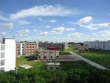
Rangpur town is the divisional headquarters. The soil composition is mainly alluvial soil (80%) of the Teesta River basin, and the remaining is barind soil. The temperature ranges from 32 degrees Celsius to 11 degrees Celsius, and the annual rainfall averages 2931 mm. Rangpur town, covering an area of around 28 square kilometres, lies on the bank of the Ghaghat river, and was turned into a municipality back in 1869. The population of the Rangpur municipality as of 2006 is 251,699, with 52% male and 48% female, and the literacy rate is 54.6%. Establishment of Rangpur City Corporation, as Divisional City is now under way after the establishment of Rangpur Division in January 2010.
Climate
Rangpur has a humid subtropical climate. The Köppen-Geiger climate classification is Cwa. The climate of Rangpur is generally marked with monsoons, high temperature, considerable humidity and heavy rainfall. The hot season commences early in April and continues till July. The average annual temperature in Rangpur is 24.9 °C (76.8 °F). About 2,192 mm (86.30 in) of precipitation falls annually.
| Climate data for Rangpur | |||||||||||||
|---|---|---|---|---|---|---|---|---|---|---|---|---|---|
| Month | Jan | Feb | Mar | Apr | May | Jun | Jul | Aug | Sep | Oct | Nov | Dec | Year |
| Average high °C (°F) | 24.4 (75.9) |
27.1 (80.8) |
31.5 (88.7) |
34.1 (93.4) |
32.6 (90.7) |
31.8 (89.2) |
31.7 (89.1) |
31.8 (89.2) |
31.8 (89.2) |
30.9 (87.6) |
28.4 (83.1) |
25.6 (78.1) |
30.1 (86.3) |
| Average low °C (°F) | 10.3 (50.5) |
12.0 (53.6) |
15.9 (60.6) |
21.0 (69.8) |
23.0 (73.4) |
24.7 (76.5) |
25.7 (78.3) |
26.3 (79.3) |
25.6 (78.1) |
22.3 (72.1) |
16.4 (61.5) |
12.2 (54) |
19.6 (67.3) |
| Average precipitation mm (inches) | 9 (0.35) |
12 (0.47) |
26 (1.02) |
78 (3.07) |
291 (11.46) |
481 (18.94) |
461 (18.15) |
352 (13.86) |
315 (12.4) |
154 (6.06) |
10 (0.39) |
3 (0.12) |
2,192 (86.3) |
| Source: Climate-Data.org,Climate data | |||||||||||||
Rangpur City Corporation Master Plan
1.1 Introduction

Rangpur is one of the newly established City Corporations of the country. Apart from the status of a City Corporation it is the administrative headquarters of the Rangpur Division comprising the old greater Rangpur and Dinajpur districts. The attractive central location and the seat of an age old administrative centre dating back to the early days of British rule, Rangpur has the potential to develop not only as an administrative centre but also as an economically vibrant area housing substantial urban population of the country (Map 1.1 shows the location of Rangpur City in the national context).
1.2 Project Background
At the time of upgrading the Rangpur paurashava area into a City Corporation, the jurisdiction of the city has been extended from 41.18 km2. to about 205 km2. But the city does not have a physical development plan to guide its urbanization in to the desired direction. In the eighties of the last century a package of plans in the form of Structure Plan and Action Plan was prepared with UNDP assistance under the auspices of Urban Development Directorate. The plan package was prepared for the area of the then jurisdiction of the Rangpur paurashava. The plan never became a tool for the promotion of development and development control of the paurashava area as it was not legalized through enactment. In the absence of an effective and legally supported Plan Rangpur like most of the age old cities continued to develop with narrow roads and very limited urban facilities.
In this situation it has become imperative to prepare physical development plan for its orderly development. The up gradation of the paurashava into a City Corporation and as the HQs of Rangpur Division, the city cannot afford to continue the trend of ‘free for all’ type of physical development. Moreover, without a plan it has become increasingly difficult to spend government allocation or development partners’ assistance for effective infrastructure development and utility provisions. In this backdrop Local Government Engineering Department has taken the initiative of preparing a Master Plan Package comprising Structure Plan, Urban Area Plan and Detailed Area Plan for Rangpur Divisional Town which soon was up graded to the status of a City Corporation.
1.3 Vision & Objectives of the Plan
Ever since the independence of Bangladesh the country is experiencing high urbanization pressure. During 1974-2001 period growth of urban population increased from 8 percent to 23 percent. Sixth Five Year Plan envisages that by 2015 about 33 percent of the total population of the country will live in urban areas. Being the fourth largest city in terms of population Rangpur has to face enhanced challenges in providing urban services for all its citizens. The Sixth Five Year Plan emphasizes on the effective functioning of the Cities through planning, establishing good governance, resource mobilization and enhancing scheme implementation capacity to meet the urban challenge and ensure proper delivery of all urban services. The cities of the country should be served by effective road
network characterized by congestion free, pedestrian friendly, safe and sound communication system; improved waste management; improved environment and infrastructure; adequate potable water supply; proper recreation facilities; effective primary health facilities; proper drainage system to prevent water logging and expanded commercial complexes for the development of economic activities. The Master Plan thus endeavors in the creation of a harmonious living condition in Rangpur City by ensuring all these where all citizens will enjoy the benefit of modern living with all urban facilities at affordable and sustainable condition.
The main objective of Structure Plan is to provide elaborate policy guidelines for the planned development of the newly up graded Rangpur City area. Usually Structure Plans bear following objectives:
a) Interpret the national urban strategies and policies and elaborate it according to the city condition for which it is prepared;
b) Identify the sectoral agencies and their projects that are likely to influence the development of the city;
c) Identify the probable fields where public and private partnership development projects will bring maximum benefit to the citizens;
d) Adopt suitable standards for all urban amenities which can be provided at affordable price;
e) Provide framework for Detailed Area Plan/Action Plan;
f) Indicate the basis of coordination between government agencies in the implementation of various schemes for the physical development which will directly or indirectly influence the growth of the city;
g) Formulate in details various policies to guide development and development control of the city.
h) Also provide adequate policy frame work for better cooperation between various agencies of the government to foster inclusive city governance.
i) Bring the urban development issues with its problems and opportunities before the government for support and implementation.
1.4 Components of the Plan Package
The Plan package has four components:
- Framing of a long term Development Strategy on the basis of national perspective indicating long term policy outline, vision, major objectives and targets encompassing areas beyond the City jurisdiction also;
- Preparation of Structure Plan for the entire jurisdiction of the Rangpur City area for a period of 20 years on a map of R.F 1:10,000 scale by defining the future development and broad land classes including areas of open space and strategy for future infrastructure development;
- Preparation of Urban Area Plan on a map of RF 1: 1980 scale as an interim development tool to materialize the vision set in the Structure Plan for the developed and the developing areas for a period of 10 years;
- Preparation of Detailed Area Plan including Action Plans/Project Plans on maps of RF 1:990 scale for the areas need development in near future within 3–5 years.
1.5 Custodian of the Plan
Clause 16 of Schedule 3 of City Corporation Act 2009 describes the function of City Planning Department of the City Corporations. This section authorizes the City Corporations to prepare Master Plan for the physical development of the Cities. This implies that the custodian of the plan is the respective City. As Rangpur City Corporation has been created very recently and is yet to build capacity to accomplish such a huge work, Local Government Engineering Department has taken the responsibility of preparation of Master Plan Package on behalf of Rangpur City. On preparation, approval and enactment the plan package will be the property of Rangpur City and naturally Rangpur City Corporation will be its custodian.
1.6 Duration and Amendment of the Plan
Usually Structure Plan package is prepared for a period of 20 to 25 years. ToR envisages the preparation of the plan for twenty years. So the plan will remain valid for the period 2014-2034. Structure Plan needs periodic review to match it with the time and it is recommended that the first review of the plan should be initiated at the end of 2019.
1.7 Structure Plan
Structure Plan is basically concerned with development of broad strategies for managing and promoting organized urban development over the medium and long term and attempts to integrate economic, physical and environmental objectives. It differs from the Master Plans as it concentrates on the city’s broad structure only. It is not concerned with details of physical layout and details of any development area as implementation of the area is a futuristic matter. Future is uncertain and it is not possible to predict with any degree of precision about the future of socio-economic and even potential aspects which determine the extent of urbanization. Structure Plan provides a broad framework for development activities over a long period of time in and around the city. The major components of the plan are:
- An overview of demographic, economic, social, physical and infrastructure features
- Trends and changes likely to take place within the planning period
- An analysis of the critical issues related to urbanization process of the city
- Identification of major opportunities and constraints
- Indication of preferred areas of urban expansion within the city
1.7.1 Format of the Structure Plan
The Structure Plan consists of
a) Explanatory Report
b) Composite Policies Planning Map
a) Explanatory Report
The Explanatory Report provides an account of the plan with the help of statistical tables, maps and graphs necessary to explain the plan. The Report also contains maps on a scale that is appropriate on the subjects that the report carry and convenient for inclusion in a Report (A4 size).
Contents of the Report
The Structure Plan Report contains policies on the following topics:
- Spatial Development
- Agriculture
- Residential Facilities
- Transport and Communication
- Drainage
- Water Supply
- Solid Waste Management
- Sanitation
- Electricity Supply
- Gas Supply
- Industry
- Trade and Commerce
- Tourism and Recreation
- Environment
- Disaster Management
- Security and Safety
- Social Service
- Governance
- Water Body
b) Structure Plan Composite Policies Map
The Composite Policies Map shows the broad structure of the city indicating areas of future expansion, built up areas and their use nature, major transportation routes and water bodies, rivers and canals.
As per ToR following map has to be submitted:
- Structure Plan Map at 1: 10,000 Scale
1.7.2 Structure Plan Area Coverage
Rangpur became an urban center since 1869 when Rangpur Municipality was created with a jurisdiction of 26.20 km2. (6474.47 acres). In 1982 the jurisdiction was enhanced to 41.18 km2. (10175.90 acres). In 2010 the creation of Rangpur Division with Rangpur Paurashava as its HQs necessitates the up gradation of the status of the paurashava in to a City Corporation. With the up-gradation of the paurashava in to City a very large agricultural area all around the old paurashava area has been included within the City boundary. The City now covers 207 km2. (51344.25 acres). The creation of the City was made official through publication of the names of the 112 mauzas in the gazette on June 8, 2012. ToR envisages planning coverage of the entire City area. As such the area covered by the 112 mauzas will form the Structure Plan area with the exception of the restricted area of Rangpur Cantonment located in the heart of the city. Thus the Rangpur City Structure Plan covers 50677.77 acres or 205.09 sq. k. m. A detail of the Rangpur City Structure Plan area coverage is provided in Table 1.1 and Map 1.2.
Table 1.1 Details of Rangpur City Structure Plan Coverage
| Description | Area
(acre) |
Area
(sq. k. m.) |
| Total area of Rangpur City including Rangpur Cantonment | 51344.13 | 207.78 |
| Restricted Area (Cantonment) | 666.355 | 2.70 |
| Area Coverage of Rangpur City Structure Plan | 50677.77 | 205.09 |
Source: Prepared by the consultants on the basis of Gazette publication and Land use survey.
1.8 Stakeholders’ Consultation
Participation of the stakeholders is a key for successful preparation as well as implementation of a City Master Plan. In the present day plan preparation practice thus stakeholders’ participation in the form of Focus Group Discussion or any other means of view exchange meetings with the stakeholders has been made compulsory. A three-stage consultation has been carried out in the preparation of the Master Plan for Rangpur City. In the first stage people have been apprised about the plan, its intent and process of the plan preparation program. Through second stage consultations attempts have been made to collect information about people’s view on the future of city’s development. Information on how the people of Rangpur City want to see their city in the future has been collected through this stage of consultation. The third or the final consultation was made to derive opinion of the citizens on the proposed draft plan in order to fine tune it according to their recommendations and then finalize the plan.
Economy
The city is the commercial hub for the surrounding districts. The city centre has number of government and private banks, insurance companies, residential hotels, Chinese and Indian restaurants, fast food, sweet shops, gift shop and many more. It is one of the most important economic zones in Bangladesh, because of its global positioning.
Places of interest
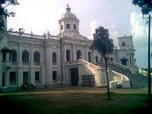

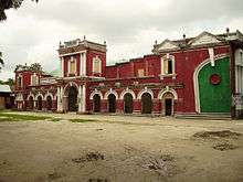
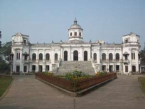
Tajhat Palace
Tajhat Palace is located at Tajhat, the southern end of Rangpur city. It was the earlier high court building established in 1984 called the Tajhat, a former zamindar's palace. After the end of the British Raj, the building was abandoned and decayed rapidly, although it was used for a few years as a courthouse during the 1980s. In 2004, it was largely restored and turned into a museum which hosts a collection of Blackstone Hindu carvings, calligraphic art from the Mughal period and other objects d'art and coins from the area on display. Due to lack of funding, the museum is sometimes closed.[7]
The place is situated three km on the south–east outskirts of the town of Rangpur. Probably this place was built by Maha Raja Kumar Gopal Lal Ray in the beginning of the 20th century from 1984 to 1991. The palace was used as a Rangpur high Court branch of the Bangladesh Supreme court in 1995. The palace was declared as a Protected monument by the department of archaeology. recognising its outstanding archaeological value the government of Bangladesh decided to shift the Rangpur museum here in 2002. Accordingly, the palace in being partly used as Rangpur museum since 2005.
Carmichael College
Carmichael College is one of the old colleges in Bangladesh established in 1916. The main attraction of this college is its administrative building (which houses the Bangla department). The building was designed with an Indo-Saracenic Revival architecture.
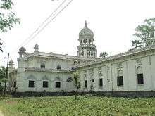
Town Hall
There is an ancient auditorium named 'Town Hall' at the centre of the city, where different cultural programs are held.
Jadu Nibash
Located in Radhaballav next to the Rangpur Government College. Home of Late Mashiur Rahman Jadu Mia. It is an ancient house, about hundred years old. The house was probably built and owned by Raja Gopal Lal Rai Bahadur at the same time that the Rangpur District Council, Rangpur Town Hall and the famous Tajhat Palace buildings were built.
Zoo
Rangpur central zoo is one of the main amusement and recreation spot of Rangpur city. With an area of 20.27 acre of lush green trees and grasses, the Rangpur zoo is located east side of Hanuman-tola road beside police-line, not far from Rangpur district Administration office. The Zoo has 193 individual animals of 28 species.[8] Many wild animals are available to attract the visitors. A few of them are The Bengal tiger, African lion, Black Panther, Rhinoceros, Leopard, Hippopotamus, Peacocks, Alligators, Turtles, Spotted Deer, different kinds of Birds, Snakes and so on.
The Rangpur zoo was built in the 1880s. Bangladesh University of Engineering and Technology (BUET) completed a digital survey and feasibility study of "Dhaka And Rangpur Zoo Modernization Project" to upgrade the facilities to international standard.[9][10][11]
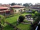
Binodon Uddyan
"Binodon Uddyan" is a massive park located in the middle of the city. A Shishu Park (children's park), lake and a large restaurant are situated inside of this park. The mini Tajmahal also latest attraction.
Vinno Jogot
"Vinno Jogot" ia s well decorated amusement park, which is located about 12 kilometer distance from Rangpur city. Thousands of people come everyday for refreshment with green environment. A vast lake surrounded across the park. A planetarium has existed their. Shisu park, various ride, mural of world's seven wonders charm tourists.
Kellaband Mosque (Masjid)
Kellaband Mosque is situated at C.O. Bazar on the north of Rangpur-Dinajpur Highway 02 km north-west of Rangpur town. This three-dome mosque is about 200 years old. A concrete well and an ancient cemetery are lying beside the mosque.
Pirgacha Landlord House
The Manthana Kingdom Estate was established sometime around 1100 AD. Her Royal Highness Maharani Joy Durga Devi Chaudhurani of Rangpur was the most influential and famous ruler of the kingdom. After the death of His Royal Highness Rajah Rajendra Narayan Roy Choudhury, the Monthana Kingdom Estate was divided into two parts among his two sons Rajah Harendra Narayan Roy Choudhury and Rajah Bhairab Narayan Roy Choudhury of Rangpur. As a result, the landlord house also divided into two parts. After the death of HRH Rajah Harendra Narayan Roy Choudhury his son HRH Rajah Mahendra Narayan Roy Choudhury succeeded the kingdom. After his death HRH Rajah Bhupendra Narayan Roy Choudhury succeeded to the throne of the kingdom and was the last crowned king of this kingdom estate. His son HRH Prince Jyotirindra Narayan Roy Choudhury was born in 1947 and is the crown prince of the estate. Soon after the birth of HRH Jyotirindra Narayan Roy Choudhury, India and East Pakistan got independence from imperial British rule and the partition of Bengal took place. HRH Prince Jyotirindra Narayan Roy Choudhury of Rangpur now resides in Calcutta, India with his family. His son HRH Prince Rupendra Narayan Anirban Roy Choudhury of Rangpur who uses the name Anirban Roy Choudhury is the present Titular Crown Prince of the kingdom-estate. The Pirgaccha Landlord House popularly known as the Manthana Palace or Manthana Rajbari is a massive structure spread over hundreds of acres of land and houses ponds, lakes, buildings, temples, and various other assets. HRH Princess Kabita Rani Roy Choudhury is the present legal owner of the entire kingdom-estate. The Kachari House of the Manthana Palace is now used as Pirgasha Registrar Office.
Devi Caudhuranir Jamindar Bari
The Landlord-King of Pirgacha sub district HRH Rajah Narendro Narayan Roy Choudhury, son of HRH Rajah Raghabendra Narayan Roy Choudhury died in 1765 without any legacy. Then the wife of the late King, HRH Maharani Joy Durga Devi Chaudhurani of Rangpur managed the kingdom for three decades. HRH Maharani Joy Durga Devi Chaudhurani is popularly known as Devi Chaudhurani in history and was one of the most successful and popularly known rulers of the kingdom. During the time of Sanyasi Bidroho (ascetic revolution) for the independence of India, she along with Bhabani Pathak raged war against the British. In this insurgency Collector Richard Gudland and army commander Lieutenant Brenan, scared of the war situation, forfeited the kingdom from Devi Chaudhurani. However the imperial British could not keep the kingdom forfeited from the illustrious Maharani, and soon after she again came to manage the kingdom and she ruled until 1791. Later in history, the famous Bengali novelist, Bankim Chandra Chattopadhyay, who also happened to be the Collector of Rangpur and under the employment of the British rule, wrote the famous novel Devi Chaudhurani to portray her as a dacoit-queen. The novel has been adapted into very famous movies with the 1974 movie starring Suchitra Sen in the lead. And National Award winning director Rituporno Ghosh is adapting the novel into another movie in recent times, in which Aishwarya Rai Bachchan will play the lead role of Devi Chaudhurani. However the novel has tarnished the characted and image of Her Royal Highness Maharani Joy Durga Devi Chaudhurani to a great extent. His Royal Highness Rajah Bhupendra Narayan Roy Choudhury of Rangpur was the last king of the kingdom-estate. An earthquake damaged much of the palace built by Devi Chaudhurani. However the palace was rebuilt several times and is a sprawling structure spread over several hundreds of acres. The property, land and the assets of the estate kingdom is presently legally owned by Her Royal Highness Princess Kabita Rani Roy Choudhury of Rangpur, who lives in Kolkata, India. Her son His Royal Highness Prince Rupendra Narayan Anirban Roy Choudhury of Rangpur who commonly uses the name Anirban Roy Choudhury is the present Titular Crown Prince of the estate-kingdom. HRH Prince Anirban Roy Choudhury is currently studying the law at Symbiosis Law School and lives in Pune, Mumbai, New Delhi and Kolkata.
Itakumari Jamindar Bari
Itakumari Landlord house was established in the 19th century. Shibchondro elder son of landlord Rajarai was the founder of Itakhula Landlord house. Now most of the building are ruined . Now a well two large pond and elderly building witness of time. point to be noted that leaders of the public rebellion Devi singha and his assistant Harram sen one time on a time get the owner by forcing. Again Shibchanda and Devi Chowdhurani lead the public rebellion and free the people of Rangpur from Devi singha's torture.
Deowan Bari Jamindaar Bari
The Deowan Bari Jamindaar Bari was built by Fonivuson Mojumdar. Fonivuson Mijumdar was the son of Landlord Radharomon and mother Kusum Kumari Devi who was the second wife of Radharomon. He was born in 1892. This landlord house is a small 2 storied building. but the main gate of the house is like a Mughal Castle – gate. After ban of the Real estate tenancy practices in 1952 the house was auctioned. The property was purchased by one Nosor Ghatial who hailed from Kurigram. Now there is a school and some business centres. It is located at Deowan Bari road in Rangpur near the town.
Pirgachha
Pirgachha is one of the Upazilas in Rangpur that carries some interesting aspects. The name is derived from some unknown "pir"(religious guru), buried under a tree("gach"). In other words, there was this tomb of a "pir" under a big tree in Pirgachha. Pirgachha has a Rajbari, home of the Jomider (barons, if you will, or landlord, appointed by the King at that times). This one historic residence is now almost ruined. Also, there is a minitarure prayer place such as a mosque (for Muslim) and a mondir(for Hindu) built together. It shows a friendly Hindu-Muslim community at those ages.
Chicli vata
Near the stadium, there is a place called 'Chicli vata' surrounding by many lakes and rice fields.
Other Places
There is a large military cantonment in the town. Apart from the Tajbari museum there is another museum at the heart of the town. The town is known as Green Town for its gardens and green parks throughout the town.
Education

Major educational institutes in the city including:
Universities:
Medical & Dental Colleges:
- Rangpur Medical College
- Prime Medical College
- Rangpur Community Medical College
- Northern Private Medical College.
- Rangpur Army Medical College
- Kasir Uddin Memorial Medical College
- Rangpur Dental College
Polytechnic Institutes:
Colleges:
- Begum Rokeya College
- Carmichael College[12]
- Colectorate School and College
- Carmichael Collegiate School and College
- Rangpur Model College
- Police Lines School and College
- Rangpur Cadet College
- Cantonment Public School And College, Rangpur
- Rangpur Technical School And College
- Rangpur Government College
- RCCI Public School & College
- Lions School & College
- The Millennium Stars School & College
- Somaj Kolyan Women School & College
- Residential Model School and College
- Mahigong College
- Rangpur Public School & College
- Uttom College
- Rangpur City College
- Robertson Gonj Girls High School & College
- Siddique Memorial School & College
- Dhap Lalkuthi High School & College
Affiliated Colleges:
- International Institute of Applied Science and Technology, Rangpur
Schools:
- Cantonment Public School And College, Rangpur
- Rangpur Zilla School
- Rangpur Govt. Girls' High School
- Govt. Commercial Institute
- Bir Uttam Shaheed Samad High School
- Rangpur High School
- Salma Girls High School
- Afanullah High School, Alamnagar
- Adasha High School, Babukha
- Shalbon Pauro Girls High School
- Tajhat High School
English Medium School:
- The Millennium Stars School & College
- Shahan International School
- Nalanda International School
- International Grammar School
- BIAM Laboratory School
Healthcare
Rangpur is well known for its healthcare facilities throughout the north-Bengal districts. There are hundreds of hospitals, private clinics, diagnostic centres situated all over the city. The Rangpur Medical College Hospital (RMCH), a tertiary level thousand bed facility public hospital with teaching facility in graduate and post graduate medical education. The campus of Rangpur Medical College is located in the northwest area of Rangpur. It is 210 kilometres from the Rajshahi District and 330 kilometres from Dhaka and is located next to the inter-country highway that connects India to Nepal. Prime Medical College hospital (750 beds), Doctor's Community Hospital (500 beds), Northern Private Medical College Hospital, Christian missionary hospital are the well-known private institutes. Other government institutes include a children hospital, a chest hospital and an infectious disease hospital.
A 1000 bed-hospital known as Health City is under construction aiming to provide medical treatments and surgeries.
Online News Portal
Latest Bangla Newspapers Online. Get Breaking News from Rangpur Crime News www.rcn24bd.com
Newspaper
There are a number of locally published newspapers in the district. Locally published newspapers and periodicals include Online News Portal BNN (Bangladesh National News) Chief Editor-Mahmudur Rahman Dollar (ED-AMADER ODHIKAR)(2016)web-www.bangladeshnationalnews.com. Rangpur Onlinelivenews24(2012), Desh71(2012), Crime News (2005), Daily Rangpur Chitra (2009),Daily Akhira"(1990) Dabanal (1980), Rangaprovat (1987), Juger Alo (1992), Dainik Paribesh (1994),Daily Gonoalo(2012) Dainik Rangpur (1997), Weekly Atal (1991), Rangpur Barta (1996) and Weekly Bajrakantha (Pirganj). Former newspapers which are no longer published include Rangapur Bartabaha (1847), Rangapur Dik Prakash (1861), Rangapur Darpan (1907), Uttar Bangla (1960) and Pravati (1955).[13]
Transportation
The main transport systems used in the city are cycle rickshaws, auto rickshaws (mainly known as baby-taxis or CNGs), buses, mini-buses and cars. There are about 50,000 rickshaws running each day.
Roads
Rangpur is well connected by highways to Chittagong and Dhaka, as well as other parts of Rangpur. It takes about 6 to 7 hours by road to reach the capital Dhaka by National Highway 5. Bus services to other major districts are also available from Rangpur. Highway links to India have been established through the Asian Highway 2.
Railway
The Rangpur Railway Station is the main railway station providing trains on national routes operated by the state-run Bangladesh Railway. Rangpur Express
Air
The city of Rangpur is served by Saidpur Airport, located at the north of the city. Saidpur airport is a domestic airport. Saidpur Airport is connected through several private airlines such as Novoair, US-Bangla Airlines, Regent Airways & Biman Bangladesh Airlines a government airline with Capital city of Bangladesh Dhaka.
Dialect
Many Rangpur natives speak Rangpuri language. Rangpuri is an Indic language spoken by ten million Rajbongshi people in Bangladesh and five million in India, where they are known as Rajbanshi. Many are bilingual in either Bengali or Assamese. Rangpuri goes by numerous names. In Bangladesh, these include Rangpuri, Bahe Bangla, Anchalit Bangla, Kamta, Polia. The main dialects are Western Rajbanshi, Central Rajbanshi, Eastern Rajbanshi and Hill Rajbanshi (also known as Koch language).
Sports
The most popular sport in Rangpur is cricket, although football is also popular. There is a 10,000+ capacity stadium in the city. It is known as Rangpur Stadium. It is used for football and other sports. Besides different organisation share to stage a show there occasionally. There are another ground known as Cricket Garden[14] and is mainly used for cricket. There are also a few sports training academies in the city. In domestic Twenty20 cricket, Rangpur has a Bangladesh Premier League franchise known as Rangpur Riders. On December 2012, I Sports bought the Rangpur franchise for $1.01 m. Notable players from Rangpur who have played for the national team include Nasir Hossain,[15] Suhrawadi Shuvo.[16]
Notable people
- Annette Beveridge, British Indologist, known works being the translations of the Baburnama[17] from the Turki (Turkish) language, and the Humayun-nama from Persian.[18][19]
- William Beveridge, British economist who wrote the Beveridge Report that influenced United Kingdom to implement welfare state policies after World War II.
- Begum Rokeya Shakhawat Hossain, who was most famous for her efforts on behalf of gender equality and other social issues.
- Mashiur Rahman Jadu Mia (Politician, Founding member of BNP and Senior Minister with the rank of a Prime Minister in 1979).
- Abu Sadat Mohammad Sayem, 6th President of Bangladesh, first chief justice of Bangladesh.
- Hussain Muhammad Ershad, former President of Bangladesh.
- Anisul Hoque, author, novelist, dramatist, and journalist.
- M. A. Wazed Miah reputed Bangladeshi nuclear scientist who was former Chairman of the Bangladesh Atomic Energy Commission. He is the husband of Prime Minister Sheikh Hasina Wazed.
- Nasir Hossain, prominent Bangladeshi all-round cricketer.
- Rezwana Choudhury Bannya, a Rabindra Sangeet artist.
- Dr. Rashid Askari, Writer, columnist, academic and the current vice-chancellor of Islamic University, Bangladesh.
- General Mustafizur Rahman, Former Chief of Army Staff of the Bangladesh Army.
- Mostafa Kamal, Chief Justice of Bangladesh.
- Sharif Imam, husband of Shahid janoni jahanara Imam
- Jahanara Imam, Bangladeshi writer and political activist.
- Abbasuddin Ahmed, Prominent Bhawaiya singer
- Rathindranath Roy, Founder of Bhawaiya academy and singer.
- Ferdausi Rahman, legendary folk singer.
- Hassan Mahmood Khandker, He is a Bangladeshi former Inspector General of Bangladesh Police
Gallery
 Tajhat Palace.
 Shapla Chottor.
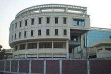
 Zilla Porishod Building.
- Parjatan Motel.
.jpg) Terminal Mosque (Masjid).
Terminal Mosque (Masjid). Rangpur Modern.
 Payra Chottor.
 Begum Rokeya Memorial Centre.
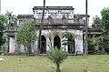 Jadu Nibash - an ancient house
 Ekattorer Boddho Bhumi - Memorial of Town Hall Massacre during 1971
Twin towns and sister cities
Rangpur's twin towns and sister cities are:
References
- 1 2 3 4 "Journey to Rangpur City Corporation". Archived from the original on 17 June 2015. Retrieved 17 June 2015.
- ↑ Our Correspondent, Rangpur (2 July 2012). "Rangpur turns city corporation". Thedailystar.net. Retrieved 11 June 2013.
- ↑ http://www.kalerkantho.com/online/national/2017/12/22/580409
- ↑ "ZIP Code database of Bangladesh, Rangpur, Rangpur, Rangpur Sadar". Geopostcodes.com. Retrieved 11 June 2013.
- ↑ "Rangpur". britannica. Archived from the original on 17 June 2015. Retrieved 17 June 2015.
- ↑ Lorenzen, David N. (January–March 1978). "Warrior Ascetics in Indian History". Journal of the American Oriental Society. 98 (1): 61–75. doi:10.2307/600151. JSTOR 600151.
- ↑ Muhammad Moniruzzaman (2012), "Ray, Gopal Lal", in Sirajul Islam; Ahmed A. Jamal, Banglapedia: National Encyclopedia of Bangladesh (Second ed.), Asiatic Society of Bangladesh, archived from the original on 17 June 2015, retrieved 17 June 2015
- ↑ Rahman, Nargis Sultana ; Md. Mustafizur (2013). Present Status of Animals and Management of Rangpur Zoo (1. Aufl. ed.). Saarbrücken: LAP LAMBERT Academic Publishing. ISBN 978-3-659-48117-8. Retrieved 28 August 2014.
- ↑ "BUET suggests plan to raise zoo standard". New Age. Dhaka. Archived from the original on 28 August 2014. Retrieved 28 August 2014.
- ↑ "Dhaka zoo gets some new inmates". Daily Sun. Dhaka. Retrieved 28 August 2014.
- ↑ "Zoo modernisation still a far cry". Dhaka Tribune. Retrieved 28 August 2014.
- ↑ Muhammad Maniruzzaman (2012). "Carmichael College, Rangpur". In Sirajul Islam; Ahmed A. Jamal. Banglapedia: National Encyclopedia of Bangladesh (Second ed.). Asiatic Society of Bangladesh. Archived from the original on 17 June 2015. Retrieved 17 June 2015.
- ↑ "পত্র পত্রিকা সমূহ" [Newspapers] (in Bengali). Retrieved 17 June 2015.
- ↑ Cricket Garden, Rangpur, CricketArchive.com Retrieved on 29 July 2010.
- ↑ Players and Officials – Nasir Hossain Cricinfo.
- ↑ Players and Officials – Suhrawadi Shuvo Cricinfo.
- ↑ Babur (1922). Beveridge, Annette Susannah, ed. The Babur-nama in English (Memoirs of Babur). London: Luzac and Co. Retrieved 14 December 2017.
- ↑ Beveridge, Annette Susannah (1898). Life and writings of Gulbadan Begam (Lady Rosebody). Calcutta. Retrieved 14 December 2017.
- ↑ Begam, Gulbaden (1902). Beveridge, Annette Susannah, ed. The history of Humāyūn (Humāyūn-nāma). London: Royal Asiatic Society. Retrieved 14 December 2017.
External links
| Wikimedia Commons has media related to Rangpur. |
| Wikisource has the text of the 1911 Encyclopædia Britannica article Rangpur. |
- Rangpur City Corporation
- Rangpur oriented website
- Abdus Sattar (2012). "Rangpur District". In Sirajul Islam; Ahmed A. Jamal. Banglapedia: National Encyclopedia of Bangladesh (Second ed.). Asiatic Society of Bangladesh. Retrieved 13 May 2016.