Chittagong Division
| Chittagong Division চট্টগ্রাম বিভাগ Chattogram Division | |
|---|---|
| Division of Bangladesh | |
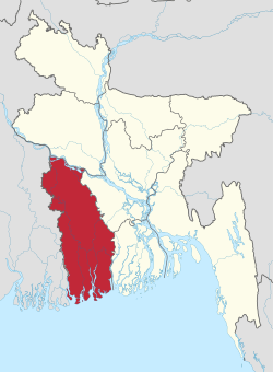
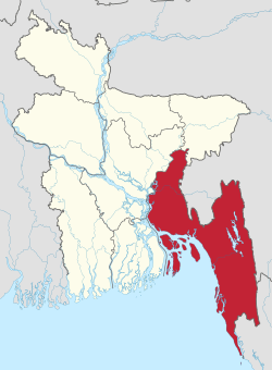 Location of Chittagong in Bangladesh | |
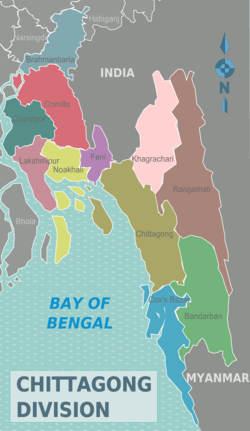 Districts of Chittagong Division | |
| Coordinates: 22°55′N 91°30′E / 22.917°N 91.500°ECoordinates: 22°55′N 91°30′E / 22.917°N 91.500°E | |
| Country |
|
| Capital | Chittagong |
| Area | |
| • Total | 33,771.18 km2 (13,039.13 sq mi) |
| Population (2011 census) | |
| • Total | 28,423,019 |
| • Density | 840/km2 (2,200/sq mi) |
| Time zone | UTC+6 (BST) |
| ISO 3166 code | BD-B |
| Notable sport teams | Chittagong Vikings, Chittagong Division, Chittagong Abahani |
| Website |
www |
Chittagong Division, officially known as Chattogram Division,[1] is geographically the largest of the eight administrative divisions of Bangladesh. It covers the south-easternmost areas of the country, with a total area of 33,771.18 km2 (13,039.13 sq mi)[2] and a population at the 2011 census of 28,423,019. The administrative division includes mainland Chittagong District, neighbouring districts and the Chittagong Hill Tracts.
Chittagong Division is home to Cox's Bazar, one of the world's longest natural beaches; as well as St. Martin's Island, Bangladesh's sole coral reef.
Administration
Chittagong Division is subdivided into eleven districts (zilas) and thence into 99 sub-districts (upazilas). The first six districts listed below comprise the north-western portion (37.6%) of the division, while the remaining five comprise the south-eastern portion (62.4%), the two portions being separated by the lower (or Bangladeshi) stretch of the Feni River; the upland districts of Khagrachhari, Rangamati and Bandarban together comprise that area previously known as the Chittagong Hill Tracts. Before 1995, the four districts of Sylhet Division were also a part of Chittagong Division.
| Name | Capital | Area (km²) | Population 1991 Census | Population 2001 Census | Population 2011 Census |
|---|---|---|---|---|---|
| Brahmanbaria District | Brahmanbaria | 1,881.20 | 2,141,745 | 2,398,254 | 2,840,498 |
| Comilla District | Comilla | 3,146.30 | 4,032,666 | 4,595,539 | 5,387,288 |
| Chandpur District | Chandpur | 1,645.32 | 2,032,449 | 2,271,229 | 2,416,018 |
| Lakshmipur District | Lakshmipur | 1,440.39 | 1,312,337 | 1,489,901 | 1,729,188 |
| Noakhali District | Noakhali | 3,685.87 | 2,217,134 | 2,577,244 | 3,108,083 |
| Feni District | Feni | 990.36 | 1,096,745 | 1,240,384 | 1,437,371 |
| North of the Feni River (proposed new Comilla Division) | 12,789.50 | 12,863,076 | 14,572,569 | 16,918,446 | |
| Khagrachhari District | Khagrachhari | 2,749.16 | 342,488 | 525,664 | 613,917 |
| Rangamati District | Rangamati | 6,116.11 | 401,388 | 508,182 | 595,979 |
| Bandarban District | Bandarban | 4,479.01 | 230,569 | 298,120 | 388,335 |
| Chittagong District | Chittagong | 5,282.92 | 5,296,127 | 6,612,140 | 7,616,352 |
| Cox's Bazar District | Cox's Bazar | 2,491.85 | 1,419,260 | 1,773,709 | 2,289,990 |
| South of the Feni River) (proposed reduced Chittagong Division) | 21,119.05 | 7,689,832 | 9,717,815 | 11,504,546 | |
| Total Division | Chittagong | 33,908.55 | 20,552,908 | 24,290,384 | 28,423,019 |
See also
Sources
Census figures for 1991, 2001 and 2011 are from Bangladesh Bureau of Statistics, Population Census Wing. The 2011 Census figures are based on preliminary results.
References
- ↑ Mahadi Al Hasnat (2 April 2018). "Mixed reactions as govt changes English spellings of 5 district names". Dhaka Tribune. Retrieved 8 April 2018.
- ↑ Sajahan Miah (2012). "Chittagong Division". In Sirajul Islam and Ahmed A. Jamal. Banglapedia: National Encyclopedia of Bangladesh (Second ed.). Asiatic Society of Bangladesh.
External links
| Wikivoyage has a travel guide for Chittagong Division. |
Places adjacent to Chittagong Division | ||||||||||
|---|---|---|---|---|---|---|---|---|---|---|
| ||||||||||

| Barishal Division | 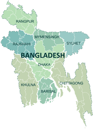 | |
|---|---|---|
| Chattagram Division | ||
| Dhaka Division | ||
| Khulna Division | ||
| Mymensingh Division | ||
| Rajshahi Division | ||
| Rangpur Division | ||
| Sylhet Division | ||