Mymensingh Division
| Mymensingh Division ময়মনসিংহ বিভাগ Nasratshahi | |
|---|---|
| Division of Bangladesh | |
 | |
| Coordinates: 24°10′N 90°25′E / 24.167°N 90.417°ECoordinates: 24°10′N 90°25′E / 24.167°N 90.417°E | |
| Country |
|
| Seat | Mymensingh |
| Area | |
| • Total | 10,584 km2 (4,087 sq mi) |
| Population (2011 census) | |
| • Total | 11,370,000 |
| • Density | 1,100/km2 (2,800/sq mi) |
| Time zone | UTC+6 (BST) |
| ISO 3166 code | BD-C |
| Website |
www |
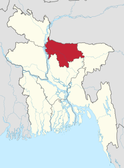
Mymensingh Division (Bengali: ময়মনসিংহ বিভাগ) is one of the eight administrative divisions of Bangladesh. It has an area of 10,485 km² and a population of 11,370,000 as of the 2011 census. It was created in 2015 from districts previously comprising the northern part of Dhaka Division. Its headquarters are in Mymensingh city in Mymensingh District.
History
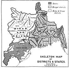
The Greater Mymensingh region (Mymensingh District along with six other neighbouring districts) was created as a Mymensingh district by the British Indian government in 1787. Later it was reorganized in two phases into six districts: Mymensingh, Kishoreganj, Netrakona,Jamalpur, Tangail, and Sherpur.[1]
On 12 January 2015 prime minister Sheikh Hasina declared the establishment of a new Mymensingh Division. The initial intention was to carve six districts (those comprising the original Mymensingh district of 1787) out of the Dhaka Division. However, while four of the districts were eager for the establishment of a new division, people in the Tangail and Kishoreganj Districts wished to remain part of Dhaka Division.[2][3] On 14 September 2015 Mymensingh was officially announced as a division consisting four districts.[4][5][6]
Administrative divisions
| Name | Headquarter | Area (km²) | Population 1991 Census | Population 2001 Census | Population 2011 Census |
|---|---|---|---|---|---|
| Jamalpur District | Jamalpur | 2,115.16 | 1,874,440 | 2,107,209 | 2,292,674 |
| Mymensingh District | Mymensingh | 4,394.57 | 3,957,182 | 4,489,726 | 5,110,272 |
| Netrokona District | Netrokona | 2,794.28 | 1,730,935 | 1,988,188 | 2,229,642 |
| Sherpur District | Sherpur | 1,364.67 | 1,138,629 | 1,279,542 | 1,358,325 |
| Total Division | Mymensingh | 10,584.06 | 8,701,186 | 9,864,665 | 11,370,000 |
Census figures for 1991, 2001 and 2011 are from Bangladesh Bureau of Statistics, Population Census Wing. The 2011 Census figures are based on preliminary results.
References
- ↑ Historical Dictionary of the Bengalis. Scarecrow Press. Retrieved 2015-01-26.
- ↑ "প্রচ্ছদ বাংলাদেশ বিবিধ ময়মনসিংহকে বিভাগ ঘোষণার খবর আনন্দের জোয়ার নির্দেশ পায়নি মন্ত্রিপরিষদ বিভাগ" (14–70). Prothom Alo. 14 January 2015. Retrieved 14 January 2015.
- ↑ "Mymensingh to become new division". Archived from the original on 15 February 2015. Retrieved 26 January 2015.
- ↑ "Govt gives final approval for Mymensingh as country's eighth administrative division". Bdnews24.com. 14 September 2015. Retrieved 15 September 2015.
- ↑ "Mymensingh a division now". Dhaka Tribune. 15 September 2015. Archived from the original on 8 December 2015. Retrieved 15 September 2015.
- ↑ "Mymensingh to become eighth division of Bangladesh". Daily Star. 14 September 2015. Retrieved 15 September 2015.
Places adjacent to Mymensingh Division | |
|---|---|
| Barishal Division | 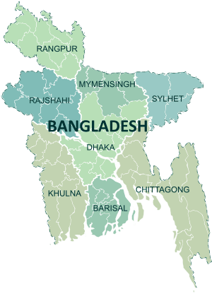 | |
|---|---|---|
| Chattagram Division | ||
| Dhaka Division | ||
| Khulna Division | ||
| Mymensingh Division | ||
| Rajshahi Division | ||
| Rangpur Division | ||
| Sylhet Division | ||