Rangamati
| Rangamati রাঙামাটি 𑄢𑄋𑄟𑄖𑄳𑄡 ရင်္ဂါမတီ Rangamatte (Chakma) | |
|---|---|
 | |
| Nickname(s): Lake City of Bangladesh | |
 Rangamati Location in Bangladesh | |
| Coordinates: 22°38′N 92°12′E / 22.633°N 92.200°E | |
| Country |
|
| Division | Chittagong Division |
| District | Rangamati District |
| Government | |
| • Pouroshava Mayor | Akbor Hossain Chodury |
| • Chakma Raja (Chakma Circle Chief) | Devasish Roy |
| • Chairman Of Chittagong Hill Tracts Regional Council | Jyotirindro Bodhipriyo Larma alais Santu Larma |
| Elevation | 14 m (49 ft) |
| Time zone | UTC+6 (BST) |
| Postal Code | 4500 |
| Area code(s) | 0351 |
| Climate | Am |
Rangamati (Bengali: রাঙামাটি; Chakma: 𑄢𑄋𑄟𑄖𑄳𑄡; Arakanese: ရင်္ဂါမတီ) is the administrative headquarters of Rangamati Hill District in the Chittagong Hill Tracts of Bangladesh. It is also a Capital city of Chittagong Hill Tracts. The town is located at 22°37'60N 92°12'0E and has an altitude of 14 metres (46 ft).[1] The district is administered by an office named as District Administration, Rangamati
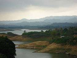
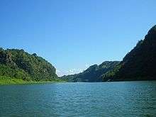
From Chittagong a 77 kilometres (48 mi) road leads to Rangamati. The township is located on the western bank of the Kaptai lake. Rangamati is a holiday destination because of its landscape, scenic beauty, lake, colourful indigenous groups (Chakma, Marma, Tripura, Pangkhua indigenous Assamese people etc.), its flora and fauna, indigenous museum, hanging bridge etc. Sajek Vallery
Climate
| Climate data for Khulna | |||||||||||||
|---|---|---|---|---|---|---|---|---|---|---|---|---|---|
| Month | Jan | Feb | Mar | Apr | May | Jun | Jul | Aug | Sep | Oct | Nov | Dec | Year |
| Average high °C (°F) | 25.7 (78.3) |
28.5 (83.3) |
32.0 (89.6) |
33.0 (91.4) |
32.7 (90.9) |
31.2 (88.2) |
30.5 (86.9) |
31.0 (87.8) |
31.5 (88.7) |
31.4 (88.5) |
29.1 (84.4) |
26.2 (79.2) |
30.2 (86.4) |
| Average low °C (°F) | 14.0 (57.2) |
15.9 (60.6) |
20.0 (68) |
22.9 (73.2) |
24.0 (75.2) |
24.9 (76.8) |
24.8 (76.6) |
24.9 (76.8) |
24.8 (76.6) |
23.9 (75) |
20.6 (69.1) |
16.0 (60.8) |
21.4 (70.5) |
| Average precipitation mm (inches) | 5.1 (0.201) |
24.3 (0.957) |
62.1 (2.445) |
147.9 (5.823) |
319.7 (12.587) |
504.8 (19.874) |
572.6 (22.543) |
435.2 (17.134) |
259.6 (10.22) |
152.2 (5.992) |
55.7 (2.193) |
9.5 (0.374) |
2,548.7 (100.343) |
| Average precipitation days | 1 | 2 | 3 | 8 | 13 | 18 | 21 | 20 | 15 | 8 | 4 | 1 | 114 |
| Average relative humidity (%) | 77 | 69 | 67 | 72 | 78 | 84 | 85 | 85 | 85 | 84 | 82 | 81 | 79 |
| Source: Bangladesh Meteorological Department[2][3][4][5][6] | |||||||||||||
Gallery
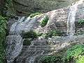 Lower portion of the Shuvolong Fall
 Mummified Body of the Top Mohanto at Rajbana Vihara
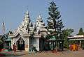 Rajbana Vihara, a renowned Buddhist Temple at Rangamati
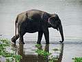 Wild Asian elephant, can be seen in the hilly forests of Rangamati
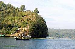 Kaptai Lake Barkal Upazila
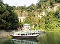 Shuvolong waterfall in dry season
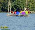 Life in Water
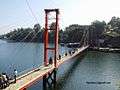 Hanging bridge Rangamati
References
- ↑ Location of Rangamati - Falling Rain Genomics
- ↑ "Monthly Maximum Temperature". Bangladesh Meteorological Department. Retrieved January 31, 2016.
- ↑ "Monthly Minimum Temperature". Bangladesh Meteorological Department. Retrieved January 31, 2016.
- ↑ "Normal Monthly Rainfall". Bangladesh Meteorological Department. Retrieved January 31, 2016.
- ↑ "Normal Monthly Rainy Day". Bangladesh Meteorological Department. Retrieved January 31, 2016.
- ↑ "Normal Monthly Humidity". Bangladesh Meteorological Department. Retrieved January 31, 2016.
| Wikimedia Commons has media related to Rangamati. |
| Upazila/Thana: | ||
|---|---|---|