Orange, New Hampshire
Orange is a town in Grafton County, New Hampshire, United States. The population was 331 at the 2010 census.[1]
Orange, New Hampshire | |
|---|---|
Town | |
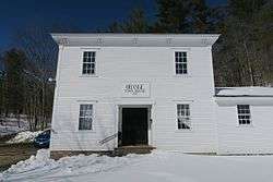 Orange Town House | |
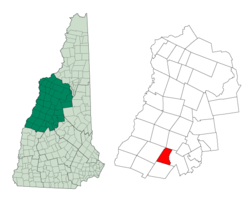 Location in Grafton County, New Hampshire | |
| Coordinates: 43°39′14″N 71°58′17″W | |
| Country | United States |
| State | New Hampshire |
| County | Grafton |
| Incorporated | 1790 |
| Government | |
| • Board of Selectmen | Dorothy Heinrichs, Chair Aaron Allen Tamara Fairbank |
| Area | |
| • Total | 23.2 sq mi (60.2 km2) |
| • Land | 23.2 sq mi (60.1 km2) |
| • Water | 0.04 sq mi (0.1 km2) 0.17% |
| Elevation | 1,216 ft (371 m) |
| Population (2010) | |
| • Total | 331 |
| Time zone | UTC-5 (Eastern) |
| • Summer (DST) | UTC-4 (Eastern) |
| ZIP code | 03741 |
| Area code(s) | 603 |
| FIPS code | 33-58340 |
| GNIS feature ID | 0873692 |
| Website | orangenh |
History
Orange was granted in 1769 and incorporated in 1790. It was originally named "Cardigan", after George Brudenell, fourth Earl of Cardigan. The Cardigan name lives on with Mount Cardigan and Cardigan Mountain State Park. After the American Revolution, voters attempted to rename the town "Bradford", "Middletown", "Liscomb", and finally "Orange". The large quantities of yellow-orange ochre found in Mount Cardigan may have been the source of the name Orange.
Geography
According to the United States Census Bureau, the town has a total area of 23.2 square miles (60 km2), of which 23.2 sq mi (60 km2) is land and 0.04 sq mi (0.10 km2) is water, comprising 0.17% of the town. The highest point in Orange is the summit of Mount Cardigan, at 3,155 feet (962 m) above sea level. U.S. Route 4 passes through the town's southwest corner.
Demographics
| Historical population | |||
|---|---|---|---|
| Census | Pop. | %± | |
| 1790 | 131 | — | |
| 1800 | 203 | 55.0% | |
| 1810 | 229 | 12.8% | |
| 1820 | 293 | 27.9% | |
| 1830 | 405 | 38.2% | |
| 1840 | 463 | 14.3% | |
| 1850 | 451 | −2.6% | |
| 1860 | 382 | −15.3% | |
| 1870 | 340 | −11.0% | |
| 1880 | 335 | −1.5% | |
| 1890 | 245 | −26.9% | |
| 1900 | 213 | −13.1% | |
| 1910 | 176 | −17.4% | |
| 1920 | 166 | −5.7% | |
| 1930 | 99 | −40.4% | |
| 1940 | 109 | 10.1% | |
| 1950 | 82 | −24.8% | |
| 1960 | 83 | 1.2% | |
| 1970 | 103 | 24.1% | |
| 1980 | 197 | 91.3% | |
| 1990 | 237 | 20.3% | |
| 2000 | 299 | 26.2% | |
| 2010 | 331 | 10.7% | |
| Est. 2017 | 306 | [2] | −7.6% |
| U.S. Decennial Census[3] | |||
At the 2000 census there were 299 people, 111 households, and 85 families living in the town. The population density was 12.9 people per square mile (5.0/km²). There were 134 housing units at an average density of 5.8 per square mile (2.2/km²). The racial makeup of the town was 99.67% White and 0.33% Asian. Hispanic or Latino of any race were 0.33%.[4]
Of the 111 households 33.3% had children under the age of 18 living with them, 59.5% were married couples living together, 8.1% had a female householder with no husband present, and 23.4% were non-families. 15.3% of households were one person and 4.5% were one person aged 65 or older. The average household size was 2.69 and the average family size was 2.98.
The age distribution was 25.1% under the age of 18, 5.0% from 18 to 24, 35.5% from 25 to 44, 25.1% from 45 to 64, and 9.4% 65 or older. The median age was 38 years. For every 100 females, there were 110.6 males. For every 100 females age 18 and over, there were 103.6 males.
The median household income was $41,250 and the median family income was $40,625. Males had a median income of $34,750 versus $25,938 for females. The per capita income for the town was $17,456. About 6.3% of families and 6.6% of the population were below the poverty line, including 6.0% of those under the age of eighteen and 3.2% of those sixty five or over.
As of May 31, 2016, there were 225 registered voters on the checklist, including 55 Republican, 53 Democrat and 117 undeclared.
References
- United States Census Bureau, American FactFinder, 2010 Census figures. Retrieved March 23, 2011.
- "Annual Estimates of the Resident Population: April 1, 2010 to July 1, 2017 (PEPANNRES): Minor Civil Divisions – New Hampshire". Archived from the original on February 13, 2020. Retrieved November 14, 2018.
- "Census of Population and Housing". Census.gov. Retrieved June 4, 2016.
- "U.S. Census website". United States Census Bureau. Retrieved 2008-01-31.
External links
Places adjacent to Orange, New Hampshire | |
|---|---|
Municipalities and communities of Grafton County, New Hampshire, United States | ||
|---|---|---|
| City |  Map of New Hampshire highlighting Grafton County | |
| Towns |
| |
| Township | ||
| CDPs | ||
| Other villages | ||