Lyman, New Hampshire
Lyman is a town in Grafton County, New Hampshire, United States. The population was 533 at the 2010 census.[1]
Lyman, New Hampshire | |
|---|---|
Town | |
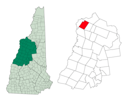 Location in Grafton County, New Hampshire | |
| Coordinates: 44°15′16″N 71°57′00″W | |
| Country | United States |
| State | New Hampshire |
| County | Grafton |
| Incorporated | 1761 |
| Villages | Tinkerville Parker Hill |
| Government | |
| • Board of Selectmen | Bruce Beane, Chair James Trudell Wendy Ho-Sing-Loy |
| Area | |
| • Total | 28.8 sq mi (74.5 km2) |
| • Land | 28.5 sq mi (73.7 km2) |
| • Water | 0.3 sq mi (0.8 km2) 1.01% |
| Elevation | 1,220 ft (372 m) |
| Population (2010) | |
| • Total | 533 |
| • Density | 19/sq mi (7.2/km2) |
| Time zone | UTC-5 (Eastern) |
| • Summer (DST) | UTC-4 (Eastern) |
| ZIP code | 03585 |
| Area code(s) | 603 |
| FIPS code | 33-44100 |
| GNIS feature ID | 0873653 |
| Website | www |
History
Lyman, along with Grantham, Lisbon, and eleven Vermont towns, was granted as compensation to General Phineas Lyman, a commander in the French and Indian War. According to the county gazetteer, "It was granted to Daniel Lyman and sixty-three others, November 10, 1761, its name being derived from the fact that eleven of the grantees bore the name of Lyman. The grantees failed to comply with the requirements of their charter, and thus forfeited their grant, but an extension of time was granted them July 20, 1769."[2] Lyman was incorporated in 1761. In 1880 it had a population of 665.
Geography
According to the United States Census Bureau, the town has a total area of 28.8 square miles (75 km2), of which 28.5 sq mi (74 km2) is land and 0.3 sq mi (0.78 km2) is water, comprising 1.01% of the town. The highest point in town is 2,285 feet (696 m) above sea level, just east of the summit of Signal Mountain, a knob along the ridge of Gardner Mountain, which defines the town's western boundary.
The town's initial grant included land along the Connecticut River. In 1854 the portion of Lyman found west of "Gardner's Mountain" was separately incorporated as Monroe.[2]
Demographics
| Historical population | |||
|---|---|---|---|
| Census | Pop. | %± | |
| 1790 | 202 | — | |
| 1800 | 534 | 164.4% | |
| 1810 | 948 | 77.5% | |
| 1820 | 1,270 | 34.0% | |
| 1830 | 1,321 | 4.0% | |
| 1840 | 1,496 | 13.2% | |
| 1850 | 1,442 | −3.6% | |
| 1860 | 743 | −48.5% | |
| 1870 | 658 | −11.4% | |
| 1880 | 654 | −0.6% | |
| 1890 | 543 | −17.0% | |
| 1900 | 426 | −21.5% | |
| 1910 | 374 | −12.2% | |
| 1920 | 310 | −17.1% | |
| 1930 | 299 | −3.5% | |
| 1940 | 363 | 21.4% | |
| 1950 | 241 | −33.6% | |
| 1960 | 201 | −16.6% | |
| 1970 | 213 | 6.0% | |
| 1980 | 281 | 31.9% | |
| 1990 | 388 | 38.1% | |
| 2000 | 487 | 25.5% | |
| 2010 | 533 | 9.4% | |
| Est. 2017 | 526 | [3] | −1.3% |
| U.S. Decennial Census[4] | |||
At the 2000 census there were 487 people, 211 households, and 150 families living in the town. The population density was 17.1 people per square mile (6.6/km²). There were 280 housing units at an average density of 9.8 per square mile (3.8/km²). The racial makeup of the town was 98.36% White, 0.21% African American, 0.21% Native American, 0.21% Asian, 0.41% from other races, and 0.62% from two or more races. Hispanic or Latino of any race were 0.21%.[5]
Of the 211 households 24.6% had children under the age of 18 living with them, 61.1% were married couples living together, 4.7% had a female householder with no husband present, and 28.9% were non-families. 20.9% of households were one person and 4.3% were one person aged 65 or older. The average household size was 2.31 and the average family size was 2.64.
The age distribution was 19.9% under the age of 18, 4.5% from 18 to 24, 32.0% from 25 to 44, 31.6% from 45 to 64, and 11.9% 65 or older. The median age was 42 years. For every 100 females, there were 102.1 males. For every 100 females age 18 and over, there were 105.3 males.
The median household income was $46,607 and the median family income was $48,365. Males had a median income of $27,500 versus $23,375 for females. The per capita income for the town was $22,332. About 3.5% of families and 6.5% of the population were below the poverty line, including 6.5% of those under age 18 and 6.7% of those age 65 or over.
References
- United States Census Bureau, American FactFinder, 2010 Census figures. Retrieved March 23, 2011.
- Hamilton Child, Gazetteer of Grafton County NH, 1709-1886, The Syracuse Journal Company, Syracuse NY, June 1886, p. 512
- "Annual Estimates of the Resident Population: April 1, 2010 to July 1, 2017 (PEPANNRES): Minor Civil Divisions – New Hampshire". Archived from the original on February 13, 2020. Retrieved November 14, 2018.
- "Census of Population and Housing". Census.gov. Retrieved June 4, 2016.
- "U.S. Census website". United States Census Bureau. Retrieved 2008-01-31.
External links
- Town of Lyman official website
- New Hampshire Economic and Labor Market Information Bureau Profile
- Lisbon Area Historical Society
Places adjacent to Lyman, New Hampshire | |
|---|---|
Municipalities and communities of Grafton County, New Hampshire, United States | ||
|---|---|---|
| City | 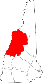 Map of New Hampshire highlighting Grafton County | |
| Towns |
| |
| Township | ||
| CDPs | ||
| Other villages | ||