Rumney, New Hampshire
Rumney is a town in Grafton County, New Hampshire, United States. The population was 1,480 at the 2010 census.[1] The town is located at the southern edge of the White Mountain National Forest.
Rumney, New Hampshire | |
|---|---|
Town | |
 Seal | |
 Location in Grafton County, New Hampshire | |
| Coordinates: 43°48′15″N 71°48′48″W | |
| Country | United States |
| State | New Hampshire |
| County | Grafton |
| Incorporated | 1767 |
| Villages | Rumney Rumney Depot Quincy Stinson Lake West Rumney |
| Government | |
| • Board of selectmen | Robert Berti, Chair George Bonfiglio Ed Haskell |
| • Town Administrator | Joe Chivell |
| Area | |
| • Total | 42.6 sq mi (110.3 km2) |
| • Land | 41.7 sq mi (107.9 km2) |
| • Water | 0.9 sq mi (2.4 km2) 2.15% |
| Elevation | 509 ft (155 m) |
| Population (2010) | |
| • Total | 1,480 |
| • Density | 35/sq mi (13/km2) |
| Time zone | UTC-5 (Eastern) |
| • Summer (DST) | UTC-4 (Eastern) |
| ZIP code | 03266 |
| Area code(s) | 603 |
| FIPS code | 33-65940 |
| GNIS feature ID | 0873711 |
| Website | www |
History
Rumney was named after Robert Marsham, 2nd Baron Romney (pronounced Rumney). The town was originally granted in 1761 by Governor Benning Wentworth to settlers from Colchester and East Haddam, Connecticut. It was first settled in 1765; however, some grantees failed to comply with the charter, so Rumney was regranted to another group of settlers in 1767.
Farmers found the town's soil fertile. By 1859, when the population was 1,109, other industries included fifteen sawmills, a large tannery, and a ladder factory. The Boston, Concord and Montreal Railroad commenced service to West Rumney in 1850-1851.[2]
Geography
According to the United States Census Bureau, the town has a total area of 42.6 square miles (110.3 km2), of which 41.7 square miles (108.0 km2) is land and 0.9 square miles (2.3 km2) is water, comprising 2.15% of the town.[3] The highest point in Rumney is 2,960 feet (902 m) above sea level on the southern slope of Carr Mountain. The Baker River flows from west to east through the center of the town, roughly paralleled by New Hampshire Route 25.
The town of Rumney contains several smaller villages. Rumney village, the town's central settlement, lies just north of the Baker River. Directly to the south, across the Baker River and adjacent to Route 25, is the village of Rumney Depot. The village of Stinson Lake, comprising development around the lake and at the foot of adjacent Stinson Mountain, is in the northern corner of the town, and West Rumney is located along Route 25 near the town's western border.
Rumney is home to the "Polar Caves", which are well known for their geological views and glowing rock formations. It is located along Route 25 near the town's eastern border.
Rumney Rocks
Rumney Rocks, located between Rumney village and West Rumney, is a rock climbing destination renowned for its sport climbing routes.[4]
The majority of the climbing is found on the numerous small cliff faces on the south face of Rattlesnake Mountain, much of which lies within the White Mountain National Forest. These cliffs are mostly made of schist, with some being granite, and vary from long smooth slabs to wildly overhung roofs and aretes. They range in height, with most falling between 40 feet (12 m) and 90 feet (27 m), but a few reach over 300 feet (91 m).
Most climbs are well bolted, with a few requiring additional protection. The climbs range from 5.0 to 5.15a, with the majority of routes falling between 5.10 and 5.12.[5]
Demographics
| Historical population | |||
|---|---|---|---|
| Census | Pop. | %± | |
| 1790 | 411 | — | |
| 1800 | 624 | 51.8% | |
| 1810 | 765 | 22.6% | |
| 1820 | 864 | 12.9% | |
| 1830 | 993 | 14.9% | |
| 1840 | 1,110 | 11.8% | |
| 1850 | 1,109 | −0.1% | |
| 1860 | 1,103 | −0.5% | |
| 1870 | 1,165 | 5.6% | |
| 1880 | 1,056 | −9.4% | |
| 1890 | 947 | −10.3% | |
| 1900 | 837 | −11.6% | |
| 1910 | 850 | 1.6% | |
| 1920 | 911 | 7.2% | |
| 1930 | 858 | −5.8% | |
| 1940 | 861 | 0.3% | |
| 1950 | 859 | −0.2% | |
| 1960 | 820 | −4.5% | |
| 1970 | 870 | 6.1% | |
| 1980 | 1,212 | 39.3% | |
| 1990 | 1,446 | 19.3% | |
| 2000 | 1,480 | 2.4% | |
| 2010 | 1,480 | 0.0% | |
| Est. 2017 | 1,544 | [6] | 4.3% |
| U.S. Decennial Census[7] | |||
As of the census[8] of 2000, there were 1,480 people, 569 households, and 393 families residing in the town. The population density was 35.3 people per square mile (13.6/km²). There were 879 housing units at an average density of 21.0 per square mile (8.1/km²). The racial makeup of the town was 98.04% White, 0.41% African American, 0.54% Native American, 0.41% Asian, 0.07% Pacific Islander, 0.20% from other races, and 0.34% from two or more races. Hispanic or Latino of any race were 0.61% of the population.
There were 569 households out of which 29.9% had children under the age of 18 living with them, 57.5% were married couples living together, 6.3% had a female householder with no husband present, and 30.8% were non-families. 23.2% of all households were made up of individuals and 8.8% had someone living alone who was 65 years of age or older. The average household size was 2.55 and the average family size was 3.00.
In the town, the population was spread out with 25.4% under the age of 18, 5.5% from 18 to 24, 25.9% from 25 to 44, 27.0% from 45 to 64, and 16.1% who were 65 years of age or older. The median age was 41 years. For every 100 females, there were 102.7 males. For every 100 females age 18 and over, there were 102.2 males.
The median income for a household in the town was $38,125, and the median income for a family was $42,895. Males had a median income of $26,594 versus $21,705 for females. The per capita income for the town was $17,169. About 4.9% of families and 9.5% of the population were below the poverty line, including 15.0% of those under age 18 and 6.7% of those age 65 or over.
Stereographic cards c. 1880
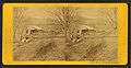 Sawmill
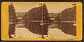
 Rattlesnake Mountain
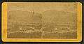 General view from train
Notable people
- Robert Burns, US congressman
- Nathan Clifford, diplomat, 19th US Attorney General, and Associate Justice of the Supreme Court
- Mary Baker Eddy, founder of Christian Science (1879)
- Jonathan Myles, Olympic luger
See also
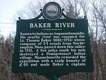
- New Hampshire Historical Marker No. 55: Baker River
- New Hampshire Historical Marker No. 174: Loveland Bridge
References
- United States Census Bureau, American FactFinder, 2010 Census figures. Retrieved March 23, 2011.
- Coolidge, Austin J.; John B. Mansfield (1859). A History and Description of New England. Boston, Massachusetts: A.J. Coolidge. p. 638.
coolidge mansfield history description new england 1859.
- "Geographic Identifiers: 2010 Demographic Profile Data (G001) - Rumney town, New Hampshire". United States Census Bureau. Retrieved November 13, 2011.
- "Basic Rock Climbing Rumney Rocks". REI. Retrieved 2008-05-08.
- "Rumney". rockclimbing.com. Retrieved July 6, 2009.
- "Annual Estimates of the Resident Population: April 1, 2010 to July 1, 2017 (PEPANNRES): Minor Civil Divisions – New Hampshire". Archived from the original on February 13, 2020. Retrieved November 14, 2018.
- "Census of Population and Housing". Census.gov. Retrieved June 4, 2016.
- "U.S. Census website". United States Census Bureau. Retrieved 2008-01-31.
External links
- Town of Rumney official website
- Byron G. Merrill Library
- Rumney Historical Society
- Mary Baker Eddy House
- Polar Caves Park
- Snowdrifters Snowmobile Club
- Rumney Climbers Association
- Rockclimbing in Rumney -- Dartmouth Outing Club
- Rumney Bible Conference
- New Hampshire Economic and Labor Market Information Bureau Profile
Places adjacent to Rumney, New Hampshire | |
|---|---|
Municipalities and communities of Grafton County, New Hampshire, United States | ||
|---|---|---|
| City | 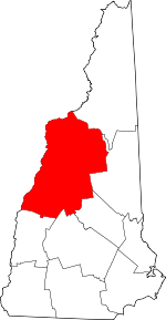 Map of New Hampshire highlighting Grafton County | |
| Towns |
| |
| Township | ||
| CDPs | ||
| Other villages | ||